Kalangadoo, South Australia
| Kalangadoo South Australia | |||||||||||||
|---|---|---|---|---|---|---|---|---|---|---|---|---|---|
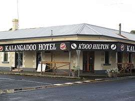 Kalangadoo Hotel | |||||||||||||
 Kalangadoo | |||||||||||||
| Coordinates | 37°33′S 140°42′E / 37.550°S 140.700°ECoordinates: 37°33′S 140°42′E / 37.550°S 140.700°E | ||||||||||||
| Population | 305 (2006 census)[1] | ||||||||||||
| Established | 1891 | ||||||||||||
| Postcode(s) | 5278 | ||||||||||||
| Time zone | ACST (UTC+9:30) | ||||||||||||
| • Summer (DST) | ACDT (UTC+10:30) | ||||||||||||
| Location | 50 km (31 mi) N of Mount Gambier | ||||||||||||
| LGA(s) | Wattle Range Council | ||||||||||||
| State electorate(s) | Mount Gambier | ||||||||||||
| Federal Division(s) | Barker | ||||||||||||
| |||||||||||||
Kalangadoo is a small district in South Australia, Australia.[2] It is about 50 km north of Mount Gambier, in the heart of red gum country. The area was originally proclaimed as Kalangadoo East in 1891, and the name changed to Kalangadoo in 1940. The aboriginal word means "Big trees in water."[3][4] Today the small business district includes a general store, a farm supply store, a pub, and a timber mill. The disused railway station houses a small museum. At the 2006 census, Kalangadoo had a population of 305.[1]
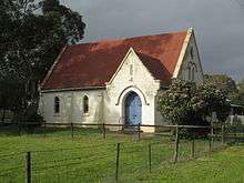
Kalangadoo is the centre of a rich agricultural district that specialises in potatoes and timber, as well as apple orchards, beef cattle, sheep and dairy cattle. The village flourished after the narrow gauge railroad arrived in 1887. It languished after World War II as farmers used their cars to shop in Penola and Mount Gambier.[5] The Anglican Church of St Alban the Martyr is active, as are the Catholic church (built 1904) and the Presbyterian church (opened 1914).[6] The Uniting Church opened in 1906 and closed in 2007, with its old buildings used for the weekly farmers' market.[7] The public school established in 1892 reached a peak enrolment of 150 pupils in 1966, falling to 74 by 1991.[8][9]
The historic Kalangadoo House, off the Kalangadoo-Nangwarry Road, is located on the South Australian Heritage Register.[10]
References
| Wikimedia Commons has media related to Kalangadoo, South Australia. |
- 1 2 Australian Bureau of Statistics (25 October 2007). "Kalangadoo (L) (Urban Centre/Locality)". 2006 Census QuickStats. Retrieved 2 August 2011.
- ↑ "Kalangadoo". Gazetteer of Australia online. Geoscience Australia, Australian Government.
- ↑ Reg Chuck, Big trees in water: Kalangadoo, the town and the people, 1850-1990 (1991) p 20
- ↑ "Kalangadoo". Place names Online. Government of South Australia. Retrieved 2006-05-21.
- ↑ Chuck, 1991
- ↑ Chuck, 1991, pp 186-87
- ↑ Raymond E. Pocock, Kalangadoo, the Church of Saint Alban the Martyr: a brief history (1968)
- ↑ Chuck, p 135
- ↑ Nick Hunt, Kalangadoo Primary School (1992)
- ↑ "Dwelling ('Kalangadoo House')". South Australian Heritage Register. Department of Environment, Water and Natural Resources. Retrieved 26 August 2016.
Further reading
- Chuck, Reg. Big trees in water: Kalangadoo, the town and the people, 1850-1990 (1991) 237pp detailed history ISBN 0646081535