Piccaninnie Ponds Conservation Park
| Piccaninnie Ponds Conservation Park South Australia | |
|---|---|
|
IUCN category III (natural monument or feature) | |
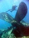
 Cave diving at Piccaninnie Ponds | |
 Piccaninnie Ponds Conservation Park | |
| Nearest town or city | Donovans |
| Coordinates | 38°03′03″S 140°56′11″E / 38.05083°S 140.93639°ECoordinates: 38°03′03″S 140°56′11″E / 38.05083°S 140.93639°E |
| Established | 16 October 1969[1] |
| Area | 8.64 km2 (3.3 sq mi)[1] |
| Managing authorities | Department of Environment, Water and Natural Resources |
| Website | Piccaninnie Ponds Conservation Park |
| See also | Protected areas of South Australia |
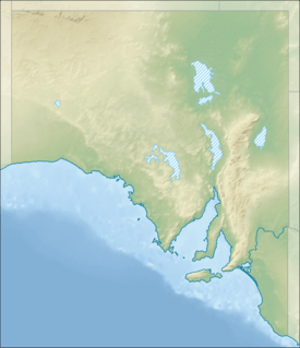
Piccaninnie Ponds Conservation Park is a protected area of 862 hectares (2,130 acres) located in southeastern South Australia near Mount Gambier.
Description
The Piccaninnie Ponds Conservation Park is located in the south-east of South Australia in the gazetted locality of Wye on the continental coastline overlooking Discovery Bay about 490 kilometres (300 mi) southeast of the state capital of Adelaide and 30 kilometres (19 mi) south-east of the city of Mount Gambier.[2][3]
The conservation park conserves a wetland fed by freshwater springs in a karst landscape.[4]
It is close to the border with Victoria and is part of the Discovery Bay to Piccaninnie Ponds Important Bird Area, identified by BirdLife International as being of global significance for several bird species.[5] It is a listed Ramsar site.[6] The park contains a walking track through coastal woodland to a viewing platform overlooking the wetlands.[7]
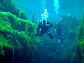
Recreational diving
Piccaninnie Ponds is a popular site for both snorkelling and cave diving. It contains three main features of interest to cave divers. The ‘First Pond’ is an open depression about 10 metres (33 ft) deep with a silt floor and much aquatic life, the ‘Chasm’ is a sinkhole with a depth of over 100 metres (330 ft), and the ‘Cathedral’ is an enclosed area with limestone formations and a depth of about 35 metres (115 ft).[4] Underwater visibility is excellent and may exceed 40 metres (130 ft). Snorkelling and cave diving at Piccaninnie Ponds is by permit only.
See also
- Ewens Ponds
- List of Ramsar sites in Australia
- List of sinkholes of Australia
- Protected areas of South Australia
References
- 1 2 "Protected Areas Information System - reserve list (as of 11 July 2016)" (PDF). Department of Environment Water and Natural Resources. 11 July 2016. Retrieved 14 July 2016.
- ↑ South Australia. National Parks and Wildlife Service. South East District; Sutherland, Andrea; South Australia. National Parks and Wildlife Service (1992), Piccaninnie Ponds Conservation Park management plan, South East, South Australia (PDF), Dept. of Environment and Planning, pp. 2–3, ISBN 978-0-7308-2663-7
- ↑ "Search result for "Piccaninnie Ponds Conservation Park" (Record no SA0054911) with the following layers selected - "Suburbs and Localities" and "Place names (gazetteer)"". Property Location Browser. Government of South Australia. Retrieved 1 September 2016.
- 1 2 "Piccaninnie Ponds - 5L072". Richard "Harry" Harris. Archived from the original on February 11, 2012. Retrieved 9 October 2013.
- ↑ "IBA: Discovery Bay to Piccaninnie Ponds". Birdata. Birds Australia. Retrieved 2011-06-18.
- ↑ Peddie, Clare. "Piccaninnie Ponds now a wetland world wonder". The Advertiser. Retrieved 24 January 2013.
- ↑ Limestone Coast brochure
Further reading
- Horne, P.; (1985), CDAA Research Group Report No. 3: Piccaninnie Ponds Mapping Project, November 1984 – April 1985 (ISBN 0 7316 7208 9) OCLC: 27574762.
- Horne, P; and Harris, R.; (2009), Piccaninnie Ponds Collaborative Research Project: Exploration and General Research Activities, May/June 2008 and Oct/Nov 2009 (with South Australian Department of Water, Land and Biodiversity Conservation (DWLBC) and the South Australian Department for Environment and Heritage (DEH)).
External links
- Piccaninnie Ponds Conservation Park official webpage
- Ponds Conservation Park Diving and Snorkelling Guidelines (PDF download)
- Piccaninnie Ponds Conservation Park webpage on protected planet