Kırkağaç
| Kırkağaç | |
|---|---|
| District | |
 | |
 Location of Kırkağaç within Turkey. | |
 Kırkağaç Location of Kırkağaç | |
| Coordinates: 39°06′N 27°40′E / 39.100°N 27.667°E | |
| Country |
|
| Region | Aegean |
| Province | Manisa |
| Area[1] | |
| • District | 549.40 km2 (212.12 sq mi) |
| Elevation | 188 m (617 ft) |
| Population (2012)[2] | |
| • Urban | 25,686 |
| • District | 44,991 |
| • District density | 82/km2 (210/sq mi) |
| Time zone | EET (UTC+2) |
| • Summer (DST) | EEST (UTC+3) |
| Postal code | 45xxx |
| Area code(s) | 236 |
| Licence plate | 45 |
| Website | www.kirkagac.bel.tr |
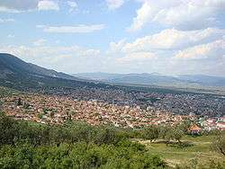
Kırkağaç is a town and district of Manisa Province in the Aegean region of Turkey. According to the 2000 census, population of the district is 48,303 of which 25,093 live in the town of Kırkağaç.[3][4] The district covers an area of 549 km2 (212 sq mi),[5] and the town lies at an elevation of 188 m (617 ft).
Features
Kırkağaç is an agricultural district and known for its variety of melon known as Kırkağaç melon (Turkish: Kırkağaç kavunu).
Notes
- ↑ "Area of regions (including lakes), km²". Regional Statistics Database. Turkish Statistical Institute. 2002. Retrieved 2013-03-05.
- ↑ "Population of province/district centers and towns/villages by districts - 2012". Address Based Population Registration System (ABPRS) Database. Turkish Statistical Institute. Retrieved 2013-02-27.
- ↑ Turkish Statistical Institute. "Census 2000, Key statistics for urban areas of Turkey" (XLS) (in Turkish). Retrieved 2009-04-04.
- ↑ GeoHive. "Statistical information on Turkey's administrative units". Retrieved 2009-04-04.
- ↑ Statoids. "Statistical information on districts of Turkey". Retrieved 2009-04-04.
References
- Falling Rain Genomics, Inc. "Geographical information on Kırkağaç, Turkey". Retrieved 2009-04-04.
External links
- District governor's official website (Turkish)
- Road map of Kırkağaç and environs
- Webshots - Image of Kırkağaç Melon Show
- Buy Kirkagac Melon in the UK
Coordinates: 39°06′14″N 27°40′12″E / 39.10389°N 27.67000°E
This article is issued from Wikipedia - version of the 4/22/2015. The text is available under the Creative Commons Attribution/Share Alike but additional terms may apply for the media files.