Geographical regions of Turkey
"Regions of Turkey" redirects here. For the statistical regions of Turkey, see NUTS of Turkey.
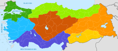
Color-coded geographical regions map of Turkey, with national and provincial borders superimposed in thicker gray and thinner white, respectively. The seven official geographical regions are the Marmara Region (dark green), the Black Sea Region (light green), the Aegean Region (blue), the Mediterranean Region (purple), the Central Anatolia Region (brown), the Eastern Anatolia Region (orange), and the Southeastern Anatolia Region (yellow)
The geographical regions of Turkey comprise seven regions (Turkish: bölge) which were originally defined at the country's First Geography Congress in 1941.[1] These seven regions are subdivided into twenty one sections (Turkish: bölüm), which are further split into numerous areas (Turkish: yöre) as defined by microclimate and bounded by local geographic formations.
"Regions" as defined in this context are merely for geographic, demographic, and economic purposes, and do not refer to an administrative division.
Regions and subregions
- Aegean Region
- Aegean Section
- Edremit Area
- Bakırçay Area
- Gediz Area
- İzmir Area
- Küçük Menderes Area
- Büyük Menderes Area
- Menteşe Area
- Inner Western Anatolia Section
- Aegean Section
- Black Sea Region
- Western Black Sea Section
- Inner Black Sea Area
- Küre Mountains Area
- Central Black Sea Section
- Canik Mountains Area
- Inner Central Black Sea Area
- Eastern Black Sea Section
- Eastern Black Sea Coast Area
- Upper Kelkit - Çoruh Gully
- Western Black Sea Section
- Central Anatolia Region
- Konya Section
- Obruk Plateau
- Konya - Ereğli Vicinity
- Upper Sakarya Section
- Ankara Area
- Porsuk Gully
- Sündiken Mountain Chain Area
- Upper Sakarya Area
- Konya - Ereğli Vicinity
- Middle Kızılırmak Section
- Upper Kızılırmak Section
- Konya Section
- Eastern Anatolia Region
- Upper Euphrates Section
- Erzurum - Kars Section
- Upper Murat - Van Section
- Upper Murat Area
- Van Area
- Hakkari Section
- Marmara Region
- Çatalca - Kocaeli Section
- Adapazarı Area
- Istanbul Area
- Ergene Section
- Southern Marmara Section
- Biga - Gallipoli Area
- Bursa Area
- Karesi Area
- Samanlı Area
- Yıldız Section
- Çatalca - Kocaeli Section
- Mediterranean Region
- Adana Section
- Çukurova - Taurus Mountains Area
- Antakya - Kahramanmaraş Area
- Antalya Section
- Antalya Area
- Göller Area
- Taşeli - Mut Area
- Teke Area
- Adana Section
- Southeastern Anatolia Region
- Middle Euphrates Section
- Gaziantep Area
- Şanlıurfa Area
- Tigris Section
- Diyarbakır Area
- Mardin - Midyat Area
- Middle Euphrates Section
Distinctions of the various regions
The Aegean Region has:
- the longest coastline
The Black Sea Region has:
- highest annual precipitation
- largest forest area
- fewest sunshine hours
- most landslides
The Central Anatolia Region has:
- lowest annual precipitation,
- most erosion
The Eastern Anatolia Region has:
- largest area
- highest altitude
- lowest annual temperature
- coldest winters
- highest temperature difference between seasons
- most volcanic activity
- smallest population
- highest mineral resources
The Marmara Region has:
- smallest area
- lowest altitude
- most climate diversity
- highest energy consumption,
- coolest summers,
- largest population
The Mediterranean Region has:
- highest annual temperature
- mildest winters
- wettest winters,
- most greenhouse farming
The Southeastern Anatolia Region has:
- hottest summers
- driest summers
- smallest forest area
- most sunshine hours
Sources
- ↑ Ali Yiğit, "Geçmişten Günümüze Türkiye'yi Bölgelere Ayıran Çalışmalar ve Yapılması Gerekenler", Ankara Üniversitesi Türkiye Coğrafyası Araştırma ve Uygulama Merkezi, IV. Ulural Coğrafya Sempozyumu, "Avrupa Birliği Sürecindeki Türkiye'de Bölgesel Farklılıklar", pp. 34–35.
This article is issued from Wikipedia - version of the 9/9/2016. The text is available under the Creative Commons Attribution/Share Alike but additional terms may apply for the media files.