Kölbingen
| Kölbingen | ||
|---|---|---|
|
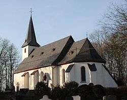
Old parish church on the Schönberg | ||
| ||
 Kölbingen | ||
Location of Kölbingen within Westerwaldkreis district  | ||
| Coordinates: 50°33′13″N 7°56′09″E / 50.55361°N 7.93583°ECoordinates: 50°33′13″N 7°56′09″E / 50.55361°N 7.93583°E | ||
| Country | Germany | |
| State | Rhineland-Palatinate | |
| District | Westerwaldkreis | |
| Municipal assoc. | Westerburg | |
| Government | ||
| • Mayor | Frank Schäfer | |
| Area | ||
| • Total | 4.07 km2 (1.57 sq mi) | |
| Population (2015-12-31)[1] | ||
| • Total | 1,033 | |
| • Density | 250/km2 (660/sq mi) | |
| Time zone | CET/CEST (UTC+1/+2) | |
| Postal codes | 56459 | |
| Dialling codes | 02663 | |
| Vehicle registration | WW | |
| Website | www.koelbingen.de | |

Kölbingen is an Ortsgemeinde – a community belonging to a Verbandsgemeinde – in the Westerwaldkreis in Rhineland-Palatinate, Germany.
Geography
Location
Kölbingen lies roughly 4 km west of Westerburg, in a hollow between the Geisenwald and the Ruhscheid. Since 1972 it has belonged to what was then the newly founded Verbandsgemeinde of Westerburg, a kind of collective municipality.
Constituent communities
Kölbingen’s Ortsteile (divisions) are Schönberg, Möllingen and Kölbingen.
History
In 1494, Kölbingen had its first documentary mention.
Politics
Community council
The council is made up of 17 council members, including the extraofficial mayor (Bürgermeister), who were elected in a majority vote in a municipal election on 13 June 2004.
Economy and infrastructure
Transport
West of the community runs Bundesstraße 255, leading from Montabaur to Herborn. The nearest Autobahn interchange is Diez on the A 3 (Cologne–Frankfurt). The nearest InterCityExpress stop is the railway station at Montabaur on the Cologne-Frankfurt high-speed rail line.
References
- ↑ "Gemeinden in Deutschland mit Bevölkerung am 31. Dezember 2015" (PDF). Statistisches Bundesamt (in German). 2016.
External links
- Kölbingen (German)
- Kölbingen in the collective municipality’s Web pages (German)