Ježica
| Ježica | |
|---|---|
 | |
 Ježica Location in Slovenia | |
| Coordinates: 46°5′41.81″N 14°31′11.97″E / 46.0949472°N 14.5199917°ECoordinates: 46°5′41.81″N 14°31′11.97″E / 46.0949472°N 14.5199917°E | |
| Country |
|
| Traditional region | Upper Carniola |
| Statistical region | Central Slovenia |
| Municipality | Ljubljana |
| Elevation[1] | 303 m (994 ft) |
Ježica (pronounced [ˈjeːʒitsa]; German: Jeschza[2][3]) is a formerly independent settlement in the northern part of the capital Ljubljana in central Slovenia.[1] It was part of the traditional region of Upper Carniola and is now included with the rest of the municipality in the Central Slovenia Statistical Region.[4]
Geography
Ježica is a clustered settlement in an open, sunny area along the Sava River, originally consisting of a core of farms on the high terrace above the Sava. The soil is sandy and there are fields to the west.[1]
Name
Ježica was attested in written sources in 1356 as Gezziczsch (and as Yessicz in 1425 and Jesicz in 1464). The name is a diminutive derived from the Slovene common noun ježa ("small grassy slope between two flat areas in a valley"), referring to the local geography (cf. Ježa).[5] In the past the German name was Jeschza.[3]
History
Roman era
The Roman road from Emona to Celeia passed through Ježica, crossing the Sava River, and a Roman settlement is believed to have stood at the site.[6]:349 In 1880 a Roman grave was discovered near the church.[1] When the Roman Empire collapsed, migrating tribes destroyed the bridge. It was replaced with a ferry that operated until 1724.[7]
Early modern era
In 1515, 6,000 peasants gathered where the spa now stands and negotiated with the imperial commissioners, led by Styrian governor Sigmund Dietrichstein. The officials tried to placate the peasants, but they were unsuccessful, leading to the 1515 Slovene Peasant Revolt.[7]
In 1713, plans were made for the new road from Vienna to Trieste. The work was finished in 1730, and the new bridge was built in Ježica: the first since the destruction of the Roman bridge.[7] Ježica was an important site because it controlled access to the bridge across the Sava; a large building known as Grad (literally, 'castle') was a former toll house for the bridge.[1] The building was owned by the Tavčar family before the Second World War.[6]:349
Modern era
A new bridge was built over the Sava in 1846, and was the basis for today's bridge.[7] A school was built in Ježica in 1869, and regular schooling started in 1871.[1] The Kamnik Railway was laid through Ježica in 1891, and a new train station named Tauzherhof was established at Ježica in 1893. The 1895 Ljubljana earthquake also caused damage in Ježica, especially to the church, which was repaired afterwards.[7]
The first fire department was established in 1902 at the initiative of Mayor Anton Vilfan. In 1910, Ježica's first post office was established, the train station was renamed Jeschza, and water mains were installed. During the First World War, soldiers were quartered in people's homes, inns, and shops. Italian forces managed to approach Ježica in May, 1916 and Bregar's Meadow (Slovene: Bregarjev travnik) near the Russian Czar Inn was shelled.[7]
Second World War
On April 11, 1941 Ježica was occupied up to the Sava River by the Italian Army, although the locals had expected occupation by the German Army. German forces occupied the territory east of the bridge, and the border between Italy and Germany was established at the Črnuče Bridge. A few months later, the border was shifted a few meters south. The border crossed an area with fields called Prod, below the villages of Savlje and Kleče. The Germans built a road through the area known as Nemška cesta (German Street), today's Obvozna cesta (Bypass Street). A new railway was also built, connecting Kamnik and the Upper Carniola Gorenjska Railway, which extended east to the village of Laze pri Dolskem. The border was secured with wire fencing, minefields, and watchtowers. The main border crossing was in Ježica, where the bus station is today. Two border checkpoints still stand today. On September 7, 1941 the first resistance against the Italian forces was carried out, when a night patrol of Italian border finance police was attacked in Mala Vas. Two policemen were badly injured. The date was declared a memorial day in Ježica in 1955. After the 1943 Armistice of Cassibile, the Italian army left Ježica along with the rest of Ljubljana, and the German army moved in. This led to establishment of Domobranstvo. The Slovene Partisans entered Ježica together with the rest of Ljubljana in May 1945.[7]
SFR Yugoslavia
Rebuilding of Ježica began soon after the war. An agricultural cooperative was established in 1947. Bus service was established, and then a trolleybus in 1958, which was discontinued in 1968. A Partisan grave and cenotaph was created at the Stožice Cemetery in 1950, and a plaque honoring the People's Hero Danila Kumar was installed in 1955.[7] In 1961, Ježica annexed the former village of Mala Vas na Posavju.[8] In the 1970s, the BS 7 apartment blocks were built nearby, connecting urban area with the rest of Ljubljana.[7] Ježica was annexed by the City of Ljubljana in 1974, ending its existence as an independent settlement.[8]
Independent Slovenia
Ježica looks very different today than in the past, especially its surroundings. The small village became part of Ljubljana. Some houses stayed as they were, but many are being built that are changing the village identity. Tourism as it was in the past is gone. Famous inns are only shadows of the early past that represented them.[9] One of rare new things that Ježica gained in last years is a new park, established in 2014. It extends from Ježica to Jarše and has new benches, sport requisites, horse riding, bike and recreation routes. Another recent addition is the roundabout, built in 2012, as well as the renovated Črnuče bridge. A new acquisition is also Hotel Florjančkov Hram, built in 2014.
Future
The City Municipality of Ljubljana has plans for extension of Vienna street (Dunajska cesta) and for a new part of the road from Russian Czar to Obvozna cesta, crossing Ježica. Obvozna cesta itself is also planned for renovation. The renovated road will cross Ježica through the bus station. A large number of houses are planned for demolition. On a grass field that stands north of Russian Czar, there are plans to build new apartment blocks and business spaces, proposed as the new center of the district community Posavje.[10] All plans are very expansive, which makes these plans unlikely. For some people, this would represent a big acquisition, but for many others, it would mean strong activity in the area and violence, forced with new buildings and objects. There is, however, opposition for the Dunajska road extension among residents.[11]
Demography
- 1787 – 32 houses and 172 residents.[7]
- 1935 – 131 resident objects with 319 flats and 278 families. 510 working men and 574 women.[7]
- 2013 – between 500–600 residents.
Streets
- Ježica – named after the village. This address has houses in the upper part of the village.
- Stara Ježica – means old Ježica. This address has houses in the lower part of the village.
- Na Produ – means "on the river gravel". This address has houses at the Sava river, near Ježica driving school.
- Ulica Bratov Čebulj – brother Čebulj street. Named after brothers Alojz (1913-1942), Vinko (1914-1941) and Franc Čebulj (1916-1942), born in Mala vas, who were activists and fighters for the Liberation Front of the Slovene Nation. Alojz died in the war under Krvavec, Vinko was killed by belogardists in Savlje, and Franc was killed on Osovnik hill above Škofja loka, where a memorial plaque stands today.[7]
- Za gasilskim domom – means behind the fire station. This address has houses behind the fire station.
- Ulica bratov Kunovar – brother Kunovar street. Named after brothers Franc (1909-1942) and Slavko (1919- 1943), born in Ježica, who were activists and fighters of Liberation Front of the Slovene Nation. Franc died in the war in Udinboršt near Kranj, and Slavko died in the war in Kališe under Kamnik.[7]
- Kališnikov trg - Kališnik place. Named after Jože Kališnik, born 1923 in Buč, who was a young activist and became a partisan in 1942. He died in the war in 1943 near Podutik, killed by belogardists.[7]
- Ulica Danile Kumar – Danila Kumar street. Named after Danila Kumar (1921-1944), born in Hum at Kojsko. He was an activist and became a soldier of Tomšič brigade in 1942, who later became an activist of the Liberation Front of the Slovene Nation. He died in the war near Lubnik at Škofja loka. A school in Stožice is named after her.[7]
- Udvančeva ulica - Udvanc street. Named after Matija Udvanc (1912-1942), who was born in Ježica. He was a locksmith, a member of the Yugoslavian Communist party, a Yugoslav volunteer in the Spanish Civil War and a partisan. Died as commander of the Selška troop, together with Stane Žagar at the battle with the German defense in Planica near Žabnica.[7]
- Kratka pot - means short track. This address has houses near Spa Laguna.
- Tesovnikova ulica - Tesovnik street. Named after Viktor Tesovnik (1928-1949), who was born in 1928 in Nova Štifta. He was a young activist for the Liberation Front of the Slovene Nation, and became a soldier in 1944; he later became an officer in the Yugoslav People's Army. Died from consequences of wounds in 1949.[7]
Tourism
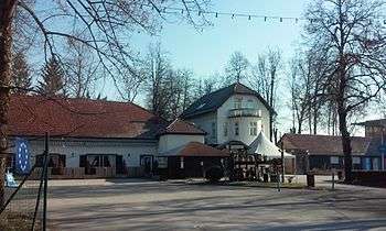
Ježica started to develop at the end of the 19th century, when people from Ljubljana visited the town, known for its famous inns. During that time, Tyršer road (today Dunajska road) led here, decorated with linden. Another magnet for the people of Ljubljana was the Sava river, suitable for refreshing.[7] This place became even more popular when a spa was built. During the war tourism died. After 1965, when an autocamp was established, tourists started to return. Unlike before, the tourists were mostly foreign. But they only came because of the vicinity of Ljubljana, which was their main goal. In 1984 more than 25,000 guests visited the municipality of Bežigrad, where Ježica had most of its accommodations. This ranked the municipality in 18th place, among other municipalities in Slovenia, comparing the number of tourists. Today's type of tourists stays the same as they were in the past (after 1965). They are mostly foreigners visiting Ljubljana, while Ježica doesn't interest them. A new tourist acquisition is the new hotel, part of the Florjančkov hram complex. Unfortunately, the architecture of the new hotel isn't appropriate for this surrounding and represents an improper case of urban architecture.
Inns
What made Ježica so special in the past were the famous inns, visited by people of Ljubljana, mostly in the weekends. At the beginning of the 20th century some of the most popular inns were Tavčar (pri Tavčarju), Florjanček (pri Florjančku), Štern (pri Šternu), Aleš (pri Alešu) and Angelca (pri Angelci). Today's inns that still exist here are only faint shadows of those in the past. Only the Tavčar, Štern and Florjanček inns exist; the former Aleš and Angelca inns still stand but don't operate as inns anymore.
- Tavčarjev dvor – built in 1906, a successor of an old inn with the same name that operated in today's school car park next to it. The name derives from the German Count Tavčar. His inn was formally called Tavčar hoff or Tauzherhof. The inn that operates today was popular among residents of Ljubljana, visiting in the weekends when coming to swim in the Sava river. During World War II, Germans had their quarters here for bridge defense. After the war police and later residents stayed in this house. It was nationalized and later, catering company Bežigrad became the manager. Now it has been in private ownership for the past few decades. Its glory is gone and today passersby only stop by to get a drink.
- Restaurant Štern – built in 1928. The first owner was the vine seller Stern, from upper Carniola. During World War II, the Italian army stayed here. After the war it was nationalized and became the restaurant and spa of Municipality Bežigrad. The restaurant still operates today. It serves Slovenian and other dishes.[12]
- Florjančkov hram – has existed since 1792, formally named Pri Florjančku (at Florjanček). It was an old furman restaurant. Fran Levec, a famous historian and literature critic, was born here in 1846. France Prešeren, a famous Slovenian poet, liked to visit Florjanček in the past. It was known for good local food, produced on their farms. Tradition is their priority even today, so Slovenian food is the main offer.[13]
- Horses pub – A relatively modern pub, established in 1997 that became quite popular among people.
Spa and resort
The history of the spa began in the 1930s, when the wine seller Stern built the first building and inn which still stands today. Next to them he built a wardrobe and showers. A horse stable also stood here. Soon he built wooden pools with sand. They served for people with rheumatism. The war suppressed the development of the spa and it started to decay. After the war it was nationalized. The new manager made it a recreation center for Ježica. In 1965, an autocamp was established near the spa with a camping site, resort houses, bungalows, summer and winter swimming pools and a bowling alley. After 1991 it began to be denationalized, and no one owned the area, which led to the decay of the resort. Nevertheless, four swimming pools stood here until 2005, which were very popular among locals. In 2005 the swimming pool was renovated, new hydromassage pools were built and the spa was renamed in Laguna Ljubljana city beach. Since then, the prices went up and the spa became the most expensive swimming resort in Ljubljana.[12]
Holidays
- Slovene quintain – A form of quintain known as štehvanje was introduced to Ježica and neighboring villages in 1935. This Slovenian competition originates from the Gail Valley, and the event is held in June.
- Gasilska veselica (Firefighters party) – These parties are common in Slovenia for every village or town. Ježica is no exception. It has been organized continuously since 2012 after many years. The party is usually organized in May.
- 7 September – memorial day, celebrated every year on 7 September, near the street of the same name, in memory of local activists, the first to resist the fascism in Ježica during World War II.
Sava river
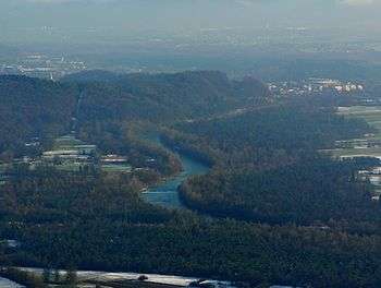
The Sava river had a big influence on people that lived here in the past. It was noted in the Roman times as the most sufficient place to build a bridge. The reason is that a terrace called Ježa is close to the rocky hill Tabor, that presents a labile surface, which is appropriate for building a bridge. The river was different from today. Its winding stream was typical for Sava on Ljubljana field. It was disturbing the gravel and generated large gravel bars. Floods were common on the land under Ježa. This is the land where we can find cultivated fields and lower part of the village today. On the Franciscan cadastre (year 1825), two bridges, higher than the main bridge over Sava, are seen. Both served as bridges over the two Sava branches. One is made of steel, and it's hard to imagine that Sava was higher than today. It looked like that until the 19th century, when regulation began. The biggest regulation of the river was made in 1895, from Tacen to Šentjakob. Work ended in 1908. Soon the river showed its power. The river stream became much stronger because an increase of inclination. Erosive strength also became more powerful. The river returned to its old condition in 1935, and 90% of human work was ruined. Another problem of regulation was groundwater, which made water levels fall 7 meters (23 ft) at the Kleče water station.[14]
In 1953 a hydroelectric power plant was built in Medvode. Because of that, the river bed was deepening until it reached carbon rock base, which is most noticeable in Ježica. The reason is that HE Medvode stopped the gravel in the upper part of the river. The gravel in the lower part of the river was carried downstream, so now carbon rock is seen by the river.[15] The flooding surface around Ježica is now lost and water flows to the lower parts of Slovenia and Croatia where it makes problems with flooding.
The Sava river shores were popular among people in the past. In the 19th century, shores in Ježica were a popular recreation area. The quality of the water today is bad, so it is not recommended to swim; however, conditions today are much better than in the second half of the 20th century. The city Municipality of Ljubljana has plans to improve water quality so it will be appropriate to swim again. Swimming places are planned in Ježica.[16] Another problem are wastes, an endless case with no solutions and motivation to solve this problem. Criminal and sexual harassment is also reported often. Shores north of Črnuče bridge became known as gay beach and are known for sexual adventures.
Church
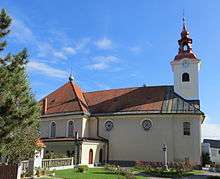
The church in Ježica is dedicated to Saint Cantianus and was built on the site of a medieval predecessor mentioned in written records in 1526. The new church was built from 1792 to 1802, and an east addition was built in 1938 based on plans by the architect Vinko Glanz (1902–1977). The painting of the Holy Cross is an 1802 work by Andreas Herrlein (1739–1837), the Stations of the Cross are the work of Leopold Layer (1752–1828), the pulpit painting by Mirko Šubic (1900–1976), and the mosaic by Stane Kregar (1905–1973). The main altar was designed by the architect Ciril Zazula (1924–1995) and the side altars by Janko Omahen (1898–1980).[1] Ježica was originally part of the proto-parish of Saint Peter in Ljubljana.[6]:349 It became a quasi-parish in 1787 and was elevated to a parish in 1850. There is an old wayside shrine below the church.[1]
Other cultural heritage
- Bunker no. 1 stands on the right bank of the Sava River. It was built by the Yugoslav Army between 1939 and 1940.[17]
- Bunker no. 2 stands near the railway bridge on the right bank of the Sava River. It was built by the Yugoslav Army between 1939 and 1940. It is the largest of the bunkers that protected the passage across the river.[17]
- Bunker no. 3 stands on the right bank of the Sava River. It was built by the Yugoslav Army between 1939 and 1940.[17]
- The house at Vienna Street (Dunajska cesta) no. 254 is a single-story building. In the past it was the Aleš Inn (pri Alešu). It has a symmetrical double-pitched roof and two dormers. The year 1850 is carved into the door frame.[17]
- The driving school building was a toll house in the past, where tolls were collected along the road from Vienna to Trieste. The building was much smaller until the mid-19th century, when it was remodeled in the form it has today.[17]
- There is a small bridge on Vienna Street (Dunajska cesta), near the Florjanček Inn (Florjančkov hram). It stands on a former branch of the Sava River that filled during flooding.
- A plaque was installed in 1974 at the spa to commemorate the 1515 peasant revolt.[18]
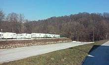
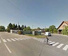
Gallery
 Bridge on the Sava River branch
 Bunker no. 2
 The former Aleš Inn
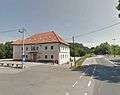 The Ježica driving school
Notable people
Notable people that were born or lived in Ježica include:
- Jurij Japelj (1744–1807), first parish priest, translator, and philologist[1]
- Franc Levec (1846–1916), literary historian, linguist, editor of the journal Ljubljanski zvon[1]
- Alojzij Merhar (a.k.a. Silvin Sardenko) (1876–1942), poet, writer, playwright, and editor[6]:349
- Jožef Prešern (1752–1835), parish priest and uncle of the poet France Prešeren[1]
- Janez Pucelj (a.k.a. Ivan Pucelj)[6]:220 (1890–1964), poet and translator[1]
- Matija Sitar (1860–1903), art historian[1]
- France Škerl (1909–1985), historian[1]
- Feliks Skerlep (1904–1980), horticulturalist[1]
References
- 1 2 3 4 5 6 7 8 9 10 11 12 13 14 15 Savnik, Roman, ed. 1971. Krajevni leksikon Slovenije, vol. 2. Ljubljana: Državna založba Slovenije, pp. 350–351.
- ↑ Intelligenzblatt zur Laibacher Zeitung, no. 141. 24 November 1849, p. 21.
- 1 2 Leksikon občin kraljestev in dežel zastopanih v državnem zboru, vol. 6: Kranjsko. 1906. Vienna: C. Kr. Dvorna in Državna Tiskarna, p. 108.
- ↑ Ljubljana municipal site
- ↑ Snoj, Marko. 2009. Etimološki slovar slovenskih zemljepisnih imen. Ljubljana: Modrijan and Založba ZRC, p. 179.
- 1 2 3 4 5 Krajevni leksikon Dravske Banovine. 1937. Ljubljana: Zveza za tujski promet za Slovenijo.
- 1 2 3 4 5 6 7 8 9 10 11 12 13 14 15 16 17 18 Čerin, Miha. 1985. Ljubljansko posavje v ljudski revoluciji. Ljubljana: Občinska konferenca SZDL Ljubljana-Bežigrad.
- 1 2 Spremembe naselij 1948–95. 1996. Database. Ljubljana: Geografski inštitut ZRC SAZU, DZS.
- ↑ Zupanc, Jernej. 2013. O gostilnah, ki jih ni več. Naš Bežigrad.
- ↑ Odlok o občinskem podrobnem prostorskem načrtu za dele območij urejanja BS 4/1 Ruski car, BS 4/2 Stoţice, BS 4/3 Jeţica in BS 4/4 Mala vas (Uradni list RS, št. 53/09-2619 in 78/10-4264)
- ↑ Na Dunajsko cesto proti njeni širitvi. Delo.
- 1 2 http://www.gostilna-stern.si/o_nas/zgodovina.html
- ↑ http://www.florjanckovhram.si/en/our-story/
- ↑ Radinja, Darko. 1951. Sava na Ljubljanskem polju, Geografski vestnik.
- ↑ Kopač, Ana. 2015. Prostorski učinki gradnje hidroelektraren na srednji Savi: odsek Tacen - Zalog. Zaključna seminarska naloga. Univerza v Ljubljani. Filozofska fakulteta, Oddelek za Geografijo. Ljubljana.
- ↑ Poročilo o delu inštituta za vode Republike Slovenija. 2012. Projekt I/4 Priprava in zagotovitev strokovnih podlag za izvajanje kopalnih direktiv (76/160/EGS inn 2006/7/ES) Letno poročilo. Ljubljana.
- 1 2 3 4 5 Slovenian Ministry of Culture register of national heritage
- ↑ Slovenian Ministry of Culture register of national heritage reference number ešd 5737
External links
 Media related to Ježica at Wikimedia Commons
- Ježica on Geopedia