Kamnik
| Kamnik | |
|---|---|
| Town | |
|
The southern portion of the old part of Kamnik | |
 Kamnik Location of the Town of Kamnik in Slovenia | |
| Coordinates: 46°13′32.69″N 14°36′43.14″E / 46.2257472°N 14.6119833°ECoordinates: 46°13′32.69″N 14°36′43.14″E / 46.2257472°N 14.6119833°E | |
| Country |
|
| Government | |
| • Mayor | Marjan Šarec |
| Area | |
| • Total | 9.1 km2 (3.5 sq mi) |
| Population (2012)[1] | |
| • Total | 13,608 |
| • Density | 1,501/km2 (3,890/sq mi) |
| Time zone | CET (UTC+01) |
| • Summer (DST) | CEST (UTC+02) |
.jpg)
Kamnik (pronounced [ˈkaːmnik]; German: Stein[2] or Stein in Oberkrain) is a town in northern Slovenia. It is the central settlement of the Municipality of Kamnik. It encompasses a large part of the Kamnik Alps and the surrounding area. The town of Kamnik has ruins of two castles as well as many examples of historical architecture.
History
The name Kamnik was first mentioned in the 11th century. The first time it was mentioned as a town was in 1229, when it was an important trading post on the road between Ljubljana and Celje. This makes the town one of the oldest in Slovenia. In the Middle Ages, Kamnik had its own mint and some aristocratic families among its residents. The town was among the most influential centers of power for the Bavarian counts of Andechs in the region of Carniola at the time. The only remnant of the Bavarian nobility are the two ruined castles which are both strategically built on high ground near the town center. The Franciscan monastery built in the town itself is a testament to its importance. The building is well preserved and has undergone extensive renovation in recent years.
Historical suburbs of the town include Šut(i)na (German: Schutt[2]), Na Produ (Slovene: Na produ), Novi Trg (Novi trg, German: Neumarkt[2]), Pred Mostom (Pred mostom, German: Vor der Brücke[2]), Graben, and Podgoro. In 1934 the following formerly independent settlements were annexed by Kamnik: Fužine (German: Fuschine[2]), Žale (in older sources also Žalje,[2] German: Sallenberg[2]), Zapr(i)ce (German: Steinbüchel[2]), Kratno, Pugled, Zgornje Perovo (German: Oberperau[2]), Spodnje Perovo (German: Unterperau[2]), Bakovnik, and the lower part of Mekinje.[3]
Most of the old town center is built in an Austro-Hungarian style. Most of the facades have been renovated in recent years but the process is still ongoing.
Mass grave
Kamnik is the site of a mass grave from the period immediately after the Second World War. The Cuzak Meadow Mass Grave (Slovene: Grobišče Cuzakov travnik) is located in the southeast part of the town, in a grassy area encircled by a road on the premises of the Svit factory. The grave contains the remains of several hundred soldiers and civilians, mostly Croats but also some Serbs, that were murdered on 11 May 1945.[4][5][6][7]
Notable natives
- Fran Albreht, author
- France Balantič, poet
- Jurij Japelj, philologist
- Rudolf Maister, military leader
- Jakob Savinšek, sculptor and illustrator
- Bojan Kraut, engineer
Gallery
 Southern part of Kamnik with suburbs
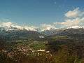 Kamnik's northern suburbs with the Kamnik–Savinja Alps in the background
 House where Rudolf Maister was born
 A copper engraving of Kamnik in 1689
 Little Castle
 Zaprice Castle
 Franciscan monastery
References
- ↑ "Kamnik, Kamnik". Place Names. Statistical Office of the Republic of Slovenia. Retrieved 29 February 2012.
- 1 2 3 4 5 6 7 8 9 10 Leksikon občin kraljestev in dežel zastopanih v državnem zboru, vol. 6: Kranjsko. 1906. Vienna: C. Kr. Dvorna in Državna Tiskarna, pp. 26–27.
- ↑ Savnik, Roman, ed. 1971. Krajevni leksikon Slovenije, vol. 2. Ljubljana: Državna založba Slovenije. pp. 178–179.
- ↑ Cuzak Meadow Mass Grave on Geopedia (Slovene)
- ↑ Komisija za reševanje vprašanj prikritih grobišč. 2008. Poročilo Komisije vlade Republike Slovenije za reševanje vprašanj prikritih grobišč: 2005-2008. Ljubljana, Družina, p. 1897.
- ↑ Ferenc, Mitja, & Ksenija Kovačec-Naglič. 2005. Prikrito in očem zakrito: prikrita grobišča 60 let po koncu druge svetovne vojne. Celje: Muzej novejše zgodovine Celje, p. 118.
- ↑ Ferenc, Mitja, & Želimir Kužatko. 2007. Prikrita grobišča Hrvatov v Republiki Sloveniji. Ljubljana: Inštitut za novejšo zgodovino.
External links
| Wikimedia Commons has media related to Kamnik. |
-
 Kamnik travel guide from Wikivoyage
 - Kamnik, official page of municipality (in Slovene)
- Kamnik (map). Geopedia.si.
- Kamnik: virtual panoramas. Burger.si.
