Itapemirim, Espírito Santo
| Itapemirim Município de Itapemirim | |||
|---|---|---|---|
| Municipality | |||
|
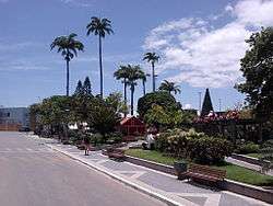
Street scene in Itapemirim | |||
| |||
| Motto: "Cuidar de você, nossa principal missão" | |||
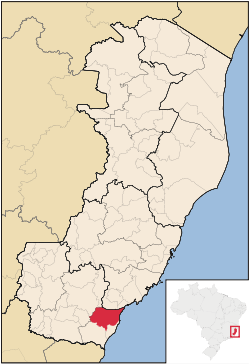 Location of Itapemirim in Espírito Santo | |||
 Itapemirim Location of Itapemirim in Brazil | |||
| Coordinates: 21°00′40″S 40°50′02″W / 21.01111°S 40.83389°WCoordinates: 21°00′40″S 40°50′02″W / 21.01111°S 40.83389°W | |||
| Country | Brazil | ||
| Region | Southeast | ||
|
| |||
| Founded | June 27, 1815 | ||
| Government | |||
| • Mayor | Viviane Peçanha (PSDB, 2013-2016) | ||
| Area | |||
| • Total | 561.87 km2 (216.94 sq mi) | ||
| Population (2014) | |||
| • Total | 33,952 | ||
| • Density | 60/km2 (160/sq mi) | ||
| Demonym(s) | Itapemirinense | ||
| Time zone | BRT (UTC-3) | ||
| Website |
www | ||


Itapemirim is a municipality located in the Brazilian state of Espírito Santo. Its population was 33,952 (2014) and its area is 561.87 square kilometres (216.94 sq mi) with a population density of 60 inhabitants per square kilometer.[1]
The municipality contains part of the protected area of the Frade e a Freira Natural Monument.[2]
References
- ↑ "Itapemirim" (in Portuguese). Brasília, Brazil: Instituto Brasileiro de Geografia e Estatística. 2015. Retrieved 2015-08-23.
- ↑ Monumento Natural O Frade e a Freira (in Portuguese), Secretário de Meio Ambiente, Espírito Santo, retrieved 2016-05-06
Capital: Vitória | ||||||||||||||||
| Mesoregion Central |
|  | ||||||||||||||
| Mesoregion Litoral Norte |
| |||||||||||||||
| Mesoregion Noroeste |
| |||||||||||||||
| Mesoregion Sul |
| |||||||||||||||
This article is issued from Wikipedia - version of the 5/6/2016. The text is available under the Creative Commons Attribution/Share Alike but additional terms may apply for the media files.