Vitória, Espírito Santo
| Vitória | |||
|---|---|---|---|
| Municipality | |||
| Município de Vitória Municipality of Vitória | |||
|
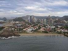
From the top, left to right: Canto's Beach, Boi's Island, Third Bridge, Anchieta Palace, Suá's Beach, and Valentine's Plaza (at night) | |||
| |||
|
Nickname(s): Honey Island Sun City Vix | |||
 Location in the Espírito Santo | |||
 | |||
| Country |
| ||
| Region | Southeast | ||
| State |
| ||
| Founded | September 8, 1551 | ||
| Government | |||
| • Mayor | Luciano Rezende (PPS) | ||
| Area | |||
| • Municipality | 93.381 km2 (36.055 sq mi) | ||
| • Metro | 3,204.26 km2 (1,237.17 sq mi) | ||
| Elevation | 4 m (13 ft) | ||
| Population (355.875 (2015 estimate)) | |||
| • Municipality | 355.875 | ||
| • Density | 3,546.7/km2 (9,186/sq mi) | ||
| • Metro | 1,857,616 | ||
| Time zone | UTC-3 (UTC-3) | ||
| Postal Code | 29000-000 | ||
| Area code(s) | (+55) 27 | ||
| Demonym | vitoriense | ||
| Website | Vitória, Espírito Santo | ||


Vitória (Portuguese pronunciation: [viˈtɔɾjɐ], Victory), spelled Victória until the 1940s, is the capital of the state of Espírito Santo, Brazil. It is located on a small island within a bay where a few rivers meet the sea. It was founded in 1551. The city proper 93 square kilometres (36 square miles) has a population of 358,875 (2015) whilst the Greater Vitória metropolitan area has a population of more than 1,857,616 (2013), the 14th largest in Brazil.
Vitória is surrounded by the Vitória's Bay. It is an riverine island. In addition to the main island, Vitória, are part of the municipality another 34 islands and a mainland portion, a total of 93.381 square kilometres (36.05 square miles). Originally there were 50 islands, many of which were added through landfill to the largest island.
In 1998, the United Nations rated Vitória as the fourth best state capital in Brazil to live in, rating cities on health, education, and social improvement projects. Among the Brazilian capitals, Vitória has the current second best human development index (HDI) (after Florianópolis) according to a research from Getulio Vargas Foundation. It was considered the 4th best city to live in Brazil by United Nations in 2013 (behind São Caetano do Sul, Águas de São Pedro and Florianópolis) and the highest gross domestic product per capita.
Vitória has two major ports: the Port of Vitória and the Port of Tubarão. These ports are part of the largest port complex of the country, which are considered the best in quality of Brazil.
Blessed by an incomparable natural beauty, the city is located on a rocky massif, with the central Morro da Fonte Grande (Big Fountains's Hill) and Pedra dos Dois Olhos (Stone with Two Eyes).
The city, which lies on the coast, has proximity to the region of mountains of Espírito Santo .
The city manages the Trindade and Martim Vaz islands, 1,100 kilometres (680 miles) off the coast, which are important meteorological bases because of its strategic position: located in an area of dispersion of air masses.
Vitória is a great tourism destination for those who want to see a beautiful scenery and a city with good life quality.
Eurico de Aguiar Salles Airport connects Vitória with many Brazilian cities.
The city is home to the Federal University of Espírito Santo (UFES).
Geography
It has a very jagged coastline and in addition to it, Vitória has 40% of its area covered by hills, making the growth of new urbanized areas in the city harder, and while the city proper has upscale neighborhoods, by other side, the neighbouring municipalities in the metropolitan region, with a notably lower HDI, have more poor suburban areas (in Brazil, the affluent neighbourhoods tend to be relatively close to the city center).
This formation of a "core of good-looking, affluent districts" close to the historical center isolated by a mountain range from the middle and lower class suburbs is evocative of how Rio de Janeiro's spatial segregation is organizated, although lower class poorly urbanizated neighbourhoods in Vitória's highlands are not as famous, if one can say that favelas like what is found soon after Rio de Janeiro's affluent neighbourhoods close to the center even exists (it is already present in Vitória metropolitan region, but probably not the city proper).
Relief
The relief of the islands is an extension of the continent, whether granite, surrounded by the sea and native Brazilian restinga-mangue (dunes and sandbanks' bush and mangroves i.e. immediate coastline flora) vegetation. The central massif of the island of Vitória, Morro da Fonte Grande, has an altitude of 308.8 m and the main granitic outcrops are Pedra dos Dois Olhos, with 296m, and Morro de São Benedito, with 194m of altitude. Vitória's highest point is Pico do Desejado, located in the Trindade Island, with 601m of altitude, eleven hundred kilometers away from the mainland coastline.
Climate
| Vitória | ||||||||||||||||||||||||||||||||||||||||||||||||||||||||||||
|---|---|---|---|---|---|---|---|---|---|---|---|---|---|---|---|---|---|---|---|---|---|---|---|---|---|---|---|---|---|---|---|---|---|---|---|---|---|---|---|---|---|---|---|---|---|---|---|---|---|---|---|---|---|---|---|---|---|---|---|---|
| Climate chart (explanation) | ||||||||||||||||||||||||||||||||||||||||||||||||||||||||||||
| ||||||||||||||||||||||||||||||||||||||||||||||||||||||||||||
| ||||||||||||||||||||||||||||||||||||||||||||||||||||||||||||
The city's climate is tropical, with average annual temperature of 23 °C (73 °F) and the occurrence of rainfall specially in the months from October to January. Temperatures can vary greatly in winter and can reach 30 °C (86 °F) in times of drought but 12 °C (54 °F) when cold fronts occur followed by an abnormally cold temperature of the ocean. The highest absolute maximum temperature ever recorded in the city was 39.6 °C (103.3 °F) (INMET) on February 25, 2006 and the minimum was less than 9 °C (48 °F) because of the cold Falklands oceanic current.
Vitória shares with Rio de Janeiro the position of the Brazilian capital with lowest rates of rainfall at approximately 918 millimetres (36.1 in) annually. Vitória is also the city that presents the lowest temperature range in practically all the state of Espírito Santo, as result of both its oceanic climate, given by location, and the protection that the mountains create from the major weather changes influenced by air masses.
Vitória is one of the hottest cities in the state of Espírito Santo, due to atmospherical pollution and the large cluster of buildings, in addition to several mountains on the island, which block the south wind, which traditionally occurs on cold days in the state. This causes the minimum of the city being 2 °C (3.6 °F) warmer than the average in the state. Another contributing factor is that the level of rainfall in the city is lesser than Espírito Santo's average as a whole, by about 350 millimetres (13.8 in). This thermal variation can be easily noticed by comparing the temperatures of Vitória with the nearby town of Vila Velha, noted in all seasons, specially in winter, the minimum of Vila Velha is 1 °C (34 °F), 3 °C (5.4 °F) lower than in Vitória.
Coastline
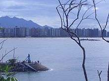
Surrounded by the Bay of Vitória, the main island has many beaches, mangroves, granite formations and many smaller islands. Praia de Camburi, Ilha do Boi, Praia do Canto, Curva da Jurema, Praia da Costa and Praia de Jacaraipe are just a few of the beautiful beaches along Vitoria and nearest cities.
History

Vila Velha, which was the capital of Brazilian Espírito Santo captaincy, found itself in constant attacks from the Tupi-Guarani-speaking and possibly some Macro-Jê-speaking indigenous peoples, the French and the Dutch. The Portuguese then decided to move away the capital and chose an island near the mainland, called by some of the native peoples Guanaani Island. Vila Nova do Espírito Santo, as it was called, was founded on September 8, 1551 and later renamed Vitória in memory of the victory in a great battle led by the donee of the captaincy, Vasco Fernandes Coutinho, against Goytacaz Amerindians.
Until the last century, the limits of the current capital of Espírito Santo were Fort São João, where is currently located the Club de Regatas Saldanha da Gama, near the city center, and the hill where sits the actual Santa Casa de Misericórdia hospital, in Vila Rubim. The city was built on the highlands, which originated several narrow streets. The lowlands were under attacks and because of that a number of fortresses were built in the coastline.
On February 24, 1823 (March 17, 1829?) the town of Vitória became a city, but its insular isolation prevented its development. From the year 1894 on, with the coffee cycle, many landfills were implemented in the lower parts of the city, changing the shape of the island and urbanizing it. Several new neighbourhoods were thus inhabited and public stairs built to connect them with the higher grounds. Ancient houses were demolished. Moreover, sanitation was improved. In 1927 the bridge that connected the island to the mainland was opened and 1941 the first harbour pier.
The port had an important development. Wide avenues were opened over landfills. With these changes the city became the largest urban space of the Espírito Santo state, a metropolis. In 1970 the Vitória Harbour rose to one of the most important in the country, and the city began its industrialization process. The modernization of the island led to the disappearance of almost all traces of the Colonial and Imperial Brazilian époques.
Demographics

According to the IBGE of 2013, there were 348,265 people residing in the city. The racial makeup of the city was 52.33% White, 38.46% Pardo (Mixed-Race), 7.43% Black, 0.78% Asian or Amerindian.[1]
Vitória is the second Brazilian capital with the best quality of life, according to research at the Getúlio Vargas Foundation. This same research institution also claims that Vitória is the 9th best city in Brazil to work. The capital of the Espírito Santo has the highest per capita income among the capitals of Brazil.
- GDP per capita (2007): 60592.00 (1st place among the capitals)
- Life Expectancy (years) at birth: 70.74 (4th place among the capitals)
- IDHM R-index of income: 0.858 (3rd position among the capitals)
- IDHM E-Education Index: 0.948 (3rd position among the capitals)
- IDHM-L Index Longevity: .762 (4th place among the capital)
- ICH index of deprivation in the Provision of Essential Services Housing: 0.882
- Adult literacy rate: 95.48% (5th position among the capitals)
- Average ENEM 2007: 60.225 (1st place among the capitals of Brazil)
- Gross rate of school attendance: 93.36% (3rd position among the capitals)
- Gini Index : 0.61
- Highest HDI between the capitals of the Southeast and third largest among the capital (0.856)
- Number of voters: 237 554
- Annual population growth rate: 2.36%
- Best capital for young start career
- Ninth best city to work
- Vitória Airport is the 14th in passenger movement in Brazil, and it embarked or disembarked 1,661,192 passengers in 2006. It is the 14th in cargo, and transported 13,023,544 kilograms in 2006.
- Vitória has the largest port in handling a ton of Brazil
- Fleet of vehicles: 120,826
- Smaller population of the capitals of Southeastern
Religion
| Religion | Percentage | Number |
|---|---|---|
| Catholic | 63.36% | 185,211 |
| Protestant | 22.18% | 64,846 |
| No religion | 10.53% | 30,791 |
| Spiritist | 2.04% | 5,975 |
Economy
Vitória's economy is based on port activities, active trade, industry, and also providing services to tourism. The capital of Espírito Santo has two ports that are the most important of the country: Port of Vitória and the Port of Tubarão. The most important industries are global steelmaker ArcelorMittal Tubarão (formerly CST) and mining company Vale (formerly CVRD / Companhia Vale do Rio Doce.
Trade
The main shopping center in Vitória is the Shopping Vitória, featuring over 400 shops, a large food court and a cineplex. There is also the Shopping Norte Sul, with 99 stores, the Shopping Centro da Praia, Shopping Boulevard, among others.
Education
Portuguese is the official national language, and thus the primary language taught in schools. A secondary language is also required as part of the official curriculum for both elementary schools and high school. The second most taught language is English, followed by Spanish, French and Italian.
Curiously, within the state of Espírito Santo, the German language (especially the Pomeranian language variety) has probably as many speakers as the French and Italian languages, although it is not available as part of the official curriculum for most of schools.
Educational institutions
- Universidade Federal do Espírito Santo (UFES)
- Instituto Federal de Educação, Ciência e Tecnologia do Espírito Santo (IFES) – a.k.a. Centro Federal de Educação Tecnológica do Espírito Santo (CEFET-ES) / Escola Técnica Federal do Espírito Santo (ETFES)
- Universidade Vila Velha (UVV)
- Escola Superior de Ciências da Santa Casa de Misericórdia de Vitória (Emescam)
- Faculdade de Música do Espírito Santo (FAMES)
- Faculdade Brasileira de Ensino (UNIVIX)
- Faculdade Cândido Mendes de Vitória (FCMV)
- Faculdades Integradas Espírito-Santenses (FAESA)
- Faculdades Integradas de Vitória (FDV)
- Faculdade Estácio de Sá de Vitória (Fesv)
- Associação Vitoriana de Ensino Superior (Favi)
- Faculdade Metropolitana de Vitória (Metropolitana)
- Faculdade Batista de Vitória (Fabavi)
- Faculdade de Ciências Econômicas de Vitória (Facev)
- Fundação Capixaba de Pesquisa em Economia, Contabilidade e Finanças (FUCAPE Business)
It formerly hosted the Vitória Japanese School (ヴィトリア日本人学校 Vitoria Nihonjin Gakkō), a Japanese international school.[3]
Transportation
_Brazil_01529.JPG)
Airport
Eurico de Aguiar Salles Airport (Goiabeiras) is located on a land plot of just over 5.2 million square meters. Since construction of its first step, finished in 1946, Vitória Airport has undergone several expansions and modernizations, but current demand has surpassed its capacity of 2.9 million passengers a year. The passenger terminal is air conditioned, with a constructed area of nearly 17,000 square meters, a check-in concourse, 25 check-in counters and boarding and arrival lounges. The recent construction of new aircraft parking boxes on the aprons has improved the airport's operational efficiency.
In 2012, more than 3.7 million passengers used the airport, and in 2013 this rose to almost 4 million. Vitória is one of the 32 airports in the Infraero network that has a cargo terminal. In May 1999, the first direct international freight connection started between Vitoria and the United States (Miami) began operating to Vitória, facilitating imports to the state of Espírito Santo. Today there are five such flights a week.
Public Transportation
Vitoria has two urban transportation systems.
- The first one, which only works in the city, known by the locals as "verdinhos" because the colors of the bus, the municipal fleet is divided into three bus companies operating 52 conventional lines and 2 selective lines with air conditioning. The passages payment system is electronic ticketing and has service in all districts of the city.
- Transcol system, linking the capital to other cities of Vitoria, and the lines run along major corridors such as Victoria Av and Beira Mar Av. Some neighborhoods of the city, get out of the axes of the main avenues have specific lines, as Jardim Camburi, which is linked to the Carapina Terminal and Laranjeiras, in the municipality of Serra, through 800 and the Grande Sao Pedro and Grande Santo Antonio line, which are served by lines 518 and 535 and connected to Ibes terminals (Vila Velha) Jardim America (Cariacica), Campo Grande (Cariacica) and Carapina (Serra). It features integration system through bus terminals that are scattered strategic points of the metropolitan area. The state capital, however, no longer has the Transcol system terminals since the extinction of the Terminal Don Bosco in 2009.
Airlines and destinations

Highways
The main access roads are the BR-101, a motorway linking the Brazilian south and northeast with the Metropolitan Region of Greater Vitória, the BR-262 that connects the Central region with Vitória and the Rodovia do Sol (Sun Motorway) – ES-060 which links the local coastal regions.
Ports
The city has two ports: the Port of Vitória and the Porto do Tubarão.
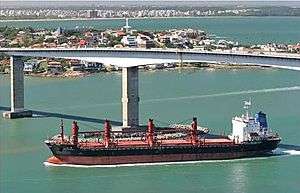
The Porto de Vitória is the most difficult port for ships to access in all of Brazil. The Bay of Vitória is extremely narrow, with stones and mountains that complicate the access by freighters and maritime cruisers to the docks. Ships, cars, and people all compete for space. There are restrictions on traffic, limiting the use of the port. Today the port is mostly used by cruise ships and for the repair of ships and oil platforms.
The Port of Tubarão was designed in the 1960s by Companhia Vale do Rio Doce when the Port of Vitória began showing signs of saturation. It has far easier access to the sea. From its opening in 1966, its capacity has gradually increased, reaching 80 million tonnes/year in the last decade. Although originally created to export iron ore, in recent years it has added silos for storing grains and soybean meal. The port is located at one end of Camburi Beach.
Railways
The Vitória-Minas Railway, which carries cargo from the Central Region, also carries passenger from Vitória to Belo Horizonte.
Bridge
The Deputy Darcy Castelo de Mendonça Bridge, also known as the Third Bridge (Portuguese: Terceira Ponte), is the second tallest bridge in Brazil, connecting and reducing the distance between the cities of Vila Velha and Vitória.
Sports
Football
There are four professional football teams in the city, Rio Branco Atlético Clube, usually known simply as Rio Branco, Espírito Santo Futebol Clube, usually known simply as Espírito Santo, Doze Futebol Clube, usually known simply as Doze, currently playing in Campeonato Capixaba first level. And Vitória Futebol Clube (ES), usually known simply as Vitória (or as Vitória-ES), currently playing in Campeonato Capixaba second level.
Kitesurf
Nice place for the practice of kitesurfing. It has constant northeast wind and is safe as its inside the bay.
Twin towns – Sister cities
Main sights

- Penha Convent (Convento da Penha) - Although located in Vila Velha, it is widely recognized as a city landmark.
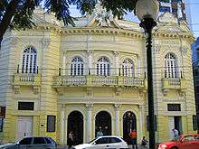
- Carlos Gomes Theatre (Teatro Carlos Gomes)
- The Metropolitan Cathedral (Catedral Metropolitana)
- Old Town Houses (Cidade Velha)
- Costa Pereira Square (Praça Costa Pereira)
- The Chapel of Santa Luzia (Capela de Santa Luzia)
- São Gonçalo Church (Igreja de São Gonçalo)
- Anchieta Palace (Palácio Anchieta)
- Domingos Martins Palace (Palácio Domingos Martins)
- The Monastery of São Francisco (Monastério de São Francisco)
- Rosário Church (Igreja do Rosário)
- Santo Antônio Sanctuary (Santuário de Santo Antônio)
Other cities in the greater Vitória Metropolitan Region
References
- ↑ Síntese de Indicadores Sociais 2000 (PDF) (in Portuguese). Vitória, Brazil: IBGE. 2000. ISBN 85-240-3919-1. Retrieved 2009-01-31.
- ↑ Religion in Vitória by IBGE
- ↑ "過去に指定・認定していた在外教育施設" (Archived 2015-01-14 at WebCite). Ministry of Education, Culture, Sports, Science and Technology. Retrieved on January 15, 2015. "ヴィトリア日本人学校 (小学部及び中学部) ブラジル国ヴィトリア"
- 1 2 3 4 "Redes de Cidades :: Prefeitura :: Prefeitura de Vitória". www.vitoria.es.gov.br. Retrieved 2015-09-21.
External links
- Vitória's Municipal Page (in Portuguese)
- Vitória's Government Page - Tourism
- Hotel bookings at Vitória (in Portuguese)
- IBGE statistics for many Brazilian cities (in Portuguese)
- Images Google Maps of Vitória - ES
- Portal with Information about Vitória and Espírito Santo
- The Best of Vitória - Guide (in Portuguese)
| ||||||||||||||||||||||||||||||||||||||||||||||||||||||||||||||||||||||