Irwin River
| Irwin River | |
|---|---|
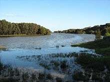 Irwin River wetlands near Dongara, Western Australia | |
| Country | Australia |
| Basin | |
| Main source |
Near Pindar 326 metres (1,070 ft)[1] |
| River mouth |
Arurine Bay, between Port Denison and Dongara Sea level |
| Basin size | 6,071 square kilometres (2,344 sq mi)[2] |
| Physical characteristics | |
| Length | 140 kilometres (87 mi)[3] |
The Irwin River is a river in the Mid West of Western Australia. It was named on 9 April 1839 by the explorer George Grey, while on his second disastrous exploration expedition along the Western Australian coast, after his friend Major Frederick Irwin, the Commandant of the Swan River settlement, and later acting Governor of Western Australia from 1847 to 1848.[4]
The headwaters of the Irwin are located below Canna near Pindar. The river flows west until discharging into Arurine Bay near Dongara.
The river has four tributaries: Lockier River, Sand Plain Creek, Nangetty Creek and Mullewa Creek.
The river occasionally floods as it did in 1945 following a severe storm that swept over the area. The river broke its banks and caused extensive damage including the loss of 450 sheep that were swept away from a farm that straddled the river.[5]
References
- ↑ "Bonzle Digital Atlas – Map of Irwin River, Western Australia". 2008. Retrieved 12 July 2016.
- ↑ "Where the River meets the Sea – Estuaries of the Northern Agricultural Region" (PDF). 2005. Archived from the original (PDF) on 20 July 2008. Retrieved 17 October 2008.
- ↑ Western Australian Land Information Authority. "History of river names". Archived from the original on 16 February 2015. Retrieved 7 September 2011.
- ↑ Grey, George (1841). Journals of two expeditions of discovery in North-West and Western Australia, during the years 1837, 38, and 39, describing many newly discovered, important, and fertile districts, with observations on the moral and physical condition of the aboriginal inhabitants, etc. etc. 2. London: T. and W. Boone. p. 39. Retrieved 17 March 2012.
- ↑ "Loss of 450 sheep.". The West Australian. Perth: National Library of Australia. 20 June 1945. p. 6. Retrieved 15 September 2013.
Coordinates: 29°15′35″S 114°55′7″E / 29.25972°S 114.91861°E
Rivers of Western Australia | |
|---|---|
| Rivers of the Gascoyne region | |
| Rivers of the Goldfields-Esperance region | |
| Rivers of the Great Southern region | |
| Rivers of the Kimberley region |
|
| Rivers of the Mid West region | |
| Rivers of the Peel and Perth regions (and streams) | |
| Rivers of the Pilbara region | |
| Rivers of the South West region | |
| Rivers of the Wheatbelt region | |
| |