Serpentine River (Western Australia)
| Serpentine River | |
|---|---|
 | |
| Country | Australia |
| Basin | |
| Main source |
Bowerling Hill 313 metres (1,027 ft)[1] |
| River mouth |
Peel Inlet sea level |
| Physical characteristics | |
| Length | 111 kilometres (69 mi) |
The Serpentine River is a river in the South West region of Western Australia.
The river rises in the Darling Scarp below Bowerling Hill and flows westward crossing Albany Highway North of North Bannister. The river continues North West through the Youarling State Forest then the Serpentine National Park. The river flows through Serpentine Dam then flows over Serpentine falls just south of Jarrahdale as it comes off the Scarp and onto the Swan Coastal Plain. The river continues West and crosses the South Western Highway then flows past the town of Serpentine. The river then veers South and continues until it discharges into the Peel Inlet near Mandurah, Western Australia.
The upper reaches of the river flow into Serpentine Dam which provides drinking water to the Perth metropolitan area.
The only tributary to Serpentine River is Big Brook. The river also flows through Kerulup Pool, Lake Amarillo and Goegrup Lake.
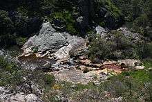
The river is known to have toxic algal blooms with the last occurring in 2007. Algal blooms usually occur after hot weather and in the upper reaches of the river.[2]
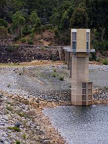 Serpentine Dam
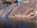 Serpentine Falls
References
- ↑ "Bonzle Digital Atlas - Map of Serpentine River, WA". 2006. Retrieved 23 November 2008.
- ↑ "ABCNews - Serpentine River algae may damage health WA". 2007. Retrieved 27 November 2008.
See also
Coordinates: 32°34′33″S 115°45′39″E / 32.57583°S 115.76083°E
Rivers of Western Australia | |
|---|---|
| Rivers of the Gascoyne region | |
| Rivers of the Goldfields-Esperance region | |
| Rivers of the Great Southern region | |
| Rivers of the Kimberley region |
|
| Rivers of the Mid West region | |
| Rivers of the Peel and Perth regions (and streams) | |
| Rivers of the Pilbara region | |
| Rivers of the South West region | |
| Rivers of the Wheatbelt region | |
| |