Margaret River (Kimberley, Western Australia)
| Margaret River | |
|---|---|
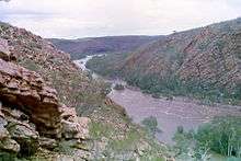 Margaret River in flood at the entrance to the King Leopold Ranges | |
| Country | Australia |
| Basin | |
| Main source |
King Leopold Range 498 metres (1,634 ft)[1] |
| River mouth |
Fitzroy River 110 metres (361 ft) |
| Physical characteristics | |
| Length | 335 kilometres (208 mi)[2] |
The Margaret River is a river in the Kimberley of Western Australia.
The river was named on 29 May 1879 by the explorer Alexander Forrest, during an expedition in the Kimberley area, after his sister-in-law Margaret Elvire Forrest, wife of his brother John Forrest, who was later to be Premier of Western Australia.[3]
The headwaters of the river rise in the King Leopold Range West of Halls Creek and flows in a westerly until it merges with the Fitzroy River of which it is a tributary. The junction of the two rivers is close to Fitzroy Crossing. The Margaret River has 15 tributaries including; Mary River, Gliddon River, O'Donnell River, Leopold River, Louisa River, Station Creek, Dead Horse Creek, Gidgia Creek and Boab Creek.
The state Public Works Department set up a flow monitoring station on the Margaret River at the entrance of the gorge where it enters the Mueller Ranges in 1966. Debate continues about the use of the Fitzroy River basin as a water source for the South West of Western Australia.
Fish such as the Barramundi, Freshwater Sawfish, Greenway's grunter and the False-spine Catfish have all been found within the river system.[4]
The traditional owners of the areas around the river are the Djaru, Kitja and Konejandi peoples.[5]
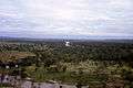 Margaret River near the Louisa Downs Homestead
References
- ↑ "Bonzle Digital Atlas – Map of Margaret River". 2009. Retrieved 10 July 2016.
- ↑ Western Australian Land Information Authority. "History of river names". Archived from the original on 16 February 2015. Retrieved 7 September 2011.
- ↑ Forrest, Alexander (8 Feb 1880). "From the De Grey to Port Darwin: Journal of Exploration". The West Australian. p. 1S. Retrieved 19 Aug 2013.
- ↑ "National River Trust – Inland fish fauna of the Fitzroy river" (PDF). 2002. Retrieved 17 September 2010.
- ↑ "AusAnthrop Australian Aboriginal tribal database". 2012. Retrieved 6 May 2012.
Coordinates: 18°10′24″S 125°37′5″E / 18.17333°S 125.61806°E
Rivers of Western Australia | |
|---|---|
| Rivers of the Gascoyne region | |
| Rivers of the Goldfields-Esperance region | |
| Rivers of the Great Southern region | |
| Rivers of the Kimberley region |
|
| Rivers of the Mid West region | |
| Rivers of the Peel and Perth regions (and streams) | |
| Rivers of the Pilbara region | |
| Rivers of the South West region | |
| Rivers of the Wheatbelt region | |
| |