Interstate 190 (Massachusetts)
Interstate 190 (I-190) runs for 19.26 miles (31.00 km) north from I-290 in Worcester to Route 2 in Leominster in the US state of Massachusetts. A portion of the highway was built with extra-wide shoulders, which are painted green, to prevent runoff from contaminating the nearby Wachusett Reservoir.[2] The green color is also intended to reduce the perceived width of the unusually wide road.
Route description
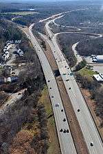
I-190 interchange with Route 2 in Leominster, MA
I-190 begins at a southern terminus with I-290 in Worcester. Near the Greendale Mall, there is an interchange with Route 12 before the highway passes along the eastern shore of Indian Lake and goes through the city of Worcester. In West Boylston, I-190 has another interchange with Route 12 before turning to the northwest into Holden and then the north and crossing the Quinapoxet River. The freeway curves to the northeast reentering West Boylston and enters a more rural area, and I-190 intersects Route 140 and Route 12 another time in Sterling. In Lancaster, I-190 has an exit for Route 117. North of Johnny Appleseed State Park and Lancaster State Forest, I-190 merges and terminates at Route 2 and Mechanic Street in the city of Leominster.[3]
Exit list
All interchanges will be renumbered to mileage-based numbers under a project scheduled to start in 2016.[4] The entire route is in Worcester County. [5]
References
- ↑ Staff (October 31, 2002). "Table 2: Auxiliary Routes of the Eisenhower National System of Interstate and Defense Highways". Route Log and Finder List. Federal Highway Administration.
- ↑ "Ask the Globe". The Boston Globe. June 21, 1997. Retrieved December 2, 2013. (subscription required (help)).
Massachusetts Highway spokeswoman Julie Vitek says those paved shoulders and similar ones in West Boylston near the Wachusett Reservoir were built in the 1970s to direct collected melted snow and salt into a Massachusetts highway closed well system, independent from drinking water supplies.
- ↑ Google (December 21, 2013). "I-190 Massachusetts" (Map). Google Maps. Google. Retrieved December 21, 2013.
- ↑ Commonwealth of Massachusetts (2015). "COMMBUYS - Bid Solicitation FAP# HSIP-002S(874) Exit Signage Conversion to Milepost-Based Numbering System along Various Interstates, Routes and the Lowell Connector". Retrieved January 5, 2016.
- 1 2 3 MassDOT Planning Division. "Massachusetts Route Log Application". Massachusetts Department of Transportation. Retrieved August 21, 2014.
- 1 2 "Exit Numbers and Names: Route I-190 (Worcester to Leominster)". Massachusetts Department of Transportation. Retrieved August 21, 2014.
External links
Route map: Bing / Google
Template:Attached KML/Interstate 190 (Massachusetts)
KML is from Wikidata

