Ine, Kyoto
| Ine 伊根町 | ||
|---|---|---|
| Town | ||
| ||
 Location of Ine in Kyoto Prefecture | ||
 Ine Location in Japan | ||
| Coordinates: 35°41′N 135°17′E / 35.683°N 135.283°ECoordinates: 35°41′N 135°17′E / 35.683°N 135.283°E | ||
| Country | Japan | |
| Region | Kansai | |
| Prefecture | Kyoto Prefecture | |
| District | Yosa | |
| Government | ||
| • Mayor | Yoshimoto Hideki | |
| Area | ||
| • Total | 61.98 km2 (23.93 sq mi) | |
| Population (2008) | ||
| • Total | 2,500 | |
| • Density | 40/km2 (100/sq mi) | |
| Symbols | ||
| • Tree | Japanese Black Pine | |
| • Flower | Chrysanthemum | |
| Time zone | Japan Standard Time (UTC+9) | |
| Website |
www | |

Ine (伊根町 Ine-chō) is a town located in Yosa District, Kyoto Prefecture, Japan. The Tango Peninsula was a trade route from Eurasian Continent to Kyoto.
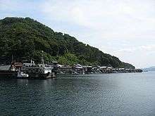
It is famous for wooden fishing houses called funaya, selected as Groups of Traditional Buildings. Tsutsukawa district and Honjo-Hama district have been handed down Urashima Tarō legend.
As of 2008, the town has an estimated population of 2,500. The total area is 61.98 km².
History
Ine was founded on November 3, 1954 by the merger of four villages.
Geography
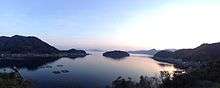
Located on the coast of the Sea of Japan on the northeast side of the Tango Peninsula in the northwestern corner of the prefecture.
Politics and government
Ine is governed by mayor Yoshimoto Hideki, an independent. The city assembly has 10 members.
Industry
Industrial population
- All of employed : 1,334
- The primary industry : 412
- The secondary industry : 213
- The tertiary industry : 707
Fishery
An total annual a catch is 3,190 tons, account for 25 percent of all a catch in Kyoto Prefecture.
Transportation
Bus
- Tankai Bus
- Ine Line
- Kamanyu Line
- Kyōgamisaki Line
- The municipal Bus
Ports
- The Ine sea route
Tourism
- Funaya of Ine
- The spa of Oku-Ine
- Urashima Park
- The Urashima shrine (Ura Shrine)
External links
![]() Media related to Ine, Kyoto at Wikimedia Commons
Media related to Ine, Kyoto at Wikimedia Commons
- Ine official website (Japanese)
| Wards of Kyoto | ||
|---|---|---|
| Cities | ||
| Funai District | ||
| Kuse District | ||
| Otokuni District | ||
| Sōraku District | ||
| Tsuzuki District | ||
| Yosa District | ||