Fukuchiyama, Kyoto
| Fukuchiyama 福知山市 | ||
|---|---|---|
| City | ||
| ||
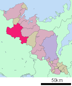 Location of Fukuchiyama in Kyōto Prefecture | ||
 Fukuchiyama Location in Japan | ||
| Coordinates: 35°18′N 135°8′E / 35.300°N 135.133°ECoordinates: 35°18′N 135°8′E / 35.300°N 135.133°E | ||
| Country | Japan | |
| Region | Kansai | |
| Prefecture | Kyōto Prefecture | |
| Government | ||
| • Mayor | Kazuo Ohashi | |
| Area | ||
| • Total | 552.54 km2 (213.34 sq mi) | |
| Population (October 1, 2015) | ||
| • Total | 78,935 | |
| • Density | 140/km2 (370/sq mi) | |
| Symbols | ||
| • Tree | ||
| • Flower |
| |
| • Bird | ||
| Time zone | Japan Standard Time (UTC+9) | |
| City hall address |
13-1 Naiki, Fukuchiyama-shi 620-8501 | |
| Website |
www | |

Fukuchiyama (福知山市 Fukuchiyama-shi) is a city in northern Kyoto Prefecture, Japan, on the Yura River. It is about 25 km inland from the Sea of Japan at the Fukuchiyama Valley's southern end, and is surrounded by mountains to the south, west, and east. The city was founded on April 1, 1937.
As of 2015, the city has an estimated population of 78,935 and a population density of 142.9 persons per km2. The total area is 552.54 km2.
On January 1, 2006, the towns of Miwa and Yakuno (both from Amata District), and the town of Ōe (from Kasa District) were merged into Fukuchiyama.

Transport
Inter-city trains stop at Fukuchiyama Station, with connections to Osaka, Kyoto, and Amanohashidate, among others.
See also
- Osamu Shimomura, a Nobel Prize–winning chemist, born in Fukuchiyama
- Kenta Kobashi, a professional wrestling icon, born in Fukuchiyama
- Sadakazu Tanigaki, Secretary-General of the LDP, born in Fukuchiyama
External links
![]() Media related to Fukuchiyama, Kyoto at Wikimedia Commons
Media related to Fukuchiyama, Kyoto at Wikimedia Commons
| Wards of Kyoto | ||
|---|---|---|
| Cities | ||
| Funai District | ||
| Kuse District | ||
| Otokuni District | ||
| Sōraku District | ||
| Tsuzuki District | ||
| Yosa District | ||