Indian, Anchorage
Indian (also known as Indian Valley) is a community in the Municipality of Anchorage, Alaska, United States. It lies in a valley in the Chugach Mountains near the middle of the north shore of the Turnagain Arm of Cook Inlet. It is about 24 miles (39 km) southeast of downtown Anchorage and about 3 miles (4.8 km) northwest of Bird, and about 13 miles (21 km) west-northwest of Girdwood.
Description
The community is located just west of Indian Creek and north of the Seward Highway within the Indian Valley. (The Seward Highway provides the only roadway access to Indian.)[1] Although not part of the Chugach State Park, the community is entirely surrounded by the park.[2]
Although the Alaska Railroad passes through the southern edge of the community (and has a siding that runs most of the length of community) none the railroad's regular passenger trains stop in Indian. However, there are two special event trains that operate out of the Anchorage station that turn around (reverse direction) in Indian before returning to Anchorage. These two trains include the annual Easter Train and the Holiday Train (which runs twice each day on selected Saturdays in December).[3][4] Neither train allows passengers to disembark in Indian.
The origin of the community (and currently one of the main attractions) is the Indian Valley Mine. The mine was established 1920 and is currently listed on the National Register of Historic Places.[5]
See also
References
- ↑ Google (10 Nov 2015). "Indian, Anchorage, AK" (Map). Google Maps. Google. Retrieved 10 Nov 2015.
- ↑ "Chugach State Park" (PDF) (Map). dnr.alaska.gov. 1:80,000. Cartography by Martin Stahl. Alaska Department of Natural Resources: Division of Parks & Outdoor Recreation. 12 Dec 2009. Retrieved 10 Nov 2015.
- ↑ "Easter Train". alaskarailroad.com. Alaska Railroad. Archived from the original on 30 Jun 2015. Retrieved 13 Nov 2015 – via archive.web.org.
- ↑ "Holiday Train". alaskarailroad.com. Alaska Railroad. Retrieved 13 Nov 2015.
- ↑ "Assest Detail: Indian Valley Mine". nps.gov. National Park Service. Retrieved 10 Nov 2015.
External links
- Indian Valley Mine (official website)
Municipalities and communities of City and Borough of Anchorage, Alaska, United States | ||
|---|---|---|
| City | 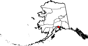 | |
| Outlying communities | ||
| Abandoned | ||
Coordinates: 60°59′N 149°31′W / 60.99°N 149.51°W