Chugach Mountains
| Chugach Mountains | |
|---|---|
 View of the Chugach Mountains from the Glenn Highway north of Anchorage | |
| Highest point | |
| Peak | Mount Marcus Baker |
| Elevation | 13,094 ft (3,991 m) |
| Coordinates | 61°26′14″N 147°45′10″W / 61.43722°N 147.75278°W |
| Dimensions | |
| Length | 300 mi (480 km) E-W |
| Geography | |
| Country | United States |
| State | Alaska |
| Range coordinates | 61°10′N 145°20′W / 61.17°N 145.33°WCoordinates: 61°10′N 145°20′W / 61.17°N 145.33°W |
| Parent range | Pacific Coast Ranges |

The Chugach Mountains of southern Alaska are the northernmost of the several mountain ranges that make up the Pacific Coast Ranges of the western edge of North America. The range is about 250 miles (402 km) long and 60 miles (97 km) wide, and extends from the Knik and Turnagain Arms of the Cook Inlet on the west to Bering Glacier, Tana Glacier, and the Tana River on the east. It is bounded on the north by the Matanuska, Copper, and Chitina rivers. The highest point of the Chugach Mountains is Mount Marcus Baker, at 13,094 feet (3,991 m), but with an average elevation of 4,006 feet (1,221 m), most of its summits are not especially high.[1] Even so its position along the Gulf of Alaska ensures more snowfall in the Chugach than anywhere else in the world; an annual average of over 1500 cm (600 in).[2]
The mountains are protected in the Chugach State Park and the Chugach National Forest. Near to Anchorage, they are a popular destination for outdoor activities. Weather permitting, the World Extreme Skiing Championship is held annually in the Chugach Mountains near Valdez.
The Richardson Highway, Seward Highway, Portage Glacier Highway, and the Glenn Highway run through the Chugach Mountains. The Anton Anderson Memorial Tunnel of the Portage Glacier Highway provides railroad and automobile access underneath Maynard Mountain between Portage Lake and the city of Whittier on Prince William Sound.
History
The name "Chugach" comes from Chugach Sugpiaq "Cuungaaciiq" (in the modern spelling) meaning "Cook Inlet"; Russians applied this name to the indigenous Sugpiaq or Alutiiq people of the southern Kenai Peninsula and Prince William Sound, usually describing place names as Chugachik and the people as Chugatz and Tshougatskoy. In 1898 United States Army Captain William R. Abercrombie spelled the name "Chugatch" and applied it to the mountains.[1] It is possible that the Koniagmiut (Sugpiat or Alutiit of the Kodiak Archipelago and the Alaska Peninsula) may also have called these northern Sugpiat "Cuungaaciirmiut" in ancient times but it is also possible that this was a neologism during Russian times.
Mountains
The twelve highest peaks in the Chugach Mountains are listed below:
Other important peaks in the Chugach Mountains include:
- Mount Michelson 8,156 feet (2,486 m)[15]
- Bashful Peak 8,005 feet (2,440 m)
- Mount Billy Mitchell 6,919 feet (2,109 m)[16]
- Mount Palmer 6,585 feet (2,007 m)[17]
- Eagle Peak 6,424 feet (1,958 m)[18]
- Polar Bear Peak 5,430 feet (1,655 m)[19]
- North Suicide Peak 5,065 feet (1,544 m)
- Ptarmigan Peak 4,409 feet (1,344 m)[20]
- Byron Peak 4,590 feet (1,399 m)
- Flattop Mountain 2,979 feet (908 m)[21]
- Bold Peak 7,522 feet (2,293 m)
Gallery
-

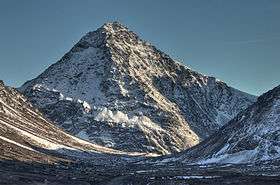
Bold Peak
-
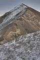
North Suicide Peak
-

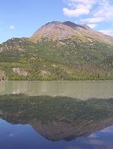
Peters Creek backcountry, below Mount Rumble
-
Mount Eklutna
-

Bashful Peak, the tallest mountain in western Chugach State Park
-

Small stream in the Chugach Mountains
-

Bold Peak
See also
References
- 1 2 "Chugach Mountains". Geographic Names Information System. United States Geological Survey. Retrieved 2012-07-25.
- ↑ Steep, Freeskiing Documentary, 2007
- ↑ "Mount Marcus Baker". Geographic Names Information System. United States Geological Survey. Retrieved 2012-07-25.
- ↑ "Mount Thor". Geographic Names Information System. United States Geological Survey. Retrieved 2012-07-25.
- ↑ "Mount Valhalla". Geographic Names Information System. United States Geological Survey. Retrieved 2012-07-25.
- ↑ "Mount Witherspoon". Geographic Names Information System. United States Geological Survey. Retrieved 2012-07-25.
- ↑ "Mount Einstein". Geographic Names Information System. United States Geological Survey. Retrieved 2012-07-25.
- ↑ "Mount Tom White". Geographic Names Information System. United States Geological Survey. Retrieved 2012-07-25.
- ↑ "Icing Peak". Chugach Mountains. peakbagger.com. 2012. Retrieved 2012-07-25.
- ↑ "Mount Grace". Chugach Mountains. peakbagger.com. 2012. Retrieved 2012-07-25.
- ↑ "Mount Goode". Geographic Names Information System. United States Geological Survey. Retrieved 2012-07-25.
- ↑ "Mount Steller". Geographic Names Information System. United States Geological Survey. Retrieved 2012-07-25.
- ↑ "Mount Gannett". Geographic Names Information System. United States Geological Survey. Retrieved 2014-06-19.
- ↑ "Mount Miller". Geographic Names Information System. United States Geological Survey. Retrieved 2012-07-25.
- ↑ "Mount Michelson". Geographic Names Information System. United States Geological Survey. Retrieved 2012-07-25.
- ↑ "Mount Billy Mitchell". Geographic Names Information System. United States Geological Survey. Retrieved 2012-07-25.
- ↑ "Mount Palmer". Geographic Names Information System. United States Geological Survey. Retrieved 2012-07-25.
- ↑ "Eagle Peak". Geographic Names Information System. United States Geological Survey. Retrieved 2012-07-25.
- ↑ "Polar Bear Peak". Geographic Names Information System. United States Geological Survey. Retrieved 2012-07-25.
- ↑ "Ptarmigan Peak". Geographic Names Information System. United States Geological Survey. Retrieved 2012-07-25.
- ↑ "Flattop Mountain". Geographic Names Information System. United States Geological Survey. Retrieved 2012-07-25.