Illinois–Indiana State Line Boundary Marker
| Illinois-Indiana State Line Boundary Marker | |
|---|---|
|
Illinois-Indiana State Line Boundary Marker | |
| Location | Chicago, Illinois/Hammond, Indiana, United States |
| Coordinates | 41°42′28″N 87°31′28″W / 41.707842°N 87.524471°WCoordinates: 41°42′28″N 87°31′28″W / 41.707842°N 87.524471°W |
| Built | 1838 |
| Designated | September 4, 2002 |
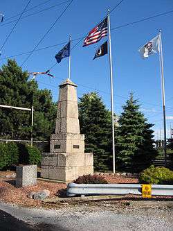
The Illinois–Indiana State Line Boundary Marker is a sandstone boundary marker obelisk located near the end of Chicago's Avenue G, just west of the State Line Generating Plant of Hammond, Indiana. Since 1988 it has been 159.359 miles (256.463 km) north of the Wabash River.
The obelisk was constructed by the Office of the United States Surveyor General ca. 1838. In 1988, the marker was relocated 191.09 feet (58.24 m) north of its original location, but the structure continues to straddle the state line between Illinois and Indiana. As one of the earliest structures still standing in Chicago, the marker earned Chicago Landmark status on September 4, 2002.[1]
References
- ↑ Illinois-Indiana State Line Boundary Marker, City of Chicago Department of Planning and Development, Landmarks Division (2003). Retrieved on 18 February 2010.
This article is issued from Wikipedia - version of the 10/9/2016. The text is available under the Creative Commons Attribution/Share Alike but additional terms may apply for the media files.