Ightenhill
| Ightenhill | |
.jpg) Countryside near Hunters Oak |
|
 Ightenhill |
|
| Population | 1,975 (2011) |
|---|---|
| OS grid reference | SD8208 |
| Civil parish | Ightenhill |
| District | Burnley |
| Shire county | Lancashire |
| Region | North West |
| Country | England |
| Sovereign state | United Kingdom |
| Post town | BURNLEY |
| Postcode district | BB12 |
| Dialling code | 01282 |
| Police | Lancashire |
| Fire | Lancashire |
| Ambulance | North West |
| EU Parliament | North West England |
| UK Parliament | Burnley |
|
|
Coordinates: 53°48′14″N 2°16′19″W / 53.804°N 2.272°W
Ightenhill is a civil parish in the Borough of Burnley in Lancashire, England, with a population of 1,975.[1] It is also considered to be a district of the town of Burnley, with boundaries that do not follow those of the parish.
The district is composed principally of a large 1990s housing estate. It is bounded to the north and east by the River Calder, to the south by the Leeds and Liverpool Canal and the M65 motorway, and to the west by Padiham Road. It is in the Whittlefield with Ightenhill ward of Burnley borough.
History
The name is historically recorded as Hightenhull (1238), Ightenhill (1242), Hucnhull (1258) and Ichtenhill (1296 and 1305) and is derived from a local hill.[2]
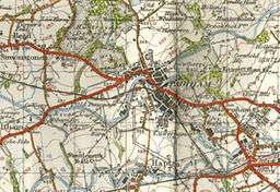
The site of Ightenhill Manor House (53°48′09″N 2°16′36″W / 53.8025°N 2.2766°W) is about a quarter of a mile to the east of Gawthorpe Hall in a meadow on the brow of a hill, from which there is a good view of the whole of Pendle Forest. No part of the walls is standing, but in 1894 the foundations of the keep could easily be traced. The location of the manor is on the 1948 Ordnance Survey map shown here.[2]
The ancient township of Ightenhill Park was named for the area’s former status as a deer park, connected to the Forest of Pendle. In 1866 the township became a civil parish.[3] The present parish was created in 1894, mainly from the former, but with the small part of Habergham Eaves lying north of A671 Padiham Road, added to it. In 1926 a small part of the south-west of the parish was transferred into Burnley, with a footpath next to Bullions Close farm, marking the new boundary.[4]
In 1974, with the creation of the Borough of Burnley, the former parish of North Town historically associated with Padiham, was dissolved and the part south of the A6068 Padiham Bypass, including Gawthorpe Hall was added to Ightenhill.
Demography
According to the United Kingdom Census 2011, the parish has a population of 1,975,[1] an increase from 1,512 in the 2001 census.[5] According to the 2001 Census the ward had 97.13% white ethnic group.[6] The index of multiple deprivation indicates that most of the ward is more affluent than the national average:[7] only 4.34% of children in the ward are eligible for free school meals.[8] There were 52.7 crimes per 1,000 inhabitants in the year to December 2007 (Lancashire average 89.4), a fall of 8.1% on the previous twelve months[8]
Media gallery
.jpg) Descending towards the River Calder on the Burnley Way
Descending towards the River Calder on the Burnley Way High Whittaker
 Gawthorpe Hall
.jpg) The Brontë Way also passes through the parish
The Brontë Way also passes through the parish Hagg Wood
See also
References
- 1 2 "Key Figures for 2011 Census: Key Statistics". Office for National Statistics. Retrieved 1 July 2015.
- 1 2 British History online, accessed 3 February 2011
- ↑ "Ightenhill Park Tn/CP through time". visionofbritain.org.uk. GB Historical GIS / University of Portsmouth. Retrieved 1 August 2015.
- ↑ "Ightenhill CP through time". visionofbritain.org.uk. GB Historical GIS / University of Portsmouth. Retrieved 1 August 2015.
- ↑ Office for National Statistics : Census 2001 : Parish Headcounts : Burnley Retrieved 4 February 2010
- ↑ Neighbourhood Statistics
- ↑ Lancashire County Council Accessed 2010
- 1 2 Statistics - Lancashire MADE Public
External links
- Map of Ightenhill current (2011) parish boundary at Lancashire County Council website
- Map of Ightenhill parish boundary circa 1850
- Friends of Ightenhill Park
- Ightenhill Parish Council
- Ightenhill Primary School
- St Mary Magdalene's RC Primary School
| Wikimedia Commons has media related to Ightenhill. |
Geography of the Borough of Burnley | |||||||||||
|---|---|---|---|---|---|---|---|---|---|---|---|
| Towns |  | ||||||||||
| Villages & suburbs | |||||||||||
| Parishes | |||||||||||
| Topography |
| ||||||||||