Padiham
| Padiham | |
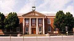 Padiham Town Hall in 1994, designed by Bradshaw Gass & Hope 1938 |
|
 Padiham |
|
| Population | 10,098 (2011) |
|---|---|
| OS grid reference | SD7933 |
| Civil parish | Padiham |
| District | Burnley |
| Shire county | Lancashire |
| Region | North West |
| Country | England |
| Sovereign state | United Kingdom |
| Post town | BURNLEY |
| Postcode district | BB12 |
| Dialling code | 01282 |
| Police | Lancashire |
| Fire | Lancashire |
| Ambulance | North West |
| EU Parliament | North West England |
| UK Parliament | Burnley |
|
|
Coordinates: 53°47′49″N 2°18′40″W / 53.797°N 2.311°W


Padiham /ˈpædiəm/ is a small town and civil parish on the River Calder, about 3 miles (5 km) west of Burnley and south of Pendle Hill, in Lancashire, England. It is part of the Borough of Burnley, but has its own town council with varied powers. Padiham was originally a rural village lying by the River Calder. It is still surrounded by attractive countryside on an arc running from the north-west to the north-east in the foothills of Pendle Hill.
According to the United Kingdom Census 2011, the parish has a population of 10,098,[1] an increase from 8,998 in the 2001 census.[2]
History
No prehistoric or Roman sites have been found in the urban area and Padiham, a name of Anglo-Saxon origin, is not recorded in the Domesday Book.[3] The first recorded mention of the town, as Padyngham, dates from 1294.[4] For hundreds of years it was a market town where produce from Pendleside was bought and sold. The town expanded and was substantially redeveloped during the Industrial Revolution and the central area is now a conservation area.
Padiham's population peaked around 1921 at about 14,000 declining to 10,000 in the early 1960s and 8,998 at the time of the 2001 census.[5][6] This follows people moving to the south of England in search of work following the decline of the traditional cotton, coal and engineering manufacturing base during that period.
The Queen, together with Prince Philip, first visited Burnley, Nelson and the old Mullard valve factory at Simonstone near Padiham on her post-Coronation tour of Lancashire in 1955.[7]
Governance
Padiham was once a township in the ancient parish of Whalley. This became a civil parish in 1866.[5] An urban district covered the town from 1894 (until 1974), however at this time the rural areas mainly to the north became a new civil parish called Northtown, forming part of the Burnley Rural District.[8] But the Padiham Green area, previously part of Hapton,[lower-alpha 1] transferred to Padiham with another small area following in 1935.[5] Since 1974 Padiham has formed part of the Borough of Burnley. A Town Council was established in 2002.[10]
Councillors for Padiham on Burnley Borough Council are elected to the Gawthorpe Ward, which covers most of Padiham but not Gawthorpe Hall,[11] with the southern and eastern areas covered by the Hapton with Park Ward.[12] Burnley Borough Council now addresses public correspondence to both the people of Burnley and Padiham. Padiham is part of Lancashire County Council and the Parliamentary Constituency is Burnley currently represented by Julie Cooper for the Labour Party.
Economy
In the 19th century, Padiham's industry was based on coal-mining and weaving. Helm Mill on Factory Lane was the first mill built in 1807. By 1906 there were twenty cotton mills[13] though the best preserved, now converted into flats, is Victoria Mill, built 1852–53 with an 1873 extension, in Ightenhall Street.[13] Industrial development was helped by the proximity of the Leeds and Liverpool Canal about 2 miles (3.2 km) south. By 1848, Padiham had many coal pits around the town, including two large collieries and a number of smaller workings. The availability of coal and water nearby helped the development of the cotton industry in the town.[3] The arrival of the railway at Hapton in 1840 and Padiham itself in 1877 further boosted industry in the town.[3] The last pit closed around 1870,[14] although mining continued in areas outside the town into the 1950s and open cast mining took place in the 1960s east of the town close to Gawthorpe Hall but north of the River Calder off Grove Lane.
Since the 1960s the remaining cotton mills have also continued a decline which began in the 1930s. Padiham's second role as a manufacturing base has also been in decline since the 1990s. The town's last major employer in this sector, Baxi, closed its factory in March 2007 with the loss of 500 jobs.[15] A modern business park, Shuttleworth Mead,[16] opened in 2001 on the western edge of the town on the site of the old Padiham Power Station[17] which closed in 1993, supported by £2.2 million from the European Regional Development Fund and £2 million from the North West Development Agency.[18] Tenants include Supanet, an internet service provider (ISP) and Graham & Brown, a wallcoverings company. In 2007 Fort Vale Engineering moved into the old Mullard/Philips site at Calder Vale Park, Simonstone which had closed in 2004, and developed a new purpose-built factory. Fort Vale Engineering employs around 280 people from around the local area and has brought new business to other local employers.
Landmarks
There are five significant halls in the local area: Huntroyde Hall,[19] dating from 1576, and Simonstone Hall, dating from 1660, in nearby Simonstone, are both privately owned. Gawthorpe Hall was donated to the National Trust in 1970 but is jointly managed with Lancashire County Council, which has a 99-year lease. Gawthorpe is in the Ightenhill district.[20] The Trust also runs an office and a tea room in the courtyard of the property.[21][22] Gawthorpe was the family home of the Shuttleworth family who occupied Shuttleworth Hall near Hapton from the 12th century.[23][24] The current building dates from 1639 and is still a working farm. Read Hall and Park is in the nearby village of Read, about 1 mile (1.6 km) west of Padiham on the A671.
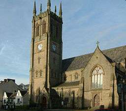
St Leonard's Church, the town's parish church, dates from 1866–69 and is a Grade II listed building.[25] It was built on the site of earlier churches dating back to at least 1451.[26] The original churchyard did not extend as far to the north as it does today. In 1802 proposals were made to extend the churchyard and remove "nuisances" on the north side of the church. In 1835 the churchyard was extended northwards and it seems likely that at this time the former premises of Padiham Grammar School were purchased and demolished.[3]
Sherry's Lancashire Cotton Mill is a working 19th-century cotton mill which is open to the public.[27]
Padiham Town Hall on Burnley Road, designed by Bradshaw Gass & Hope and built in 1938, is a Grade II listed building.[28]
Padiham Memorial Park at the top of Church Street, was designed by Thomas Mawson, an influential and prolific landscape designer.[29][30][31] It was officially opened in 1921 as a memorial to those from the town who gave their lives in the First World War, but it also records those who gave their lives in the Second World War.
The park covers 12 acres (4.9 ha) on two sites divided by the River Calder. The upper section is mainly formal, dominated by Knight Hill House, currently used as an Age UK (formerly Age Concern) day centre, and has a rose garden, lawns and two memorials. The lower section, off Park Street, has two bowling greens, tennis courts, skate park and Padiham Leisure Centre. The park is a Green Flag award winner.[32] The park still had the remains of some Second World War air raid shelters in 2008.[33]

Padiham War Memorial itself is at the main entrance to the park in Blackburn Road.[34] There is a second memorial at All Saints' with St John the Baptist off the A671, Padiham Road opposite the George IV pub.[35] A local man, Thomas Clayton, funded the park in his will; public subscription provided additional money for the park's many features.[36]
Near the war memorial, the Air Crash Memorial[37] is a memorial to several young people from the town killed on 3 July 1970 when a Dan Air de Havilland Comet deviated from its intended course and crashed into the high ground of the Montseny Range in north-eastern Spain. The aircraft, destroyed on impact and subsequent ground fire, contained three flight crew, four cabin crew and 105 passengers aboard, all of whom suffered fatal injuries. It was the airline's first fatal accident involving fare-paying passengers.[38] The tour operator, Clarkson's, was at the time the largest package holiday company in Britain.[39]
A number of other buildings in the area, less significant than Gawthorpe and others mentioned above, are still of historic interest. Hargrove can be seen from a public footpath off the Padiham by-pass and is just north of the town and the 1950s council housing estate north of Windermere Road. For over 400 years the house was the home of the Webster family of yeoman farmers.[40] The house is probably 17th-century and is part of the Huntroyed estate. Coal from a local outcrop heated the house for many years. Stockbridge House in Victoria Road was occupied by the Holts, a farming family, in 1802 and has a Jacobean chimney.[40] High Whitaker Farm is north-east of Hargrove, also accessible by public footpath from both Higham Road and Grove Lane. The building is 16th- century and said to have been used to hide Catholics during the reign of Henry VIII.[40] Other houses of note are Priddy Bank Farm and Foulds House Farm, both off Sabden Road, and Arbory Lodge on Arbory Drive.[40]
Transport
Rail
Padiham railway station was on a branch line (usually known as the Great Harwood loop) of the East Lancashire Line from Burnley to Blackburn which opened in 1877; it was closed on 2 December 1957 and the railway station later demolished. The railway line was retained for continuing deliveries of coal to Padiham Power Station until the power station closed in 1993. The nearest railway station is now at Hapton, about 2 miles (3.2 km) south and the line converted to a footpath/bridleway/cycleway called the Padiham Greenway, completed in June 2010. The town is now served by Transdev in Burnley & Pendle bus services from Accrington, Burnley, Nelson, Colne and beyond,[41] and Blackburn Bus Company service 152 from Burnley, Blackburn and Preston.[42]
Road
Junctions 8 and 10 of the M65, both around 2 miles (3 km) from the town centre, give Padiham access to the motorway network. Junction 8 of the M65 also gives the town access to the A56 dual carriageway leading to the M66 and quick access to the Manchester motorway network.
The nearest airport, Manchester, is 50 minutes' driving time from the town.[43] The most convenient route by public transport – via Blackburn, then by train – takes approx. 2¼ hours.[44]
Flooding
In December 2015, central Padiham was severely damaged by flooding when the River Calder burst its banks and engulfed neighbouring homes and businesses. Restoration work continues.
Historic maps
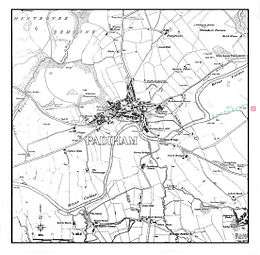
The 1845[3][45] map (1) shows the town of Padiham in the early days of the Lancashire cotton industry in Victorian times with three mills already marked. Most of the town at this stage was north of the river. Part of the Huntroyde Demesne[19] is marked in the top left corner. The River Calder, on the right of the map, flows to the north, having been diverted from its original route, away from Gawthorpe Hall (indicated in pink), in the early 19th century, because of pollution. In the 1960s the river was re-routed to its original course to accommodate open cast coal mining.[26] The 1890 Ordnance Survey map (2) shows the growth of the cotton industry in the latter part of the 19th century. The 1–25,000 scale OS map (3) is a partial extract from the two maps indicated. A number of historical locations are shown including Read Hall (A2) and Read (B2); Martholme, just east of the start of the Martholme Viaduct (A3); Simonstone and Simonstone Hall (C3); Huntroyd and grounds (D1-D2); Padiham Power Station (D3) with the connecting branch line for fuel; post-war housing development north of the town off Slade Lane (E2); High Whitaker (F1); River Calder on the old alignment from Gawthore Hall and grounds (F2); Location of Pendle Hall (G1); Location of Ightenhill Manor House (G2); Leeds and Liverpool Canal in Burnley (J1). The line of the railway line through Padiham is also shown.
- −
 1: Map of Padiham c. 1844
- −
 2: Ordnance Survey map dated 1890
- −
 3: Extract from OS 1-25,000 scale maps SD73 (west section pub 1955) and SD83 (east section published 1954) showing historical locations around Padiham. Grid lines are 1 km.
- −
People
- William Blezard, composer who worked with Joyce Grenfell and others, born in Padiham
- Thomas Birtwistle, trade unionist, involved in the weavers' strikes at Padiham in 1859
- Richard Bradshaw, Blackpool F.C. footballer, born in Padiham
- Maurice Green (1906–1987), editor of The Financial Times and The Daily Telegraph born in Padiham
- Cyril Harrison (1901–1980), managing director of English Sewing Cotton Company, educated at Padiham Weslyan School
- Gerardine Hemingway MBE, fashion designer, wife and business partner of Wayne Hemingway[46]
- Harry Hill, cyclist, bronze medal winner in the 1936 Olympic Games in Berlin, born in Padiham.[47] Too poor to get to London any other way, Hill cycled the 200 miles from Sheffield using the bike he used during the Olympic Games[48]
- Sir James Kay-Shuttleworth, 1st Baronet (1804–1877), husband of Janet Kay-Shuttleworth of Gawthorpe Hall. He founded teacher training and independent school inspection in England and what has become the University of St Mark & St John known as "Marjon"
- Ughtred James Kay-Shuttleworth (1844–1939), 1st Baron Shuttleworth, Liberal politician, son of Sir James Kay-Shuttleworth and his wife, Janet. Under-Secretary of State for India and Chancellor of the Duchy of Lancaster under William Gladstone in 1886 and Parliamentary and Financial Secretary to the Admiralty under Gladstone and Lord Rosebery between 1892 and 1895. He inherited Gawthorpe on the death of his mother in 1872
- Charles Geoffrey Nicholas Kay-Shuttleworth, 5th Baron Shuttleworth (born 1948), Lord Lieutenant of Lancashire 1997
- Le Gendre Starkie (1799–1865) and Le Gendre Starkie, landowners at Huntroyde
- John Pierce Chamberlain Starkie (1830–1888), landowner at Ashton Hall, in Thurnham, Lancashire
- Alfred Edward Tysoe, athlete and winner of two gold medals in the 800m and 5,000m team races in the 1900 Olympic Games, born in Padiham[49]
See also
- Listed buildings in Padiham
- History of Lancashire
- The Brontë Way
- Lancashire Cotton Corporation: set up to rescue the cotton industry from 1929
- Lancashire Cotton Famine: the impact of the American Civil War on the cotton industry in north-west England by problems with US cotton imports
- List of mills in Padiham
- Burnley Corporation Tramways
- List of schools in the Borough of Burnley
- Leck Hall: current seat of Baron Shuttleworth, of Gawthorpe Hall
- Padiham F.C. The town's football club founded 1878
- Padiham Heritage Appraisal 2015
References
Notes
- ↑ The old township boundary with Hapton followed the River Calder and its tributary Green Brook.[9]
Citations
- ↑ "Key Figures for 2011 Census: Key Statistics". Office for National Statistics. Retrieved 1 July 2015.
- ↑ Office for National Statistics : Census 2001 : Parish Headcounts : Burnley Retrieved 4 February 2010
- 1 2 3 4 5 Historic Town Assessment Report, Padiham, Lancashire County Council, May 2005, includes several old maps of the town and location of buildings – accessed 18 August 2011
- ↑ About Padiham Accessed 4 February 2010
- 1 2 3 "Padiham Ch/CP through time". visionofbritain.org.uk. GB Historical GIS / University of Portsmouth. Retrieved 18 October 2013.
- ↑ 2001 census data. Accessed 8 December 2007
- ↑ British Pathé Newsreel 1995 Accessed 2014_02_01
- ↑ "Northtown CP through time". visionofbritain.org.uk. GB Historical GIS / University of Portsmouth. Retrieved 18 October 2013.
- ↑ Lancashire and Furness (Map) (1st ed.). 1 : 10,560. County Series. Ordnance Survey. 1848.
- ↑ "Padiham Town Council – About us". Padiham Town Council. Retrieved 13 October 2013.
- ↑ "Gawthorpe". Ordnance Survey Linked Data Platform. Ordnance Survey. Retrieved 6 January 2016.
- ↑ "Hapton with Park". Ordnance Survey Linked Data Platform. Ordnance Survey. Retrieved 6 January 2016.
- 1 2 Pevsner, Nikolaus; Hartwell, Clare (revision) (2009). The Buildings of England – Lancashire: North. London and New Haven: Yale University Press. pp. 490–496. ISBN 978-0-300-12667-9.
- ↑ Padiham Life
- ↑ 'Job Threat After Factory Closure' , BBC News website 15 March 2007, accessed 14 January 2008
- ↑ Shuttleworth Mead Business Park. Accessed 5 September 2008
- ↑ Lancashire County Council proposals for public footpath July 2009, Accessed 11 February 2010
- ↑ North West Regional Development Agency. Accessed 6 September 2008
- 1 2 Parks and Gardens UK – based on the English Heritage Register of Parks and Gardens of Special Historic Interest
- ↑ National Trust Website, accessed 2 October 2008
- ↑ Searchable guide to country houses, includes Gawthorpe and other houses owned by the Shuttleworths – accessed 18 April 2010
- ↑ www.genuki.org.uk Accessed 13 November 2007
- ↑ Grimshaw and Shuttleworth family origin website, accessed 15 January 2011
- ↑ Pevsner, Nikolaus; Hartwell, Clare (revision) (2009). The Buildings of England – Lancashire: North. London and New Haven: Yale University Press. p. 321. ISBN 978-0-300-12667-9.
- ↑ Lancashire Family History & Heraldry Society. Accessed 13 November 2007
- 1 2 Armstrong, Duncan (1985). "Owd Padiham" – a pictorial history. Padiham: Mercer Print.
- ↑ Mill shops in Burnley and Padiham 2010 Accessed 21 October 2010
- ↑ Lancashire County Council Library and Information Service Accessed 25 February 2008
- ↑ Burnley Borough Council report on restoration of Padiham Memorial Park. Accessed 28 July 2009
- ↑ Parks and Gardens register UK – the park had not been surveyed at the data accessed −3 February 2010
- ↑ Lancashire Gardens Trust, accessed 17 April 2010
- ↑ Green Flag Award Scheme Accessed 27 February 2008
- ↑ "World War II Air Raid shelters in Memorial Park". Retrieved 19 January 2009.
- ↑ "World War I Cemeteries, Padiham War memorial (includes WWII)". Retrieved 19 January 2009.
- ↑ "World War memorial at All Saints with St John the Baptist, BB12 6PA (includes WWII)". Retrieved 19 January 2009.
- ↑ Burnley Borough Council. Accessed 28 February 2008.
- ↑ "Air Crash Memorial, Padiham Memorial Park looking west in the direction of Blackburn". Retrieved 19 January 2009.
- ↑ "Dan Air, air crash, northern Spain, Friday, 3 July 1970". Retrieved 19 January 2009.
- ↑ "BBC on this day, Friday, 3 July 1970". BBC News. 3 July 1970. Retrieved 19 January 2009.
- 1 2 3 4 Nadin, Jack; Armstrong, Duncan (2009). "Padiham in Old Photographs" – contains additional histories of properties mentioned. The History Press. pp. 10–16. ISBN 978-0-7524-5188-6.
- ↑ Mainline bus services
- ↑ Lancashire United Bus Service
- ↑ www.theaa.com The AA route planning. Accessed 8 February 2010
- ↑ Journey planner direct website
- ↑ Detailed version of map at the Lancashire County Council website
- ↑ "Hemingway Design – Meet the team". Hemingway Design. Retrieved 1 April 2015.
- ↑ Sports Reference, accessed 28 September 2010
- ↑ "Goodbye to a true cycling superstar". Radcliffe. Bury Times. 5 February 2009.
- ↑ Sports Reference website, accessed 28 September 2010
External links
| Wikimedia Commons has media related to Padiham. |
- Burnley Borough Council
- Church of England Parish of Padiham and Hapton
- Padiham Town Council
- Visit Padiham
- Padiham Urban District Council archive catalogue
- Map sources for Padiham
Geography of the Borough of Burnley | |||||||||||
|---|---|---|---|---|---|---|---|---|---|---|---|
| Towns |  | ||||||||||
| Villages & suburbs | |||||||||||
| Parishes | |||||||||||
| Topography |
| ||||||||||