River Calder, Lancashire
| River Calder | |
|---|---|
|
The River Calder at Altham | |
| Country | England |
| Basin | |
| Main source | Calderhead, Cliviger, Lancashire |
| River mouth | River Ribble near Brockhall Village |
| Physical characteristics | |
| Length | 15 miles (24 km) |

The River Calder is a major tributary of the River Ribble, starting in Cliviger close to Burnley in Lancashire, England and is around 15 miles / 24 km in length. Its source is very close to that of the West Yorkshire river with the same name, and that of the River Irwell. It flows through Towneley Park passing Unity College and Fulledge Recreation Ground. It passes through a culvert in the Burnley Embankment on the Leeds and Liverpool Canal and on through Burnley town centre where it is joined by the River Brun at Active Way. It then flows north through the site of Burnley College and out of the town, where it is joined by Pendle Water before turning west past Ightenhill and Gawthorpe Hall and through the town of Padiham. It flows through Altham and Whalley, passing the ruins of Whalley Abbey, then being crossed by the red brick Whalley Viaduct. It meets the Ribble near Great Mitton.[1]
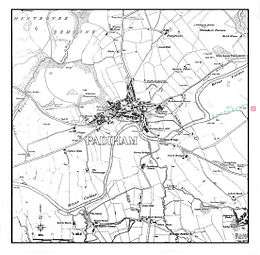
In its passage east of Padiham the river was diverted in the 19th century away from Gawthorpe Hall because of pollution, being restored to the original route in the 1960s.
Settlements

Tributaries
- Bushburn Brook
- Dean Brook
- Egg Syke Brook
- Rodger Hey Brook
- Sabden Brook
- Clough Syke Brook
- Hyndburn Brook
- Syke Side Brook
- Simonstone Brook
- Shorten Brook
- Dean Brook
- Castle Clough Brook
- Green Brook
- Whitaker Clough
- Moor Isles Clough
- Spurn Clough
- Pendle Water
- Barden Clough
- River Brun
- Everage Clough
- Dick Clough
- Easden Clough
- Black Clough
- Green Clough
References
- Rivers info accessed 14 December 2007.
External links
| Wikimedia Commons has media related to River Calder, Lancashire. |
| Rivers | |
|---|---|
| Canals | |
| Others | |
Geography of the Borough of Burnley | |||||||||||
|---|---|---|---|---|---|---|---|---|---|---|---|
| Towns |  | ||||||||||
| Villages & suburbs | |||||||||||
| Parishes | |||||||||||
| Topography |
| ||||||||||