Hurricane Bertha (2008)
| Category 3 major hurricane (SSHWS/NWS) | |
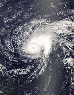 Hurricane Bertha near its peak intensity on July 7 | |
| Formed | July 3, 2008 |
|---|---|
| Dissipated | July 21, 2008 |
| (Extratropical after July 20, 2008) | |
| Highest winds |
1-minute sustained: 125 mph (205 km/h) |
| Lowest pressure | 952 mbar (hPa); 28.11 inHg |
| Fatalities | 3 direct |
| Damage | Minimal |
| Areas affected | Leeward Islands, East Coast of the United States, Bermuda, Atlantic Canada, Europe |
| Part of the 2008 Atlantic hurricane season | |
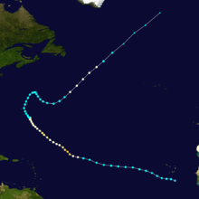
Hurricane Bertha was both the longest-lived and easternmost developing July tropical cyclone on record. The second named storm, as well as the first hurricane and major hurricane of the 2008 hurricane season, Bertha originated as a tropical wave over western Africa on July 1. After emerging into the eastern Atlantic, favorable environmental conditions allowed the wave to organize into a tropical depression two days later. Early on July 3, the depression intensified into a tropical storm, and by July 7, the system had acquired enough organization to be considered a Category 1 hurricane. Turning towards the northwest, a period of rapid deepening ensued thereafter. Bertha intensified into a major hurricane—a Category 3 or higher on the Saffir–Simpson hurricane wind scale—at 1800 UTC and further intensified to reach its peak intensity with winds of 125 mph (205 km/h) three hours later. A period of substantial weakening began early on July 8 as the system entered a region of higher wind shear, though it attained a secondary peak as a Category 2 hurricane on July 10. Shortly thereafter, the system entered an eyewall replacement cycle while simultaneously tracking over cooler ocean waters; this caused Bertha to weaken to a tropical storm by July 13. Moving northeast, southeast, and eventually resuming its northeast motion, the system attained hurricane intensity once again very briefly before transitioning into an extratropical cyclone on July 20. The extratropical low was absorbed by a larger system the following day.
Following formation, Bertha produced light precipitation across Cape Verde. Several days later, preceding its track across a large portion of the Atlantic, the system brought several inches of rain to Bermuda. Tropical storm-force winds caused minimal damage in the form of broken tree limbs and downed power outages; however, no fatalities were reported. Large swells impacted the East Coast of the United States as the hurricane curved out to sea, resulting in two fatalities; in addition, one swimmer was never found and is presumed dead. Strong rip currents along the coastline of North Carolina injured four while at least sixty required rescuing; farther north, in New Jersey, at least 57 people had to be rescued. In Delaware, at least 55 people were injured.
Meteorological history
Hurricane Bertha was first identified as a broad area of low pressure accompanying a tropical wave over western Africa in late June 2008. Tracking generally west-northwestward, the system emerged into the eastern Atlantic Ocean on July 1. Steady development took place as convection – thunderstorm activity – consolidated around its center, and spiral banding became better established. At 0300 UTC on July 3, the wave and associated low-pressure area was deemed sufficiently organized to be designated as Tropical Depression Two while centered roughly 220 mi (350 km) south-southeast of the Cape Verde Islands.[1] At this time, the National Hurricane Center (NHC) noted that the depression displayed intense convection near the center and increasingly pronounced banding features in the northwestern portion of the circulation. Additionally, the organization mentioned that the global models performed well in predicting the tropical cyclogenesis of Bertha, with the Global Forecast System (GFS) forecasting development of Bertha a week out.[2] Six hours later, the depression attained gale-force winds, and was subsequently upgraded to Tropical Storm Bertha after satellite estimates from both the Satellite Analysis Branch (SAB) and Tropical Analysis and Forecast Brach (TAFB) supported an intensity of 40 mph (55 km/h).[1][3]

Moving west-northwestward around the southern periphery of a mid-level ridge situated over the central Atlantic,[4] Bertha briefly stopped intensifying as cloud tops associated with the system warmed; despite this, banding features remained well-defined. However, the intensification process began shortly thereafter as a burst of deep convection developed atop the cyclone's center. The system was located within an environment conducive for strengthening, although it was noted in the 5:00 p.m. AST (2100 UTC) forecast discussion that Bertha would soon be entering an area of cooler sea surface temperatures.[5] Continuing towards the west-northwest, the tropical storm remained consistent in its intensity through the overnight hours of July 4, characterized at the time with a new burst of convection developing atop Bertha's center. Early the following day, satellite imagery revealed a ragged appearance in association with Bertha as it passed over sea surface temperatures near 77 °F (25 °C), values below the threshold needed to sustain a tropical cyclone. However, over the following hours, satellite imagery revealed a slightly better organized Bertha as the system entered an area of warmer sea surface temperatures.
During the afternoon hours of July 6, a series of microwave imagery depicted Bertha's low-level circulation tilted to the southwest of its mid-level center. Additionally, an eye-like feature became apparent, an indication that Bertha was gathering strength. A deep ring of convection surrounded this eye feature, and upper-level outflow spread towards the west. The system continued to intensify over the following hours, and given Bertha's microwave imagery appearance on July 7, the NHC upgraded the system to Category 1 hurricane status on the Saffir–Simpson Hurricane Wind Scale, the first of the season. At this time, the NHC predicted a peak intensity just below Category 2 hurricane status as an approaching trough produces high vertical wind shear began to impede on the system's development after 48 hours. Despite this, Bertha continued to intensify, and began a period of rapid intensification during the afternoon hours of July 7. During this time, Bertha intensified 50 mph (85 km/h) in a 15-hour period. At 5:00 p.m. AST (2100 UTC), Bertha reached its peak intensity as a strong Category 3 hurricane with winds of 125 mph (205 km/h) and a minimum barometric pressure of 952 mbar (hPa; 28.11 inHg).
After reaching peak intensity, satellite imagery revealed a rapid degradation in Bertha's structure. The well-defined eye previously observed had become cloud-filled and ragged, and microwave imagery evidenced that the western portion of the eyewall had eroded. This rapid weakening was likely due to the hurricane encountering an area of higher wind shear, cooler sea surface temperatures, and dry air entrainment. The advisory issued at 1100 a.m. AST (1500 UTC) dropped Bertha's maximum sustained winds to 100 mph (155 km/h), although it was noted that this could be conservative. Further weakening occurred over the next 24 hours as Bertha encountered unfavorable conditions for strengthening. However, after a decrease in wind shear, Bertha intensified to attain Category 2 hurricane status on July 10. While performing a gradual northward turn, Bertha fluctuated in intensity for several days while maintaining hurricane intensity.
By July 13, Bertha had weakened to a tropical storm while located a few hundred miles to the southeast of Bermuda. Turning northward before dipping southeastward, Bertha remained a tropical storm until July 18, at which time it was upgraded to a hurricane once again. It remained at this intensity until unfavorable conditions led to subsequent weakening on July 20. Bertha weakened to a tropical storm and transitioned into an extratropical cyclone shortly after. Its extratropical remnants persisted for the following 24 hours as they moved northeastward into the northern Atlantic, about midday between the island of Newfoundland and the Azores.
Preparations, impact, and records

As a tropical storm, Bertha dropped rainfall over the southern Cape Verde islands. No damages or deaths were reported.[6]
On July 7, Bermuda residents began purchasing lamps, tarpaulins and flashlights in anticipation of Hurricane Bertha. In the sudden rush, some stores sold out of batteries.[7] Bermuda Public Safety Minister Senator David Burch called a meeting of the island's Emergency Measures Organisation for the night of July 9. He also urged residents to prepare "emergency supply kits" of flashlights and batteries, a first aid kit, nonperishable foods, water and disposable utensils.[8] On July 10 the Department of Parks placed high surf warning signs along the South Shore beaches as Bertha sent strong waves ahead of its path.[9] On July 11 at 11 am AST the Bermuda Weather Service issued a tropical storm watch for the island,[10] and 24 hours later this was raised to a tropical storm warning.[11] On July 13, barricades were erected at all of the island's beaches, which were closed to swimming and watersports.[12]
All flights into and out of Bermuda were disrupted on July 14 as the storm made its final approach to the island. JetBlue and Delta Air Lines canceled their flights while American Airlines executed its flights to Miami and New York a day early, escaping before the tropical storm arrived. British Airways delayed its flight to the afternoon, hoping that the storm would have passed by the time its plane arrives.[12][13] Ferry service to St. Georges was canceled for the whole day,[12] and all other routes outside of Hamilton Harbour were canceled after their morning runs.[14] Some roads flooded, and tree branches were broken around the island. The wind downed power lines, causing scattered power outages, but engineers from the Bermuda Electric Light Company were reattaching cables immediately, even during the height of the storm.[14] Even as Bertha was passing to the east of the island and delivering tropical storm force winds, worries that it might re-strengthen to a hurricane before clearing the island prompted the government of Bermuda to issue a hurricane watch.[15] A total of 4.77 inches (121 mm) of rainfall fell at their international airport.[16]
The hurricane produced strong waves and rip currents along the East Coast of the United States, which caused three deaths along the coastline of New Jersey. On July 12, a 51-year-old man died after suddenly losing consciousness during his rescue. On July 13, three men swam out to a buoy about 300 ft (91.4 m) off the coast of Wildwood Beach when they were overcome by the rough surf. One swimmer was found unconscious in the water and pronounced dead at the scene, the second was never found and presumed dead, and the third was rescued. During the event, a total of 57 people had to be rescued along the coast of New Jersey.[17] Three rip currents also caused 55 injuries throughout beaches in Delaware. The injuries ranged from minor scrapes to broken bones.[18] Four people were also injured in North Carolina, one of which nearly drowned as he had aspirated water shortly before a lifeguard rescued him. At least 60 people had to be rescued from the rough seas over a two-day span.[19]
Hurricane Bertha holds the records for the longest-lived July Atlantic tropical cyclone at 17 days,[20] and the easternmost forming tropical storm, at 24.7°W.[21] The system is also the sixth strongest pre-August Atlantic tropical cyclone on record and was the third strongest July storm on record, behind Dennis and Emily of 2005.[22] Additionally, Bertha was the longest-lived tropical cyclone in the Atlantic Basin since Ivan in 2004. The system produced 4.77 inches (121 mm) of rainfall on the island of Bermuda, making it the 10th wettest storm in recorded history at that location.[16]
See also
- List of Atlantic hurricanes
- List of wettest tropical cyclones by country
- Timeline of the 2008 Atlantic hurricane season
- Hurricane Bill (2009)
References
- 1 2 Jamie R. Rhome (October 15, 2008). Tropical Cyclone Report: Hurricane Bertha (PDF). National Hurricane Center (Report). National Oceanic and Atmospheric Administration. Retrieved January 2, 2012.
- ↑ Eric S. Blake (July 3, 2008). "Tropical Depression Two Discussion Number 1". National Hurricane Center. Retrieved January 2, 2012.
- ↑ Daniel P. Brown (July 3, 2008). "Tropical Storm Bertha Discussion Number 2". National Hurricane Center. Retrieved January 2, 2012.
- ↑ Daniel P. Brown (July 3, 2008). "Tropical Storm Bertha Discussion Number 3". National Hurricane Center. Retrieved January 2, 2012.
- ↑ Daniel P. Brown (July 4, 2008). "Tropical Storm Bertha Discussion Number 7". National Hurricane Center. Retrieved January 2, 2012.
- ↑ Rhome (2008). "Tropical Storm Bertha Public Advisory #4". National Hurricane Center. Retrieved 2008-07-21.
- ↑ Staff Writer (2008-07-09). "No Title". Bermuda Sun: A1.
- ↑ Tim Smith (2008-07-09). "EMO meets today to discuss Hurricane Bertha". The Royal Gazette. Retrieved 2008-07-09.
- ↑ Staff Writer (2008-07-11). "Bertha back to Category One". The Royal Gazette. Retrieved 2007-07-11.
- ↑ Avila, Lixion. "Hurricane Bertha Forecast/Advisory Number 34". National Hurricane Center. Retrieved January 2, 2012.
- ↑ Avila, Lixion. "Hurricane Bertha Forecast/Advisory Number 38". National Hurricane Center. Retrieved January 2, 2012.
- 1 2 3 Amanda Dale (2008-07-14). "Bertha loses strength". The Royal Gazette. Retrieved 2008-07-14.
- ↑ Don Burgess (2008-08-14). "Flights cancelled as storm buffets Bermuda". The Bermuda Sun. Retrieved 2008-08-14.
- 1 2 Tim Hall (2008-07-14). "Causeway expected to remain open; buses to keep running". Bermuda Sun. Retrieved 2008-07-14.
- ↑ Tropical Storm BERTHA
- 1 2 Roth, David M. (April 29, 2015). "Tropical Cyclone Point Maxima". Tropical Cyclone Rainfall Data. United States Weather Prediction Center. Retrieved May 8, 2016.
- ↑ "NCDC Event Report: New Jersey Rip Currents". National Climatic Data Center. 2008. Retrieved 2009-01-28.
- ↑ "NCDC Event Report: Delaware Rip Currents". National Climatic Data Center. 2008. Retrieved 2009-01-28.
- ↑ "NCDC Event Report: North Carolina Rip Currents". National Climatic Data Center. 2008. Retrieved 2009-01-28.
- ↑ Shapley, Dan (July 18, 2008). "Bertha Is Longest-Lived Tropical Storm in History". thedailygreen. Retrieved January 2, 2012.
- ↑ Jeff Masters (2008). "Tropical Storm Bertha forms—and sets a record". Wunderground. Retrieved January 2, 2012.
- ↑ Jeff Masters (2008). "Hurricane Bertha: 6th strongest early season hurricane on record". Wunderground. Retrieved 2008-07-08.
External links
| Wikimedia Commons has media related to Hurricane Bertha (2008). |
- The National Hurricane Center's Advisory Archive for Hurricane Bertha
- Radar loop from Bermuda
- CIMSS Satellite Blog: Tropical Storm Bertha
Tropical cyclones of the 2008 Atlantic hurricane season | ||
|---|---|---|
 | ||
| ||