Tropical Storm Josephine (2008)
| Tropical Storm (SSHWS/NWS) | |
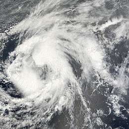 Tropical Storm Josephine near peak intensity on September 3 | |
| Formed | September 2, 2008 |
|---|---|
| Dissipated | September 14, 2008 |
| (Remnant low after September 6) | |
| Highest winds |
1-minute sustained: 65 mph (100 km/h) |
| Lowest pressure | 994 mbar (hPa); 29.35 inHg |
| Fatalities | None |
| Damage | Minimal |
| Areas affected | Cape Verde, and St. Croix |
| Part of the 2008 Atlantic hurricane season | |
Tropical Storm Josephine was the tenth tropical storm of the 2008 Atlantic hurricane season. Josephine developed out of a strong tropical wave which moved off the African coast on August 31. The wave quickly became organized and was declared Tropical Depression Ten while located 170 mi (270 km) to the south-southeast of the Cape Verde Islands on September 2. The depression was quickly upgraded to Tropical Storm Josephine around noon the same day. Over the next several days, Josephine moved in a general west-northwest direction and reached its peak intensity early on September 3. Strong wind shear, some due to the outflow of Hurricane Ike, and dry air caused the storm to weaken. On September 6, the combination of wind shear, dry air, and cooling waters caused Josephine to weaken into a tropical depression. Josephine deteriorated into a remnant low shortly after as convection continued to dissipate around the storm. The low ultimately dissipated while located 520 mi (835 km) east of Guadeloupe on September 10. However, the remnant moisture led to minor flooding on the island of St. Croix.
Meteorological history
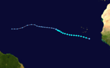
Tropical Storm Josephine formed as a tropical wave that emerged off the west coast of Africa near the end of August 2008. It tracked south of Cape Verde and slowly developed, and on September 2 the disturbance became Tropical Depression Ten while located south-southeast of the Cape Verde islands.[1] As the depression became more organized, an eye-like feature developed in the upper levels of the system. The depression was upgraded to Tropical Storm Josephine six hours after forming. Josephine was located in an area which was supportive for rapid intensification but was not forecast to intensify quickly.[2]
Josephine continued to intensify throughout the afternoon as the storm became more symmetrical. However, due to the location of the storm, there was a lack of accurate wind speed readings, and the National Hurricane Center was uncertain of its actual intensity.[3] Despite the lack of wind shear around the storm, the center became slightly exposed and ceased further intensification. The storm was also heading into an area where shear was forecasted to significantly increase due to an upper-level trough diving southward.[4] Despite convection being partially removed from the center of Josephine, the storm intensified slightly in the early morning hours on September 3 as thunderstorm activity to the south of the center became more organized. The intensification was forecast to be short in duration as the trough to the north was deepening, causing the wind shear to the west to become stronger.[5]
Josephine reached its peak intensity of 65 mph (100 km/h) around 8 a.m. (EDT) as it continued to become more organized. However, there were indications that it had already begun to weaken. Outflow towards the north was becoming restricted and arc clouds began emanating from the storm, a sign that dry air was entering the system.[6] During the afternoon hours, the structure of Josephine began to rapidly deteriorate as strong wind shear and dry air took their toll.[7] By the late night, the center was almost completely exposed and only a band of convection persisted near the center.[8]
Despite continuing effects from the strong wind shear, a large, deep burst of convection formed in the northern semicircle of Josephine. The center was found to have shifted towards the new convection leading to an increase in intensity. The forecast showed a slight decrease in wind shear as Josephine continued westward and no change in intensity over the 5-day forecast was predicted.[9] However, the convection decreased once more and the low became completely exposed by the late morning hours and Josephine weakened again.[10] By the afternoon, the center of Josephine was only a swirl of clouds, devoid of convection.[11] During the overnight hours on September 4 into the morning of September 5, convection associated with Josephine began to redevelop somewhat, mostly to the north of the circulation, due to the strong southerly wind shear. By mid-morning, Josephine re-intensified slightly due to the redevelopment of some convection.[12] However, the redevelopment was short lived and wind shear again took its toll on Josephine by late morning. The convection around the system became dislocated from the center and Josephine weakened slightly.[13]
The weakening trend continued through the afternoon as the storm was being affected by strong southerly shear. Josephine became almost fully devoid of any convection by mid-afternoon and the storm weakened to 40 mph (65 km/h), barely holding on to tropical storm status.[14] Josephine regained a small amount of convection in the late night hours, but not enough to still be classified a tropical storm. Due to the lack of convection, Josephine was downgraded to a Tropical Depression at 11p.m. (EDT) with winds of 35 mph (55 km/h). Since there was no convection around the system, it would have normally been classified a remnant low but, due to the possibility of the storm regenerating over the next several days, it was considered a tropical depression.[15] The next morning, Josephine was downgraded to a remnant low as strong wind shear and dry air caused the demise of the storm. No redevelopment was expected with Josephine as it began to move over colder waters and remain under strong wind shear until it dissipated.[16]
However, the remnant low associated with Josephine began to show signs of redevelopment during the afternoon on September 7. Convection around the system increased significantly and the low was no longer exposed.[17] On September 8, wind shear took over the system again. Convection around the remnant low was torn away and the low was exposed once more. The National Hurricane Center did not state the chance of regeneration once the low became exposed.[18] Finally, on September 9, wind shear and dry air led to the remnants of Josephine deteriorating into an open wave. However, on September 10, the remnants of Josephine redeveloped and global models picked up on the reformed system. Once more, the chance of regeneration was possible as the remnants of Josephine headed towards the Bahamas. However, on September 14, dry air and wind shear caused the remnants to dissipate entirely.[19]
Impact
As Josephine passed to the south of the Cape Verde islands on September 2, outer rain bands produced minor rainfall, totaling around 0.55 inches (14 mm).[20] There were no reports of damage or flooding from the rain and overall effects were minor.[21]
Several days after the low dissipated, the remnant moisture from Josephine brought showers and thunderstorms to St. Croix where up to 1 in (25.4 mm) of rain fell. The heavy rains led to minor street flooding and some urban flooding. No known damage was caused by the flood.[22]
See also
References
| Wikimedia Commons has media related to Tropical Storm Josephine (2008). |
- ↑ Stewart (2008-09-02). "Tropical Depression Ten Discussion One". National Hurricane Center. Retrieved 2008-09-04.
- ↑ Knabb (2008-09-02). "Tropical Storm Josephine Discussion Two". National Hurricane Center. Retrieved 2008-09-04.
- ↑ Knabb (2008-09-02). "Tropical Storm Josephine Discussion Three". National Hurricane Center. Retrieved 2008-09-04.
- ↑ Blake (2008-09-02). "Tropical Storm Josephine Discussion Four". National Hurricane Center. Retrieved 2008-09-04.
- ↑ Roberts/Pasch (2008-09-03). "Tropical Storm Josephine Discussion Five". National Hurricane Center. Retrieved 2008-09-04.
- ↑ Knabb/Rhome (2008-09-03). "Tropical Storm Josephine Discussion Six". National Hurricane Center. Retrieved 2008-09-04.
- ↑ Rhome (2008-09-03). "Tropical Storm Josephine Discussion Seven". National Hurricane Center. Retrieved 2008-09-04.
- ↑ Blake (2008-09-03). "Tropical Storm Josephine Discussion Eight". National Hurricane Center. Retrieved 2008-09-04.
- ↑ Stewart (2008-09-04). "Tropical Storm Josephine Discussion Nine". National Hurricane Center. Retrieved 2008-09-04.
- ↑ Beven (2008-09-04). "Tropical Storm Josephine Discussion Ten". National Hurricane Center. Retrieved 2008-09-04.
- ↑ Beven (2008-09-04). "Tropical Storm Josephine Discussion Eleven". National Hurricane Center. Retrieved 2008-09-04.
- ↑ Roberts/Knabb (2008-09-05). "Tropical Storm Josephine Discussion Thirteen". National Hurricane Center. Retrieved 2008-09-05.
- ↑ Cangialosi/Blake (2008-09-05). "Tropical Storm Josephine Discussion Fourteen". National Hurricane Center. Retrieved 2008-09-05.
- ↑ Cangialosi/Blake (2008-09-05). "Tropical Storm Josephine Discussion Fifteen". National Hurricane Center. Retrieved 2008-09-05.
- ↑ Berg/Avila (2008-09-05). "Tropical Depression Josephine Discussion Sixteen". National Hurricane Center. Retrieved 2008-09-06.
- ↑ Landsea/Knabb (2008-09-06). "Remnant Low Josephine Discussion Seventeen". National Hurricane Center. Retrieved 2008-09-06.
- ↑ Beven (2008-09-07). "Atlantic Tropical Weather Outlook, Area of Interest One (Josephine)". National Hurricane Center. Retrieved 2008-09-07.
- ↑ Beven (2008-09-08). "Atlantic Tropical Weather Outlook, Area of Interest One (Josephine)". National Hurricane Center. Retrieved 2008-09-08.
- ↑ Jeff Masters (2008-09-14). "Ike finally dies". Wunderground. Retrieved 2008-09-17.
- ↑ Computer Generated (2008-09-02). "Weather History for Praia, Cape Verde, September 2". Wunderground. Retrieved 2008-09-14.
- ↑ Knabb (2008-09-02). "Tropical Depression Ten Public Advisory One". National Hurricane Center. Retrieved 2008-09-04.
- ↑ Stuart Hinson (2008). "NCDC Event Report: Heavy Rain". National Climatic Data Center. Retrieved 2008-12-18.
Tropical cyclones of the 2008 Atlantic hurricane season | ||
|---|---|---|
 | ||
| ||