Hurricane-LaVerkin Bridge
|
Hurricane--LaVerkin Bridge | |
|
Hurricane-LaVerkin Bridge in 1993 | |
  | |
| Location | E of UT 9 over the Virgin R., Hurricane, Utah |
|---|---|
| Coordinates | 37°11′22″N 113°16′13″W / 37.18944°N 113.27028°WCoordinates: 37°11′22″N 113°16′13″W / 37.18944°N 113.27028°W |
| Area | Less than one acre |
| Built | 1908 |
| NRHP Reference # | 95000413[1] |
| Added to NRHP | April 14, 1995 |
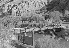
The Hurricane-La Verkin Bridge spans the Virgin River, connecting the towns of Hurricane and LaVerkin in Utah. The five-panel steel Warren pony truss spans 75 feet (23 m), and is supported by concrete-filled steel cylinder piers. It is one of the oldest Warren pony truss bridges in Utah, built in 1908 by the Midland Bridge Company.[2]
The Hurricane-LaVerkin Bridge was placed on the National Register of Historic Places on April 14, 1995.[1]
References
- 1 2 National Park Service (2010-07-09). "National Register Information System". National Register of Historic Places. National Park Service.
- ↑ Osborne, Julie W. (January 1995). "National Register of Historic Places Nomination Form: Hurricane-LaVerkin Bridge" (PDF). National Park Service. Retrieved 26 March 2014.
External links
- Historic American Engineering Record (HAER) No. UT-76, "Virgin River Warren Truss Bridge, Spanning Virgin River at Old Road southeast of State Highway 9, Hurricane, Washington County, UT", 5 photos, 1 photo caption page
| Topics | |
|---|---|
| Lists by states |
|
| Lists by insular areas | |
| Lists by associated states | |
| Other areas | |
| |
This article is issued from Wikipedia - version of the 11/30/2016. The text is available under the Creative Commons Attribution/Share Alike but additional terms may apply for the media files.