Hope-Power-Cooke Streets Historic District
|
Hope-Power-Cooke Streets Historic District | |
|
House at the corner of Manning and Hope Streets | |
  | |
| Location | Providence, Rhode Island |
|---|---|
| Coordinates | 41°49′35″N 71°23′51″W / 41.82639°N 71.39750°WCoordinates: 41°49′35″N 71°23′51″W / 41.82639°N 71.39750°W |
| Area | 41 acres (17 ha) |
| Architect | Multiple |
| Architectural style | Mid 19th Century Revival, Late 19th And 20th Century Revivals, Late Victorian |
| NRHP Reference # | 73000070 [1] |
| Added to NRHP | January 12, 1973 |
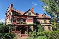
The Hope-Power-Cooke Streets Historic District is a residential historic district on the East Side of Providence, Rhode Island. Located east of Brown University, the area is compact area developed in the mid-to-late 19th century as a residential district, with a cross-section of architectural styles from the early 19th to the early 20th century. The district is bounded on the north by Angell Street, on the east by Governor Street, on the south by Power Street, and on the west by Hope Street. Cooke Street is the main thorough fare running through the center of the district, which is six blocks long and two wide. The district abuts the Stimson Avenue Historic District, which lies immediately to its west.[2]
The district was listed on the National Register of Historic Places in 1973.[1]
See also
References
- 1 2 National Park Service (2007-01-23). "National Register Information System". National Register of Historic Places. National Park Service.
- ↑ "NRHP nomination for Hope-Power-Cooke-Streets Historic District" (PDF). Rhode Island Preservation. Retrieved 2014-10-14.
| Topics | |
|---|---|
| Lists by states |
|
| Lists by insular areas | |
| Lists by associated states | |
| Other areas | |
| |