Hood River Bridge
| Hood River Bridge | |
|---|---|
 | |
| Coordinates | 45°43′05″N 121°29′43″W / 45.717976°N 121.495211°WCoordinates: 45°43′05″N 121°29′43″W / 45.717976°N 121.495211°W |
| Carries | Vehicles |
| Crosses | Columbia River |
| Locale | Between Hood River, Hood River County, Oregon, United States and White Salmon, Klickitat County, Washington, USA |
| Official name | White Salmon Bridge[1] |
| Other name(s) | Hood River Bridge |
| Maintained by | Port of Hood River |
| Characteristics | |
| Design | Through-truss with a vertical lift |
| Total length | 1,346.67 metres (4,418.2 ft)[1] |
| Longest span | 79.92 metres (262.2 ft)[1] |
| History | |
| Opened | December 9, 1924[1] |
 | |
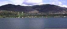
The Hood River Bridge is a truss bridge with a vertical lift that spans the Columbia River between Hood River, Oregon and White Salmon, Washington. It connects Interstate 84/U.S. Route 30 on the Oregon side with Washington State Route 14.
The bridge is currently the second oldest road bridge across the Columbia between Washington and Oregon. It was built by the Oregon-Washington Bridge Company and opened on December 9, 1924. The original name was the Waucoma Interstate Bridge.
Construction of the Bonneville Dam 23 miles (37 km) downstream forced the bridge to be altered in 1938 to accommodate the resulting elevated river levels. On December 12, 1950 the Port of Hood River purchased the bridge from the Oregon-Washington Bridge Co. for $800,000.
The bridge is operated as a toll bridge by the Port of Hood River. Currently the tolls are set to $1.00 per axle for vehicles, and $0.75 for motorcycles. Bicycles and pedestrians are prohibited from crossing the bridge.
20 piers are used to support the total length of 4,418 ft (1347 m). When closed the vertical waterway clearance is 67 ft (20m). This increases to 148 ft (45 m) when the bridge is open at a river level of 75'(which can be found at http://waterdata.usgs.gov/nwis/uv?site_no=14113290), which typically happens once or twice a month. The horizontal waterway clearance of the lift span is 246 ft (75 m).
It is located at river mile 169, between Bridge of the Gods at RM 148 and The Dalles Bridge at RM 191.
.jpg)
References
| Wikimedia Commons has media related to Hood River Bridge. |
External links
- Replacement bridge summary, Full Report (10MB).
| Crossings of the Columbia River | ||||
|---|---|---|---|---|
| ||||