Holroyd, New South Wales
| Holroyd Sydney, New South Wales | |||||||||||||
|---|---|---|---|---|---|---|---|---|---|---|---|---|---|
 Former brickworks | |||||||||||||
| Population | 1,044 (2011 census)[1] | ||||||||||||
| Postcode(s) | 2142 | ||||||||||||
| Location | 24 km (15 mi) W of Sydney CBD | ||||||||||||
| LGA(s) | Cumberland Council | ||||||||||||
| State electorate(s) | Granville | ||||||||||||
| Federal Division(s) | Parramatta | ||||||||||||
| |||||||||||||
Holroyd is a small suburb in western Sydney, New South Wales, Australia. Holroyd is located 30 kilometres west of the Sydney central business district in the local government area of the Cumberland Council. The local government area takes its name from Arthur Holroyd, first Mayor of the area, local landowner and businessman. The administrative centre is located in nearby Merrylands.
History
Arthur Todd Holroyd (1806-1887) acquired Sherwood Scrubs in 1855. Located in Merrylands, it was named after his former home in England.[2] Holroyd became a Member of Parliament for Bathurst Plains then Parramatta, and was a judge for the NSW Supreme Court, had completed one year medical residency in London and was a keen businessman. He was respected and powerful and was on many and varied boards and committees. He became the first mayor of Holroyd Council, then the Municipality of Prospect & Sherwood, from 1872-1927 with only 250 ratepayers for first 9 years. He made clay pipes for drainage at Sherwood Scrubs and introduced drainage to the local area. He also encouraged the rail line to Parramatta Junction.

The suburb of Holroyd was created when the New South Wales Geographical Names Board sought to define suburb boundaries in 1999. Holroyd Council Local Government Area did not have a specific suburb of the same name and had to create one to satisfy the State Government requirements as carried out by the Geographical Names Board. The suburb named Holroyd was gazetted in 1999 with boundaries being Walpole Street (north), Neil Street (south) the railway line (east) and Pitt Street (west). There was a change to the boundary in 2001 with the northern boundary extended to the freeway.[3]
Landmarks
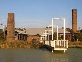
The historic Goodlet and Smith Brickpit sites have now been redeveloped into Holroyd Gardens Park on the site of a clay pit that was later filled. Holroyd Gardens Estate which is a medium density development that includes the remaining heritage brickwork kilns and associated buildings.
Population
At the 2011 census, there were 1,044 residents in Holroyd. Almost 70% of people were born outside of Australia, with the top countries of birth being India 8.4%, China 7.2%, Afghanistan 5.5%, Lebanon 3.9% and Philippines 3.7%. About three quarters of people spoke a language other than English at home. The most common other languages spoken were Arabic 10.2%, Mandarin 8.3%, Dari 4.0%, Hindi 3.8% and Cantonese 3.3%. The top responses for religious affiliation were Catholic 23.4%, Islam 16.5% and No Religion 14.7%.[1]
References
- 1 2 Australian Bureau of Statistics (31 October 2012). "Holroyd (State Suburb)". 2011 Census QuickStats. Retrieved 10 May 2013.
- ↑ The Book of Sydney Suburbs, Compiled by Frances Pollon, Angus & Robertson Publishers, 1990, Published in Australia ISBN 0-207-14495-8, page 170
- ↑ NSW Geographical Names Board, Bathurst NSW
| Wikimedia Commons has media related to Holroyd, New South Wales. |
Coordinates: 33°49′52″S 150°59′49″E / 33.831°S 150.997°E