Historic bridges of New South Wales
This list documents historical bridges located in New South Wales, Australia. Road, rail and pedestrian bridges are listed. Generally bridges built before WWII (1939) have been included in this list.
Historical context
Bridge construction in New South Wales starts with the needs of the first settlers and continues through to the present day with advanced bridge design. The infant colony had limited expertise and limited materials, as time passed techniques and materials were developed that allowed greater spans to be crossed and therefore expansion of the colony into otherwise inaccessible areas.
The NSW Public Works Department was under pressure from a cash strapped government to produce as much road and bridge work for as little cost as possible.[1] The cheapest bridge was the timber truss which could be built with local timber.
All bridges are unique, in the end the bridge that is built depends on the technology, expertise, materials and need to gain access to an area.
At the time of early settlement (1788 onwards) NSW was very isolated from the technological advances being developed in Europe and North America. Materials such as cast iron were unavailable to early colonial NSW bridge builders. NSW bridge builders had to rely on their own resourcefulness, bred of isolation, distance and the unique environment.
New South Wales's unusual environment results in unusual, and extreme river flows, almost no flow for most of the year, some flow each year and extreme floods around once a decade. Inland the cause is the low pressure system coming over the continent, due to a large high pressure of the Indian Ocean. This often occurs at summer, at which time it causes cyclone season, although it can occur at any time of year (but not inducing cyclones). At the coast, the cause is the "east coast low", which occurs at similar places at the eastern edge of a number continents, and sees the continent's normal high pressure systems becomes one large and stationary system, perhaps due to doldrums over the west coast's ocean, at which time the global trade winds deviate, inducing the low pressures at polar and tropical latitudes to connect along the east coast, producing a trough situation that mimics the tropical monsoon. An east coast low rain event can occur at any time of the year. Early settlers often replaced washed out bridges with a similarly rudimentary structure, only to see it also washed away in a heavy rain event. The government came to see that this was a major problem holding back economic development in New South Wales.
In solving these problems, colonial NSW embraced the innovations produced by others and adapted them successfully to the unique situations presented. There are examples of some very fine 19th-century bridge engineering provided for the railway expansion, conceived mainly by British engineers working in the then isolation of the Australian inland, and we have well-developed examples of many of the newer European techniques such as cable-stayed bridges.
Australia developed around coastal communities with rudimentary road systems to inland settlements. The early years saw early bridge technology limited very much to the 18th-century European technology of masonry arches and cast iron, the latter still in its infancy and not produced to any great extent in New South Wales.
NSW at the time of early settlement had an abundance of convict labour and had a need for rapid construction. In a country heavily timbered this led to basic timber structure bridges but as the Colony gained stability the government looked towards more permanent structures and, as the skills for quarrying and stone dressing became available, masonry bridges began to be designed and built. As all metal materials had to be imported, iron bridges were rarely appropriate and were in any case still too novel for colonial application. Iron bridges were only used for major crossings on important corridors.[2]
Timber truss bridges, and timber bridges generally were so common that NSW was known to travellers as the "timber bridge state".[1]
The following list illustrates the development of New South Wales bridge construction techniques. The list commences from the earlier constructions through to the later developments.
New South Wales historic bridges
Sorted by date
| Built | Name | Location | Image | Construction type | Length | Use | In use | Comments | Ref | Coords |
|---|---|---|---|---|---|---|---|---|---|---|
| 1833 | Lennox Bridge | Glenbrook | Lennox_Bridge-1.jpg) |
stone arch | 6 metres (20 ft) | Road | Yes | see article | 33°45′15″S 150°37′56″E / 33.75417°S 150.63222°E | |
| 1836 | Lansdowne Bridge | Lansvale |  |
stone arch | 33.5 m | Road | Yes | largest span stone arch bridge in Australia | [3] | 33°53′24″S 150°58′01″E / 33.89000°S 150.96694°E |
| 1839 | Lennox Bridge | Parramatta |  |
stone arch | 27 metres (89 ft) | Road | Yes | [4] | 33°48′39″S 150°00′16″E / 33.81083°S 150.00444°E | |
| 1858 | Pyrmont Bridge | Darling Harbour |  |
Ironbark timber with steel centre swing span | 369 metres (1,211 ft) | Road | Yes | one of the largest swing spans in the world at the time of its construction and it was one of the first to be powered by electricity. Now pedestrian and bicycles only | [5] | 33°52′14″S 151°12′02″E / 33.87056°S 151.20056°E |
| 1863 | Picton Viaduct | Picton | 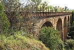 |
stone arch | Rail | Yes | spans Stonequarry Creek | 34°10′40″S 150°36′42″E / 34.17778°S 150.61167°E | ||
| 1863 | Menangle Railway Bridge | Menangle |  |
Rail | Yes | see article | 34°07′05″S 150°44′37″E / 34.11806°S 150.74361°E | |||
| 1867 | Victoria Bridge | Penrith |  |
wrought iron girder | Road | Yes | also known as Nepean River Bridge | see article | 33°44′46″S 150°40′54″E / 33.74611°S 150.68167°E | |
| 1867 | Knapsack Viaduct | Lapstone |  |
stone arch | Rail (Later road) |
Yes | Now pedestrian only | see article | 33°46′00″S 150°37′00″E / 33.76667°S 150.61667°E | |
| 1867 | Prince Alfred Bridge | Gundagai |  |
underslung wrought iron Warren continuous truss & timber approaches | 921 metres (3,022 ft) | Road | No | possibly oldest iron truss in NSW | [6] | 35°04′25″S 148°06′26″E / 35.07361°S 148.10722°E |
| 1869 | Zig Zag Viaducts | Clarence |  |
Stone | Rail | Yes | 33°28′19″S 150°11′43″E / 33.471939°S 150.195326°E | |||
| 1869 | Farmers Creek Viaduct | Bowenfels | Stone | Rail | No | 33°28′22″S 150°07′38″E / 33.472773°S 150.127141°E | ||||
| 1870 | Marrangaroo Creek Viaduct | Marrangaroo | Stone | Rail | No | 33°26′17″S 150°06′44″E / 33.438177°S 150.112180°E | ||||
| 1870 | Denison Bridge | Bathurst | |
steel American Pratt truss | Road | Yes | Now pedestrian only | see article | 33°25′02″S 149°35′31″E / 33.41722°S 149.59194°E | |
| 1870 | Mudgee Road Bridge | Wallerawang | Stone | Road | Yes (private) | 33°24′47″S 150°05′54″E / 33.412946°S 150.098262°E | ||||
| 1870 | Coxs River Bridge | Wallerawang | Stone | Rail | No | 33°24′20″S 150°04′59″E / 33.405507°S 150.083188°E | ||||
| 1874 | Windsor Bridge | Windsor | Road | Yes | [7] | 33°36′11″S 150°49′20″E / 33.603163°S 150.822183°E | ||||
| 1881 | Nowra Bridge | Nowra | 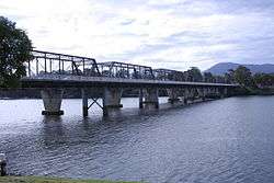 |
Steel Whipple Truss | 342 metres (1,122 ft) | Road | Yes | see article | 34°51′51″S 150°36′07″E / 34.86417°S 150.60194°E | |
| 1881 | Gladesville Bridge (the 1881 bridge) | Drummoyne | .jpg) |
Road | No | Demolished when the new road bridge opened in 1964 | see article | 33°50′32″S 151°08′35″E / 33.84222°S 151.14306°E | ||
| 1881 | Dubbo Rail Bridge | Dubbo |  |
wrought iron lattice girder bridge | Rail | Yes | [8] | 32°14′38″S 149°35′39″E / 32.24389°S 149.59417°E | ||
| 1882 | Peel River Bridge | Tamworth | iron lattice girder | main 159ft - over 3000ft | Rail | Yes | [9] | 31°05′06″S 150°55′23″E / 31.084959°S 150.923141°E | ||
| 1885 | Como Bridge (formerly Como Railway Bridge) | Como - Oatley spanning Georges River | lattice girder bridge | Pedestrian, Viaduct (formerly Rail) | Yes | "The Como Rail Bridge is significant as the longest single track lattice girder bridge in New South Wales and is a rare example of this type Historically, the bridge contributed to the opening up of the southern suburbs of Sydney in the 1880s. While the rail infrastructure has largely been removed from the bridge, it continues to serve an important function, supporting the Woronora to Penshurst Water Supply Pipeline, part of Sydney's fifth water supply system. It also provides an important pedestrian link across the Georges River." | [10] | 33°59′42.3″S 151°04′14.8″E / 33.995083°S 151.070778°E | ||
| 1886 | three trestles | Main North Line | timber Queen post truss viaduct on wooden trestles | Rail | No | three of only five bridges built | [11] | 29°38′17″S 151°46′50″E / 29.638055°S 151.780665°E29°34′55″S 151°48′09″E / 29.581967°S 151.802520°E29°12′01″S 152°01′00″E / 29.200395°S 152.016721°E | ||
| 1886 | Meadowbank Bridge | Meadowbank | 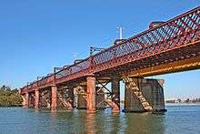 |
Truss Bridge | Rail | Yes | Now bicycles and pedestrians only. New John Whitton Bridge was built to replace the original bridge in 1980. | [12] | 33°49′19″S 151°05′20″E / 33.82194°S 151.08889°E | |
| 1888 | Brewarrina Bridge | Brewarrina | wrought iron lift bridge with timber beam approaches | 91 metres (299 ft) | Road | Yes | Now pedestrian only | [13] | 29°56′51″S 146°51′48″E / 29.94750°S 146.86333°E | |
| 1888 | Mulga St Bridge | Oatley | Double stone culvert | Road | Yes | Now covered with modern roadwork, the stonework is still visible from Myles Dunphy Reserve. | [14] | 33°58′49.8″S 151°4′40.0″E / 33.980500°S 151.077778°E | ||
| 1888 | Sunnyside | Tenterfield | timber Queen post truss viaduct on stone trestles | rail | no | [15]
Sunnyside rail bridge over Tenterfield Creek |
28°59′08″S 151°56′58″E / 28.985426°S 151.949414°E | |||
| 1891 | Murrumbidgee River Rail | Wagga Wagga |  |
wrought iron lattice truss | Rail | No | Removed in 2007 | see article | 35°6′56.53″S 147°22′58.16″E / 35.1157028°S 147.3828222°E | |
| 1895 | Wilcannia Bridge | Wilcannia | steel truss bridge | Road | No | Accessible to public. Used to carry Barrier Highway and spans over Darling River. | [16] | 31°33′36.7″S 143°22′46.7″E / 31.560194°S 143.379639°E | ||
| 1895 Mar | Tharwa Bridge | Tharwa | wooden Allan Truss | Road | Yes | see article | 35°30′31″S 149°04′14″E / 35.508579°S 149.070539°E | |||
| 1895 Nov | Hampden Bridge | Wagga Wagga | 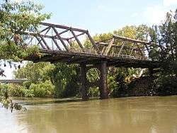 |
wooden Allan Truss | 100.5 metres (330 ft) | Road | Yes | Closed to public. To be demolished in 2013. | see article | 35°6′2.53″S 147°22′6.68″E / 35.1007028°S 147.3685222°E |
| 1897 | Victoria Bridge | Picton | wooden Allan Truss | 80 metres (260 ft) | Road | Yes | tallest trestle in NSW | see article | 34°10′49″S 150°36′38″E / 34.18028°S 150.61056°E | |
| 1897 | Wallaby Rocks Bridge (Turon River) | Wallaby Rocks | Allan timber truss | 106.7 metres (350 ft) | Road | Yes | [17] | 33°04′26″S 149°38′59″E / 33.07389°S 149.64972°E | ||
| 1898 | Hampden Bridge | Kangaroo Valley |  |
suspension with sandstone turrets | Road | Yes | see article | 34°43′40″S 150°31′16″E / 34.72778°S 150.52111°E | ||
| 1898 | Morpeth Bridge | Morpeth | Allan truss | 820 feet (250 m) | Road | Yes | see article | 32°43′26″S 151°37′36″E / 32.7237684729°S 151.6265683110°E | ||
| 1901 | Hinton Bridge | Hinton | |
Allan truss | 178.6 metres (586 ft) | Road | Yes | [18] | 32°42′51″S 151°38′52″E / 32.71417°S 151.64778°E | |
| 1901 | De Burghs Bridge (the 1901 bridge) | West Pymble | .jpg) |
Road | No | Replaced by new road bridge in 1967. Old bridge destroyed by Bushfire in January 1994 | see article | 33°46′32.8″S 151°8′12″E / 33.775778°S 151.13667°E | ||
| 1902 | Gundagai Rail Bridge | Gundagai |  |
timber Howe deck trusses | 819 metres (2,687 ft) | Rail | No | over Murrumbidgee River | [19] | 33°04′23″S 148°06′17″E / 33.07306°S 148.10472°E |
| 1903 | St Albans Bridge | St Albans |  |
DeBurgh timber truss | Road | Yes | [20] | 33°17′39″S 150°58′22″E / 33.29417°S 150.97278°E | ||
| 1903 | Maldon suspension bridge | Maldon | Road | No | [21] | 34°12′08″S 150°37′56″E / 34.202084°S 150.632313°E | ||||
| 1911 | Scabbing Flat Bridge | Dubbo | timber 'dare type' truss | Road | Yes | [22] | 32°25′50″S 148°48′36″E / 32.430650°S 148.809958°E | |||
| 1914 | Mungindi Bridge | Mungindi |  |
timber 'dare type' truss | Road | Yes | To be replaced by a new bridge which is under construction | 28°58′33″S 148°59′05″E / 28.97583°S 148.98472°E | ||
| 1916 | Rawsonville Bridge | Dubbo | timber 'dare type' truss | Road | Yes | [23] | 32°11′28″S 148°26′59″E / 32.191235°S 148.449709°E | |||
| 1918 | Fullers Bridge | Chatswood West |  |
Road | Yes | see article | 33°47′34″S 151°09′25″E / 33.79278°S 151.15694°E | |||
| 1924 | Mulwala Bridge | Mulwala |  |
Steel Pratt Truss | Road | Yes | see article | 36°00′15″S 146°00′15″E / 36.00417°S 146.00417°E | ||
| 1924 | Roseville Bridge (the 1924 bridge) | Roseville Chase | Road | No | Replaced by new road bridge in 1966. Used as a pedestrian bridge until it was demolished in 1974. | see article | 33°46′27″S 151°12′18.5″E / 33.77417°S 151.205139°E | |||
| 1927 | Subway Lane bridge | Homebush | Rail | Yes | [24] | 33°51′58″S 151°05′02.5″E / 33.86611°S 151.084028°E | ||||
| 1929 | Tom Uglys Bridge (the 1929 bridge) | Blakehurst |  |
Truss bridge | 499 metres (1,637 ft) | Road | Yes | see article | 34°00′12″S 151°06′48″E / 34.00336111°S 151.1133778°E | |
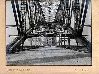
| 1932 | Sydney Harbour Bridge | Sydney |  |
steel through arch bridge | Road | Yes | see article | 33°51′29″S 151°12′39″E / 33.85806°S 151.21083°E | ||
| 1932 | Grafton | Grafton |  |
Bascule | Road (upper deck) and Rail (lower deck) | Yes | see article | 29°41′52.6″S 152°56′31.5″E / 29.697944°S 152.942083°E | ||
| 1935 | Ryde Bridge (the 1935 bridge) | Ryde |  |
lift bridge | Road | Yes | see article | 33°49′25″S 151°05′42″E / 33.82361°S 151.09500°E | ||
| 1939 | Long Gully Bridge (Northbridge) | Northbridge |  |
concrete arch | Road | Yes | Rebuilt and replaced the 1892 bridge | [25] | 33°48′59″S 151°12′44″E / 33.81639°S 151.21222°E | |
Allan type truss
The Allan truss bridge is named after Percy Allan, a famous Australian engineer who designed this bridge type. His design consisted of vertical and diagonal arrangements comprising a combination of timber and iron elements. The timber elements were designed to be in compression and the iron elements in tension. Allen's design followed extensive testing of Australian hardwoods by Prof. Warren and his early engineering students at Sydney University. The timber used was mostly ironbark because of its high strength. Other features of Allan's truss design included design to minimize later maintenance and/or replacement of elements. For this reason the trusses were built in pairs to facilitate work on a particular element without requiring the whole bridge to be supported, as was the case with previous timber designs. Allan's design was very cost-effective.
The Hampden Bridge in New South Wales Australia was the first of a larger style bridge to be built on Percy Allan’s design[26] with the Tharwa Bridge pre-dating it.
Dare type truss
Harvey Dare was a leading engineer in the Public Works Department, and a prominent figure in early 20th century NSW. He was a designer of bridges and he developed the Dare Truss which was similar to the Allan Truss but contained improvements which make them stronger and easier to maintain. This engineering enhancement represents a significant evolution of the design of timber truss bridges, and gives Dare trusses some technical significance. Dare Trusses were the fifth of the five stages of evolution of timber truss road bridges in NSW.[1]
In 1998 there were 27 surviving Dare trusses in NSW of the 40 built, and 82 timber truss road bridges survive from the over 400 built.[1]
See also
"Bridges and Roads in New South Wales". Unique Cars and Parts.
References
- 1 2 3 4 "Heritage & Conservation Register". NSW Government-Roads and Traffic Authority. Retrieved 24 Feb 2011.
- ↑ "Technology in Australia 1788-1988". University of Melbourne. Retrieved 23 Feb 2011.
- ↑ "Lansdowne Bridge over Prospect Creek". Office of Environment & Heritage. NSW Government. Retrieved 12 Mar 2011.
- ↑ "Lennox Bridge, Parramatta". Heritage and Conservation Register, Roads & Maritime Services. Government of New South Wales. 14 May 2009. Retrieved 12 January 2015.
- ↑ "Pyrmont Bridge: A symbol of Australia's industrial history". Sydney Harbour Foreshore Authority. Government of New South Wales. Retrieved 14 January 2015.
- ↑ "Heritage Register-Prince Alfred Bridge". NSW Government-Roads & Traffic Authority. Retrieved 7 Mar 2011.
- ↑ "Windsor Bridge replacement- Road Projects". Roads and Maritime Services. Retrieved 29 Apr 2013.
- ↑ "Dubbo Railway Precinct". NSW Environment & Heritage. Retrieved 29 Apr 2013.
- ↑ "The Great Northern Railway Extension.". The Sydney Mail And New South Wales Advertiser. XXXIII, (1123). New South Wales, Australia. 14 January 1882. p. 68. Retrieved 29 November 2016 – via National Library of Australia.
- ↑ "Como Rail Bridge". Sydney Water. Retrieved 28 Nov 2016.
- ↑ "Yarraford rail bridge over Beardy Waters". Office of Environment & Heritage. NSW Govt.
"Dundee rail bridge over Severn River". Office of Environment & Heritage. NSW Govt.
"Sandy Flat, Bluff River Underbridge". Office of Environment & Heritage. NSW Govt. - ↑ "Meadowbank (Parramatta River) Underbridge". NSW Environment & Heritage. Retrieved 29 Apr 2013.
- ↑ "Heritage Register-Brewarrina Bridge over Barwon River". NSW Government-Roads & Traffic Authority. Retrieved 7 Mar 2011.
- ↑ "Hurstville". Sydney Morning Herald, 22 Sep 1888 via Trove. Retrieved 28 Nov 2016.
- ↑ "Sunnyside rail bridge over Tenterfield Creek". Office of Environment & Heritage. NSW Govt.
- ↑ "Barrier Highway (NSW)". Ozroads. Retrieved 1 May 2013.
- ↑ "Bridge over Turon River at Wallaby Rocks". Office of Environment & Heritage. NSW Government. Retrieved 7 Mar 2011.
- ↑ "Hinton Bridge - Road Projects". Roads and Maritime Services. Retrieved 14 May 2013.
- ↑ "Gundagai rail bridge over Murrumbidgee River". Office of Environment & Heritage. NSW Government. Retrieved 7 Mar 2011.
- ↑ "Heritage Register-St Albans Bridge". NSW Government-Roads & Traffic Authority. Retrieved 7 Mar 2011.
- ↑ "MINISTERS AT MALDON.". The Sydney Morning Herald (20,283). New South Wales, Australia. 13 March 1903. p. 4. Retrieved 2 October 2016 – via National Library of Australia.
- ↑ "Heritage Register-Scabbing Flat". NSW Government-Roads & Traffic Authority. Retrieved 21 Feb 2011.
- ↑ "Heritage Register-Rawsonville". NSW Government-Roads & Traffic Authority. Retrieved 21 Feb 2011.
- ↑ "Reason for train delays proves a bridge too far". Sydney Morning Herald. Retrieved 12 May 2013.
- ↑ "Long Gully Bridge Appendix F Landscape and visual impact assessment" (PDF). NSW Government-Roads & Traffic Authority. Retrieved 12 May 2013.
- ↑ "Types Of Truss Bridges". Bozzle Website. Retrieved 24 Feb 2011.