Haulover Park
| Haulover Park | |
|---|---|
|
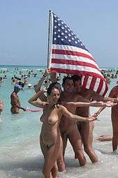
Trial for world record in skinny-dipping, 2009 | |
| Type | Municipal |
| Location | Haulover Beach, Miami-Dade County, Florida, United States |
| Area | 99 acres (40 ha) |
| Created | 1948 |
| Operated by | Miami-Dade Parks and Recreation Department |
| Website | Haulover Park |

Haulover Park is a 99-acre (40 ha) urban park in metropolitan Miami, just north of Bal Harbour, Florida. The park is located on a shoal between the Atlantic Ocean and Biscayne Bay, just north of the Broad Causeway (SR 922) and Collins Avenue.
History
The Dade County Commission procured the beach front property in 1940 following a lobbying effort for a $2 million municipal bond ($33.8 million, adjusted for current inflation) by county commissioner Charles H. Crandon for the purchases of northern Key Biscayne (what became Crandon Park) and the beach north of Baker's Haulover Inlet, then called Ocean Beach.[1]
Construction began on beach facilities in 1941, halted soon afterward due to funding holds following the onset of World War II. Work on the property resumed in 1945,[2] and park was renamed Haulover Park in January 1947, opening to the public the following year in late 1948.[3][4]
The northern 0.4-mile (0.6 km) of the 1.5-mile (2.4 km) shoreline is a nude beach officially recognized and approved by the government of Miami-Dade County. The clothing-optional section was first designated by South Florida Free Beaches, a local naturist organization, in July 1991. The county at first tolerated but did not sanction the usage; it eventually allowed the installation of permanent signs marking the clothing-optional area, which were installed in December 1993. The clothing-optional area features lifeguards and a food and umbrella rental concession. It is the largest public nudist beach in the U.S. and attracts 1.3 million visitors per year.[5]
Facilities
The park features a marina, six tennis courts, and a nine-hole 27-par golf course. On the southern end of the park are several picnic recreational areas.
Gallery
-

Entrance to Haulover Park northward on Collins Avenue
-

View on Bal Harbour across Baker's Haulover Inlet
-

Patrons enjoying the clothing-optional part of the beach
-

Nude bathers
-
World record in skinny dipping at Haulover Beach.
References
- Notes
- ↑ "Dade Owned Ocean Beach Urged in Book". Miami Daily News. 9 May 1940. Retrieved 4 May 2011.
- ↑ "Work Begun After 3-Year War Halt". Miami Daily News. 27 August 1945. Retrieved 4 May 2011.
- ↑ "North Beach Park Gets New Name–Haulover Beach". Miami Daily News. 21 January 1947. Retrieved 4 May 2011.
- ↑ "Fourth Beach Causeway Proposal is Revived". Miami Daily News. 22 December 1948. Retrieved 4 May 2011.
- ↑ Clothing-optional holidays: Nudists on cruises, economist.com.
- Bibliography
- County Park Department web site for Haulover Park - retrieved May 16, 2010
- USGS Geographic Names Information System Feature Detail Report - Haulover Beach Park - accessed May 16, 2010
- Historical Haulover page - accessed May 16, 2010
- South Florida Free Beaches
- "You may encounter nude bathers" sign
External links
Coordinates: 25°54′40″N 80°07′17″W / 25.911165°N 80.121324°W