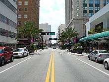
The CBD consists of a mix of historic low and mid-rise buildings, as well as newer high-rise buildings.
Central Business District (CBD) is the historic city center of what has become Greater Downtown Miami,[1] in Miami, Florida, United States. It is generally bound by Biscayne Boulevard, Bayfront Park and Museum Park on the east, the Miami River to the south, North 6th Street to the north, and Interstate 95 to the west.[2][3] While it is technically Miami's official "downtown", the term "Downtown Miami" has come to refer to a much larger 3.8-square-mile (10 km2) area along the bay from the Rickenbacker Causeway to the Julia Tuttle Causeway. It is also distinct from the financial district, which in this case is neighboring Brickell to the south. However, the downtown core has over 5,000,000 square feet (460,000 m2) of office space, including more than fifteen buildings with greater than 100,000 sq ft (9,300 m2) of floor space.[4]
History
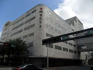
The Burdine's Department Store, built in 1912, is located in the very heart of Miami at
Miami Avenue and
Flagler Street, which divide the Miami Grid street numbering pattern.
The City of Miami was officially incorporated as a city on July 28, 1896 with a population of just over 300.[5] Downtown is the historic heart of Miami, and along with Coconut Grove, is the oldest settled area of Miami, with early pioneer settlement dating to the early 19th century. Urban development began in the 1890s with the construction of the Florida East Coast Railway by Standard Oil industrialist Henry Flagler down to Miami at the insistence of Julia Tuttle. Flagler, along with developers such as William Brickell and George E. Merrick helped bring developer interest to the city with the construction of hotels, resorts, homes, and the extension of Flagler's rail line. Flagler Street, originating in Downtown, is a major east-west road in Miami named after the tycoon; the Julia Tuttle Causeway, crossing Biscayne Bay just north of Downtown in Edgewater, is named in honor of Tuttle.
Character
The CBD has long been dense with retail and office space, as well as some lofts and apartments, but recently has seen large scale high-rise residential development as during Miami housing market booms in the aughts and continuing again in the 2010s. Though the historically wealthy suburb of Brickell to the south remains much more popular, downtown has seen urban buildings such as The Loft, The Loft 2, and Centro Lofts which have no built-in parking as well as more traditional luxury condos such as the bayfront 50 Biscayne and Vizcayne. Wolfson Campus, the primary (but not largest) campus of Miami-Dade College is located in the CBD, with about ten buildings around NE 5 Street and NE 2 Ave. The historic Flagler Street, which is the north-south divider of the street grid in Miami-Dade, may undergo a major renovation from the Miami River to the terminus at Biscayne Boulevard starting by 2016. The project was publicized in 2014 and has faced several delays.[6]
Transportation
The Metromover Inner Loop is located entirely within the CBD, as is Metrorail's Government Center station, where the rapid transit and people mover systems meet. This is the busiest station for both systems and sees over 15,000 riders on an average weekday. It is located on the west side of downtown in the Government Center area, which has a large concentration of city, county, state, and federal offices. The area is also heavily served by the Metrobus (Miami-Dade County) and Miami Trolley, as well as taxis ridesharing and carsharing services such as Uber and Car2Go. Downtown Miami as defined by Walk Score which includes Brickell and Omni, is considered "very walkable" and as having "world-class public transportation", as well as being "very bikeable".[7]
Gallery
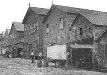
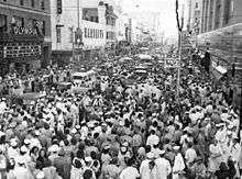
Historic
| Late 19th thru 20th centuries |
|---|
| Miami Avenue in 1896, when approximately 400 men voted to incorporate Miami as a city |
|
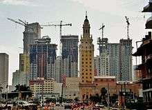
Present
| Since 2000 |
|---|
| View of downtown over Biscayne Bay with larger buildings marked. |
| As the CBD has "Manhattanized" along with the Greater Downtown area, a phenomenon known as the "Biscayne Wall" has emerged. |
|
See also
References
- ↑ "Greater Downtown Miami" (PDF). Miami Downtown Development Authority. July 12, 2013. Retrieved November 23, 2015.
- ↑ "Central Business District DDA Subdistrict" (PDF). Miami Downtown Development Authority. July 11, 2013. Retrieved November 23, 2015.
- ↑ "Miami Downtown Development Authority: Subdistrict Boundaries" (PDF). Miami Downtown Development Authority. July 5, 2013. Retrieved November 23, 2015.
- ↑ "Downtown Miami's Central Business District Office Buildings" (PDF). Miami Downtown Development Authority. February 22, 2010. Retrieved November 23, 2015.
- ↑ Williams, Linda K.; George, Paul S. "South Florida: A Brief History". Historical Museum of South Florida. Retrieved August 24, 2009.
- ↑ Lackner, Catherine (October 20, 2015). "Flagler Street upgrade faces two hurdles". Miami Today. Retrieved November 24, 2015 – via miamitodaynews.com.
- ↑ "Downtown". walkscore.com. Walk Score. Retrieved November 23, 2015.
External links
Coordinates: 25°46′30″N 80°11′28″W / 25.775°N 80.191°W / 25.775; -80.191