Hatton, Warrington
| Hatton | |
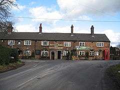 The Hatton Arms public house, Hatton |
|
 Hatton |
|
| OS grid reference | SJ597825 |
|---|---|
| Civil parish | Hatton |
| Unitary authority | Warrington |
| Ceremonial county | Cheshire |
| Region | North West |
| Country | England |
| Sovereign state | United Kingdom |
| Post town | WARRINGTON |
| Postcode district | WA4 |
| Dialling code | 01925 |
| Police | Cheshire |
| Fire | Cheshire |
| Ambulance | North West |
| EU Parliament | North West England |
| UK Parliament | Warrington South |
Coordinates: 53°20′17″N 2°36′14″W / 53.338°N 2.604°W
Hatton is a civil parish and a village in Warrington, Cheshire, England, located to the south of Warrington town centre.
It lies on the B5356 road between the villages of Daresbury and Stretton.[1] It has one public house, The Hatton Arms. This is a Grade II listed building which formerly incorporated a post office and a village store.[2]
See also
References
- ↑ Bolton, Wigan & Warrington: Explorer 276 map, Ordnance Survey.
- ↑ Historic England, "The Hatton Arms, Hatton (1329768)", National Heritage List for England, retrieved 7 February 2013
External links
![]() Media related to Hatton, Warrington at Wikimedia Commons
Media related to Hatton, Warrington at Wikimedia Commons
Cheshire Portal | |
| Unitary authorities | |
| Major settlements | |
| Rivers | |
| Topics | |
This article is issued from Wikipedia - version of the 1/23/2016. The text is available under the Creative Commons Attribution/Share Alike but additional terms may apply for the media files.