Haslington
| Haslington | |
 Wesleyan Methodist Church, Haslington |
|
 Haslington |
|
| Population | 6,536 (2011 Census)[1] |
|---|---|
| OS grid reference | SJ734558 |
| Civil parish | Haslington |
| Unitary authority | Cheshire East |
| Ceremonial county | Cheshire |
| Region | North West |
| Country | England |
| Sovereign state | United Kingdom |
| Post town | Crewe |
| Postcode district | CW1 |
| Dialling code | 01270 |
| Police | Cheshire |
| Fire | Cheshire |
| Ambulance | North West |
| EU Parliament | North West England |
| UK Parliament | Crewe and Nantwich |
| Website | http://www.haslington.org |
Coordinates: 53°05′56″N 2°23′53″W / 53.099°N 2.398°W
Haslington is a village and civil parish in the unitary authority of Cheshire East and the ceremonial county of Cheshire, England. It lies about 2 miles (3 km) north-east of the much larger railway town of Crewe and approximately 4 miles (6.5 km) south of Sandbach. The village was originally bisected by the A534 road that links Crewe with Sandbach, however, this road has now been re-routed to bypass the village to the north-west. The village is also a close neighbour to a number of small towns and villages (including Alsager, Wheelock, Winterley), and is approximately 6 miles (9 km) from the Elizabethan market town of Nantwich.
History
Haslington is not mentioned in the Domesday Book of 1086, so it is presumed that either the village came into existence afterwards, or was insignificantly small.[2] The earliest mention of Haslington is in 1256, when it was called "Hesinglinton". The name is possibly derived from the phrase "tun among hazels", or "enclosure amongst hazel trees". Often, with settlement names ending with "tun" or "ton", such as Haslington, this indicates origins of a farm enclosed with a moat or fence.[3] Later variations of the name were 'Halinton'; (1292, 1536), "Hasillinton" (1280), "Haselin(g)ton(e)" (1293 to 1586), and "Hass(e)lyn(g)ton" (1307 to 1432).[4] Alternatively it has been suggested the Haslington's name derives from Thomas de Heslynton, an archer in the King's Bodyguard and a resident of Haslington, however this version of events is often discredited due to de Heslynton's life being after the earliest mentions of the village.[2]
In the reign of Edward I, the Barony of Wich-Malbank (now known as Nantwich) was divided up between the heirs of the last Baron who held that title, William. Haslington was given to Auda Vernon of Shipbrooke, whose descendants included the founder and early residents of Haslington Hall.[5]
During the First English Civil War, on 27 December 1642, there was a skirmish between the Royalists and the Parliamentarians that took place on the southern outskirts of the village at a place called Slaughter Hill. The, Parliamentarians—also known as the Roundheads—won the battle. Local legend says the battle caused the brook nearby to turn red from the blood spilt.[6] A sword was found embedded in the bank of Valley Brook.[6] Although the macabre name Slaughter Hill suggests it may be named after this skirmish, it may be a corruption of "Sloe Tree Hill". Blackthorn (Prunus spinosa), the fruit of which are sloes, can still be found in the hedgerows down the lane named Slaughter Hill, which adjoins with the neighbouring civil parish of Crewe Green.[7]
Governance
Haslington was originally a chapelry within the ancient parish of Barthomley. It was made a separate civil parish in 1866.[8] The parish council has 15 councillors, split between three parish wards: Haslington, Winterley, and Oakhanger.[9][10] Haslington is the largest of the three wards.[11]
From 1974 the civil parish was served by Crewe and Nantwich Borough Council, which was succeeded on 1 April 2009 by the new unitary authority of Cheshire East.[12] Haslington falls in the parliamentary constituency of Crewe and Nantwich,[13] which has been represented by Conservative MP Edward Timpson since a by-election in May 2008 following the death of the long-standing Labour MP Gwyneth Dunwoody,[14] a seat which she had held since the constituency's creation in 1983.
Geography
The area around Haslington is primarily arable land, though also some dairy farms. The land to the east in Oakhangar consists of peat, whereas in the west, clay.[11] There are two main areas of peat: White Moss and Oakhangar Moss, the latter of which being a Site of Special Scientific Interest.[11] The parish of Haslington features 110 miles of hedges, 10,000 trees and 60 public paths.[11] There was an original Haslington Hall that pre-dated the current one, built around 1220, that was moated.[3] The moat and Hall gradually crumbled away and became a mere, which was only filled in the 20th century. The mere was near what is now Mere Street, off Crewe Road.[15] The nearby village of Winterley, within Haslington's parish, is home to Winterley Pool, a modest lake by the roadside of Crewe Road.
Areas of land within Haslington, and also nearby Crewe Green and Crewe, are owned by the Duchy of Lancaster.[16] The Duchy of Lancaster is a royal duchy, which provides income to the monarch; the Duke of Lancaster is Elizabeth II.
Haslington is situated 2 miles (3 km) north-east of Crewe, and 4 miles (6.5 km) south of Sandbach. The route from Crewe to Sandbach used to be straight through the village, until the construction of a bypass (A534) to the north west of the village. Transport links in the form of bus routes connect the village from Crewe to Northwich, Macclesfield and Hanley all passing through the village. Haslington's close proximity to Crewe also means residents have access to Crewe railway station, which has frequent train services to cities such as Manchester and London. Additionally, Haslington is relatively close to the M6 motorway, with junctions 16 and 17 serving Crewe and Sandbach, respectively. A small section of the motorway does actually pass through a sparsely-populated area of the parish to the far east by its border. With its various transport links available, Haslington can be considered a dormitory village.
Demography
Haslington has undergone a large, rapid expansion over the last 25 years, thanks to the redevelopment of Crewe. The 2011 UK census gives the population as being 6,536, of which 3,164 are male, and 3,372 are female. [17] They are living in 2,706 households.[18]
Historically, the population was as given the following table:
| Year | 1801 | 1851 | 1901 | 1951 | 2001 | 2011 |
|---|---|---|---|---|---|---|
| Population | 667 | 1153 | 1791 | 3223 | 6430 | 6536 |
(source: UK and Ireland Genealogy Site and 2011 Census).
Landmarks
Haslington Hall
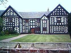
Haslington Hall is a mainly timber framed building situated to the east of the village. Some of its structure dates back to 1480 but it is principally of 1545 with later additions. It was founded by the Vernon family and, in particular, Admiral Sir Francis Vernon who was involved in defeating the Spanish Armada. Notable more recent residents include Air Commodore Dame Felicity Peake, the first director of the Women's Royal Air Force and the dairy millionaire Tony Vernon. It is now part of the TailorMade Venues collection, a group of exclusive venues for weddings and private functions.
Hawk Inn
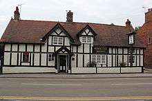
The Hawk Inn is on the main road through the village, and dates from the 17th century; it is a Grade II listed building.[19] The pub boasts carved woodwork both inside and out, including various carved faces and a number of engraved phrases on the exterior beams. The pub was once used for stabling horses and highwayman Dick Turpin supposedly once stayed there.[6]
Old House

Almost directly across from The Hawk Inn is a house, formerly two houses which have had the shared wall demolished in order to form a single dwelling, also dating from the 17th century. It too is a Grade II listed building. While the building is 17th century, the date 1510 is inscribed on a board over the door.[20]
Saint Matthew's Church
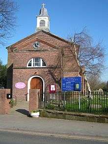
Saint Matthew's Church is a small Anglican church. It was built in two phases: the first phase which is the west part in 1810, and the second phase or east part in 1909.
The west part is a simple, brick built structure, with arched doorway and windows. It also has a small cupola on the nave's gable. The east part is in the Decorated style, designed by Reginald Longden, and has incorporated into it, a seven-light east window.
Community facilities
Haslington Cricket Club which runs four senior and six junior teams, is situated on the outskirts of the village. In 2014 the 1st XI made headlines worldwide after bowling Wirral CC out for just 3 runs, the lowest recorded total in any league cricket for over 100 years.
There is also a Christian Boys Brigade in the village; the company was founded in 1970 and operates from Haslington Methodist Church.
The village also contains two primary schools (The Dingle)[21] and Haslington Primary), the gutters croft pre-school, a village hall (The Yoxall Village Hall), St. Matthew's Church Hall and a community centre (The Gutterscroft Centre), a dentist, an NHS health centre, a chemist, a doctors surgery and four churches of various denominations. It also has The Millennium Rock, a commemorative stone which is situated on the village green.

The Croft Pre-School is an independent pre-school administered by a parents' committee. It opened in 1981 and operates in a single storey community centre building, sited within the village of Haslington.[22]
Notable people
Admiral Sir Francis Vernon, active during the time of the Spanish Armada, and who built Haslington Hall in 1545[23] and William Broome, poet and translator, born in Haslington on 3 May 1689.[24]
See also
References
- ↑ "2011 Census Haslington (Ward)". Office for National Statistics. Retrieved 2015-07-03.
- 1 2 "Origin of the name Haslington". Haslington.org. Retrieved 2011-10-14.
- 1 2 "Haslington Official Parish Handbook" (PDF). Haslington.org. Retrieved 2011-10-14.
- ↑ Dodgson (1970, p. 12)
- ↑ Haslington Parish Council (1982)
- 1 2 3 "A walk around Haslington" (PDF). Discover Cheshire. Retrieved 2011-10-13.
- ↑ Walking notes giving a source for name "Slaughter Hill", Cheshire County Council, archived from the original on 29 September 2007, retrieved 16 June 2007
- ↑ Youngs (1991, p. 20)
- ↑ Haslington parish council who's who, HaslingtonOnline (The Haslington parish council website), retrieved 18 March 2009
- ↑ Meetings, HaslingtonOnline (The Haslington parish council website), retrieved 18 March 2009
- 1 2 3 4 "Haslington Parish Plan 2010" (PDF). CheshireAction.org. Retrieved 2011-10-14.
- ↑ Cheshire (Structural Changes) Order 2008
- ↑ Cheshire County Council: Interactive Mapping: Crewe and Nantwich (accessed 27 January 2009)
- ↑ Profile: Edward Timpson, BBC News Online, 23 May 2008, retrieved 18 March 2009
- ↑ Alan Cassey (12 October 2008). "Flooded Mere". Haslington.org. Retrieved 2011-10-14.
- ↑ Matthew Taylor (2013-05-03). "7,000 new houses for Crewe outlined in Local Plan alternatives". Crewe Chronicle. Retrieved 2014-08-13.
- ↑ Haslington Parish Profile Population, statistics.gov.uk, retrieved 2015-11-06
- ↑ Haslington Parish Dwellings, statistics.gov.uk, retrieved 2015-11-06
- ↑ The Hawk Inn, ImagesofEngland.org.uk, retrieved 21 March 2009
- ↑ 126 and 124 High Street, ImagesofEngland.org.uk, retrieved 21 March 2009
- ↑ "Dingle Primary School: Welcome to our School". Dingle.cheshire.sch.uk. 2015-10-06. Retrieved 2016-01-13.
- ↑ "The Croft Preschool". Retrieved 30 January 2009.
- ↑ Discover Cheshire - Walking The Wildside
- ↑ William Broome biographical information. Encyclopaedia Britaninca Online. Retrieval Date: 16 April 2008.
Further reading
- Dodgson, J. McN. (1971), The place-names of Cheshire. Part three: The place-names of Nantwich Hundred and Eddisbury Hundred, Cambridge: Cambridge University Press, ISBN 0-521-08049-5
- Haslington Parish Council (1982), Haslington Official Parish Handbook, Haslington Parish Council
- Scholes, R. (2000), Towns and villages of Britain: Cheshire, Wilmslow, Cheshire: Sigma Press, ISBN 1-85058-637-3
- Youngs, F. A. (1991), Guide to the local administrative units of England. (Volume 1: Northern England), London: Royal Historical Society, ISBN 0-86193-127-0
External links
| Wikimedia Commons has media related to Haslington. |
- Haslington Cricket Club Website
- Haslington Circular Walk (Discovercheshire website)
- Haslington War Memorial, retrieved 8 December 2007
- 1st Haslington Boys' Brigade, retrieved 8 December 2007
- Haslington Methodist Church, retrieved 8 December 2007
Cheshire Portal | |
| Unitary authorities | |
| Major settlements | |
| Rivers | |
| Topics | |