Gundaroo
| Gundaroo New South Wales | |
|---|---|
 Main street of Gundaroo | |
|
Gundaroo | |
| Coordinates | 35°02′0″S 149°17′0″E / 35.03333°S 149.28333°ECoordinates: 35°02′0″S 149°17′0″E / 35.03333°S 149.28333°E |
| Population | 402 (2011 census)[1] |
| Established | 1830s |
| Postcode(s) | 2620 |
| Location | |
| LGA(s) | Yass Valley Council |
| State electorate(s) | Goulburn |
| Federal Division(s) | Eden-Monaro |
Gundaroo is a small village in the Southern Tablelands of New South Wales, Australia and in Yass Valley Council. It is situated to the east of the Yass River, about 16 kilometres (10 mi) north of Sutton, about 15 kilometres (9 mi) west of the Lake George range. At the 2011 census, Gundaroo had a population of 402,[1] up from 331 at the previous Census in 2006.[2]
The explorers Charles Throsby and Joseph Wild traveled through the Yass River valley in 1820. The Aborigines called the valley Candariro, meaning "blue crane". This name may have been the origin of Gundaroo,[3] or it may mean "big waterhole".[4] Governor Lachlan Macquarie granted the first white settler, Peter Cooney, 30 acres (12 ha) in 1825. Settlement proceeded fairly quickly and there were about 400 residents in the 1840s. The first non-residential building in Gundaroo was the Harrow Inn, built in 1834. A post office was built in 1848 and an Anglican church, St Luke's in Upper Gundaroo (now part of a pottery business), in 1849. The first school opened in 1850 and a Police Station in 1852.[5] A major impetus for the growth in the middle of the nineteenth century was the discovery of gold in the district in 1852.[6]
World War II air crash
On 7 December 1943, a RAAF Lockheed Ventura crashed three miles south-east of Gundaroo, killing all five crew members.[7] A memorial to the victims was erected in the town.[8]
Gallery
 St Mark's Anglican Church in Cork St, formerly Gundaroo Court House, built in 1875
 The Royal Hotel Gundaroo
 Gundaroo Community Church was originally the Presbyterian Church (1864). It is now under a Uniting Church.
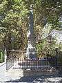 Gundaroo War Memorial
References
- 1 2 Australian Bureau of Statistics (31 October 2012). "Gundaroo (Urban Centres and Localities)". 2011 Census QuickStats. Retrieved 24 February 2015.
- ↑ Australian Bureau of Statistics (25 October 2007). "Gundaroo (L) (Urban Centre/Locality)". 2006 Census QuickStats. Retrieved 2009-09-15.
- ↑ Exploring the ACT and Southeast New South Wales, J. Kay McDonald, Kangaroo Press, Sydney, 1985 ISBN 0-86417-049-1
- ↑ "Gundaroo (village)". Geographical Names Register (GNR) of NSW. Geographical Names Board of New South Wales. Retrieved 25 February 2015.
- ↑ "Gundaroo". The Southern Tablelands of NSW. Retrieved 13 July 2007.
- ↑ Canberra's Engineering Heritage, William Charles Andrews, Institution of Engineers, Canberra, 1990, p. 5
- ↑ Dunn, Peter. "CRASH OF A VENTURA 3 MILES SOUTH EAST OF GUNDAROO, ACT ON 7 DECEMBER 1943". www.ozatwar.com. Retrieved 22 December 2012.
- ↑ Southwell-Keely, Michael. "Gundaroo Air Disaster Memorial". War Memorials in Australia. Retrieved 22 December 2012.
External links
![]() Media related to Gundaroo at Wikimedia Commons
Media related to Gundaroo at Wikimedia Commons