Gros Cap Archaeological District
|
Gros Cap Archaeological District | |
|
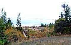
Part of site at West Moran Bay and mouth of stream. | |
  | |
| Location | West Moran Bay, Southeast of Gros Cap on US 2[1] |
|---|---|
| Nearest city | Gros Cap, Michigan |
| Coordinates | 45°52′0″N 84°48′0″W / 45.86667°N 84.80000°WCoordinates: 45°52′0″N 84°48′0″W / 45.86667°N 84.80000°W |
| Area | 13.5 acres (5.5 ha) |
| NRHP Reference # | 82000540[2] |
| Added to NRHP | October 29, 1982 |
The Gros Cap Archaeological District is a set of three archaeological sites located in Moran Township, Michigan, USA, designated 20MK6, 20MK7 and 20MK111.[3] It was listed on the National Register of Historic Places in 1982.[2] The three sites cover 13.5 acres (5.5 ha) and include a village site and portions of the Gros Cap Cemetery.[2]
History
The site is associated with the Odawa people,[4] who settled in the area around West Moran Bay in the late 17th century.[5] The Odawa village, located on the shore of the bay,[6] had at one time 1500 people living in it,[7] and was connected via a trail to the village to the east where St. Ignace is now located.[8] A cemetery (now known as the Gros Cap Cemetery and still in use) was originally adjacent to the tribal village[5] and was used as their burial ground.[9] As more European settlers moved into the area, the Ottawa population decreased due to further emigration or intermarriage with the arriving settlers. However, the cemetery continued to be used by French, English and, eventually, American settlers.[9]
References
- ↑ The NRIS gives the location of the Gros Cap Archaeological District as "Address Restricted". However, multiple sources specify that the Odawa village was on West Moran Bay, and contiguous with the Gros Cap Cemetery. Geocoordinates given are approximate.
- 1 2 3 National Park Service (2010-07-09). "National Register Information System". National Register of Historic Places. National Park Service.
- ↑ T. J. Martin (1981), "Animal Remains from the Gros Cap Site: An Evaluation of Fish Scales Versus Fish Bones to Assess the Species Composition of an Archaeological Assemblage", Michigan Archaeologist, 27 (3-4): 77–86
- ↑ "MICHIGAN - Dickinson County (NRIS database access)". NationalRegisterOHhistoricPlaces.com. Retrieved May 20, 2012.
- 1 2 United States Office of Archeology and Historic Preservation (1973), The National register of historic places, 1972, Volume 1, U.S. Govt. Print. Off., p. 223
- ↑ John Read Bailey (1897), Mackinac: formerly Michilimackinac (3 ed.), p. 54
- ↑ Dwight H. Kelton (1893), Annals of Fort Mackinac, Detroit Free Press printing Company, p. 127
- ↑ Mrs. Emerson (Margaret) Smith (1961). "Gros Cap or Western Cemetery". MI Gen Web.
- 1 2 "Gros Cap Cemetery". Michigan State Housing Development Authority: Historic Sites Online. Retrieved May 21, 2012.
Further reading
- T. J. Martin (1981), "Animal Remains from the Gros Cap Site: An Evaluation of Fish Scales Versus Fish Bones to Assess the Species Composition of an Archaeological Assemblage", Michigan Archaeologist, 27 (3-4): 77–86
- Susan R. Martin (1979), An Archaeological Site Examination of the Gros Cap Cemetery Area, Mackinac County, Michigan — Phase II, Michigan Technological University
- George Irving Quimby (1966), Indian Culture And European Trade Goods: The Archaeology Of The Historic Period In The Western Great Lakes Region, Univ of Wisconsin Press, pp. 125–134, ISBN 0299040747
- Craig F. Nerm; Charles E. Cleland (March 1974), "The Gros Cap Cemetery Site, St. Ignace, Michigan: A Reconsideration of the Greenlees Collection", Michigan Archaeologist, 20: 1–58
- George Quimby (December 1963), "The Gros Cap Cemetery Site in Mackinac County, Michigan", Michigan Archaeologist, 9: 50–57
| Topics | |
|---|---|
| Lists by states |
|
| Lists by insular areas | |
| Lists by associated states | |
| Other areas | |
| |