Grange, South Australia
| Grange Adelaide, South Australia | |||||||||||||
|---|---|---|---|---|---|---|---|---|---|---|---|---|---|
 Grange Jetty | |||||||||||||
| Population | 5,857 (2011 census)[1] | ||||||||||||
| • Density | 2,550/km2 (6,600/sq mi) | ||||||||||||
| Established | 1878 | ||||||||||||
| Postcode(s) | 5022[2] | ||||||||||||
| Area | 2.3 km2 (0.9 sq mi) | ||||||||||||
| Location | 11 km (7 mi) W of Adelaide city centre[2] | ||||||||||||
| LGA(s) | City of Charles Sturt[3] | ||||||||||||
| State electorate(s) | Colton (2011)[4] | ||||||||||||
| Federal Division(s) | Hindmarsh (2011)[5] | ||||||||||||
| |||||||||||||


Grange is a coastal suburb of Adelaide, South Australia, located 11 kilometres from the Adelaide city centre. It is located in the City of Charles Sturt.
History
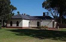
Originally called The Grange, the suburb is named after Captain Charles Sturt's cottage,[6] which originally stood on 500 acres (200 ha) of farmland. Sturt's farm was subdivided in 1878 by a private company intending to establish a beach resort.[7] The cottage still stands and is now a museum.
Geography
Grange is a beachside suburb lying just north of Henley Beach. The main land boundaries are Trimmer Parade, Frederick Road and Grange Road.[8]
Demographics
The 2006 Census by the Australian Bureau of Statistics counted 5,238 persons in Grange on census night. Of these, 47.1% were male and 52.9% were female.[9]
The majority of residents (77.1%) are of Australian birth, with an additional 5.9% naming England as their country of birth.[9]
The age distribution of Grange residents is skewed slightly higher than the greater Australian population. 72% of residents were over 25 years in 2006, compared to the Australian average of 66.5%; and 28% were younger than 25 years, compared to the Australian average of 33.5%.[9]
Politics
Local government
Grange is part of Grange Ward in the City of Charles Sturt local government area, being represented in that council by Tom Scheffler and Rachel Tullio.[3]
State and federal
Grange lies in the state electoral district of Colton[4] and the federal electoral division of Hindmarsh.[5] The suburb is represented in the South Australian House of Assembly by Paul Caica[4] and federally by Matt Williams.[5][10]
Community
The local newspaper is the Weekly Times Messenger. Other regional and national newspapers such as The Advertiser and The Australian are also available.[11]
Community groups
A community centre is located on Charles Sturt Avenue.[8]
Schools
Grange Primary School is located on Jetty Street.[12]
Facilities and attractions
Grange Jetty, built in 1879,[13] lies midway along Grange Beach.[8]
Shopping and dining
The Grange Hotel, located on the esplanade at Grange Beach, was originally licensed in 1881.[14]
Parks
In addition to Grange Beach, the suburb has several parks and reserves. Grange Recreation Reserve is located in the northwest of the suburb and offers a playing field and playground. Playgrounds are also located in Lines Reserve, on Lines Street, and Kirkcaldy Park, on Kirkcaldy Avenue.[8] The greenspace in the centre of the suburb is notable as being the location of Charles Sturt's still-extant cottage.[8]
Transportation
Roads
Grange is serviced by Grange Road, connecting the suburb to Adelaide city centre. Seaview Road and Military Road link Grange to several of Adelaide's other coastal suburbs. Frederick Road, on the suburb's eastern boundary, connects the suburb with the shopping and entertainment facilities in West Lakes.[8]
Public transport
Grange is serviced by public transport run by the Adelaide Metro.[15]
See also
| Wikimedia Commons has media related to Grange, South Australia. |
References
- ↑ Australian Bureau of Statistics (31 October 2012). "Grange (State Suburb)". 2011 Census QuickStats. Retrieved 5 October 2016.
- 1 2 "Grange, South Australia (Adelaide)". Postcodes-Australia. Postcodes-Australia.com. Retrieved 29 September 2011.
- 1 2 "City of Charles Sturt Wards and Council Members". City of Charles Sturt. Retrieved 29 March 2016.
- 1 2 3 "Electoral Districts - Electoral District for the 2010 Election". Electoral Commission SA. Retrieved 29 September 2011.
- 1 2 3 "Find my electorate: Hindmarsh". Australian Electoral Commission. Retrieved 29 September 2011.
- ↑ "Place Names of South Australia". The Manning Index of South Australian History. State Library of South Australia. Retrieved 16 April 2011.
- ↑ "Adelaide and Environs ADELAIDE'S BEACHES". South Australia Travel Guide. Retrieved 4 November 2015.
- 1 2 3 4 5 6 Adelaide and surrounds street directory (47th ed.). UBD. 2009. ISBN 978-0-7319-2336-6.
- 1 2 3 Australian Bureau of Statistics (25 October 2007). "Grange (State Suburb)". 2006 Census QuickStats. Retrieved 29 September 2011.
- ↑ http://www.aph.gov.au/Senators_and_Members/Parliamentarian_Search_Results?expand=1&q=williams&mem=1&par=-1&gen=0&ps=12
- ↑ "South Australian Newspapers". Newspapers.com.au. Australia G'day. Retrieved 29 September 2011.
- ↑ "Australian Schools Directory". Australian Schools Directory. Retrieved 29 September 2011.
- ↑ "Local History Factsheet: A brief history of the suburb Grange" (PDF). City of Charles Sturt. Retrieved 4 November 2015.
- ↑ "History". The Grange Hotel official website. Grange Hotel. Retrieved 16 April 2011.
- ↑ "Public Transport in Adelaide". Adelaide Metro official website. Dept. for Transport, Energy and Infrastructure, Public Transport Division. 12 January 2011. Retrieved 29 September 2011.
External links
- "City of Charles Sturt". Official website. City of Charles Sturt. Retrieved 29 September 2011.
Coordinates: 34°54′00″S 138°29′20″E / 34.900°S 138.489°E