Gosport, Indiana
| Gosport, Indiana | |
|---|---|
| Town | |
|
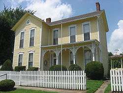
The H.G. Osgood House, a historic site in the town | |
 Location in the state of Indiana | |
| Coordinates: 39°20′59″N 86°39′56″W / 39.34972°N 86.66556°WCoordinates: 39°20′59″N 86°39′56″W / 39.34972°N 86.66556°W | |
| Country | United States |
| State | Indiana |
| County | Owen |
| Township | Wayne |
| Area[1] | |
| • Total | 0.39 sq mi (1.01 km2) |
| • Land | 0.39 sq mi (1.01 km2) |
| • Water | 0 sq mi (0 km2) |
| Elevation | 696 ft (212 m) |
| Population (2010)[2] | |
| • Total | 826 |
| • Estimate (2012[3]) | 820 |
| • Density | 2,117.9/sq mi (817.7/km2) |
| Time zone | EST (UTC-5) |
| • Summer (DST) | EST (UTC-5) |
| ZIP code | 47433 |
| Area code(s) | 812 |
| FIPS code | 18-28440[4] |
| GNIS feature ID | 0435238[5] |
Gosport is a town in Wayne Township, Owen County, Indiana, United States. The population was 826 at the 2010 census. It is part of the Bloomington, Indiana Metropolitan Statistical Area.
History
Gosport was platted in 1829, and named for Ephraim Goss, an early settler.[6]
The Gosport Historic District and Dr. H.G. Osgood House are listed on the National Register of Historic Places.[7][8]
Geography
According to the 2010 census, Gosport has a total area of 0.39 square miles (1.01 km2), all land.[1]
Demographics
| Historical population | |||
|---|---|---|---|
| Census | Pop. | %± | |
| 1850 | 548 | — | |
| 1870 | 860 | — | |
| 1880 | 740 | −14.0% | |
| 1890 | 720 | −2.7% | |
| 1900 | 726 | 0.8% | |
| 1910 | 776 | 6.9% | |
| 1920 | 700 | −9.8% | |
| 1930 | 722 | 3.1% | |
| 1940 | 729 | 1.0% | |
| 1950 | 672 | −7.8% | |
| 1960 | 646 | −3.9% | |
| 1970 | 692 | 7.1% | |
| 1980 | 729 | 5.3% | |
| 1990 | 764 | 4.8% | |
| 2000 | 715 | −6.4% | |
| 2010 | 826 | 15.5% | |
| Est. 2015 | 803 | [9] | −2.8% |
2010 census
As of the census[2] of 2010, there were 826 people, 325 households, and 202 families residing in the town. The population density was 2,117.9 inhabitants per square mile (817.7/km2). There were 380 housing units at an average density of 974.4 per square mile (376.2/km2). The racial makeup of the town was 98.5% White, 0.7% African American, 0.1% Asian, and 0.6% from two or more races. Hispanic or Latino of any race were 1.0% of the population.
There were 325 households of which 35.1% had children under the age of 18 living with them, 43.1% were married couples living together, 12.3% had a female householder with no husband present, 6.8% had a male householder with no wife present, and 37.8% were non-families. 32.9% of all households were made up of individuals and 13.5% had someone living alone who was 65 years of age or older. The average household size was 2.42 and the average family size was 3.00.
The median age in the town was 38.2 years. 25.8% of residents were under the age of 18; 8.7% were between the ages of 18 and 24; 24.9% were from 25 to 44; 23.8% were from 45 to 64; and 16.8% were 65 years of age or older. The gender makeup of the town was 46.0% male and 54.0% female.
2000 census
As of the census[4] of 2000, there were 715 people, 273 households, and 190 families residing in the town. The population density was 1,868.6 people per square mile (726.5/km²). There were 301 housing units at an average density of 786.7 per square mile (305.8/km²). The racial makeup of the town was 98.60% White, 0.42% African American, 0.42% Native American, 0.14% Asian, and 0.42% from two or more races. Hispanic or Latino of any race were 2.24% of the population.
There were 273 households out of which 34.8% had children under the age of 18 living with them, 52.7% were married couples living together, 12.1% had a female householder with no husband present, and 30.4% were non-families. 27.1% of all households were made up of individuals and 16.1% had someone living alone who was 65 years of age or older. The average household size was 2.44 and the average family size was 2.94.
In the town the population was spread out with 26.9% under the age of 18, 5.2% from 18 to 24, 27.3% from 25 to 44, 20.8% from 45 to 64, and 19.9% who were 65 years of age or older. The median age was 38 years. For every 100 females there were 84.8 males. For every 100 females age 18 and over, there were 80.3 males.
The median income for a household in the town was $31,833, and the median income for a family was $34,545. Males had a median income of $32,396 versus $18,667 for females. The per capita income for the town was $14,101. About 14.4% of families and 17.2% of the population were below the poverty line, including 30.4% of those under age 18 and 4.4% of those age 65 or over.
Notable People
Military

- U.S. Army Colonel Benjamin F. Hays was born on 4 September 1826 in Greene County, Tennessee. He served as a Second Lieutenant in B Company, 4th Indiana Infantry during the Mexican War.[11] During the Civil War, he served in the 1st Indiana Heavy Artillery, promoted to colonel on 8 February 1865.[12] He fought in the Battle of Baton Rouge and the Battle of Mobile Bay. Following the war, he commanded the District of South Alabama, until he was mustered out on 10 January 1866.[11] Then, he served in the Indiana House of Representatives in 1867. He resided in Gosport as a merchant until he died on 14 January 1872, and was buried in the Gosport Cemetery.[11][13]
- U.S. Army Colonel James Ellis Burton was born on 23 September 1824 to John and Nancy Agnes (née Wishard) Burton in Mount Tabor, Indiana. He was married to Cynthia Ann (née Van Buskirk), and they had one son, John Morgan, on 7 January 1852, who died on 13 February 1856.[14] He was promoted to colonel on 4 May 1865 and mustered out on 21 July 1865.[15] Colonel Burton fought in the Atlanta Campaign, the Savannah Campaign, and the Carolinas Campaign. He was a merchant before the war and a farmer in Gosport afterwards.[16] He died on 28 September 1900, and is buried in Liberty Church Cemetery, near Mount Tabor.[14]
Other
- Child actress Patsy Doris Dittemore was born in Gosport on March 20, 1934, to James and Gladys Elizabeth (May) Dittemore. Her mother died 19 days after her birth; and, she was sent to California to live with her maternal grandparents, taking their last name and being called "Patsy May." She played the baby sister of Spanky in the Our Gang series of short-subject comedies from 1935 to 1937, appearing for the first time in Little Papa and the last time in Our Gang Follies of 1938. At age 11, her final film appearance was in an uncredited role in the Great Stagecoach Robbery (1945). She died on January 1, 2013, and is buried in the Gosport Cemetery.[17][18]
- Former Owen County auditor and current Gosport resident, Angela M. Lawson, was indicted on February 13, 2015, for using $310,000 in taxpayer money to pay for personal expenses, including food, alcohol, gift cards, toys, jewelry and vacations from 2010 to 2014, and faces up to 50 years in prison. Further, the Indiana Attorney General filed a lawsuit against her demanding that she repay more than $386,000 of embezzled taxpayer funds and nearly $100,000 in investigative costs.[19][20] She was the county’s auditor from 2005 to 2012 and a deputy auditor from 2013 to 2014.[21][22] On January 5, 2015, the county filed a civil lawsuit against her and her husband, Larry Lawson, for almost $1.2 million in damages from this embezzlement of county taxpayer money.[23][24]
- Former office manager for the City of Bloomington Parks and Recreation Departmentand current Gosport resident, Judith A. Seigle, was indicted on March 13, 2015 by a federal grand jury on a wire fraud charge alleging that she executed a scheme to steal over $400,000.[25] Evidence showed purchases included a vehicle, clothes, meals and payments on her personal credit card.[26] She faces up to 20 years in prison if convicted.
- Eugene M. Stoner, inventor of the M16 rifle, was born in Gosport, IN on November 22, 1922 to Lloyd and Britannia Stoner.[27] He moved to California as a child and graduated from Long Beach Polytechnical High School. He later joined the U.S. Marines as an armorer and fought in the South Pacific during World War II, honorably discharged as a Corporal.[28] He held some 100 patents on his inventions, and was a co-founder of Ares Incorporated, a weapons research and development company based in Port Clinton, Ohio. He died on April 24, 1997 in Palm City, Florida and buried in the Quantico National Cemetery in Virginia.[29]
References
- 1 2 "G001 - Geographic Identifiers - 2010 Census Summary File 1". United States Census Bureau. Retrieved 2015-07-16.
- 1 2 "American FactFinder". United States Census Bureau. Retrieved 2012-12-11.
- ↑ "Population Estimates". United States Census Bureau. Retrieved 2013-06-25.
- 1 2 "American FactFinder". United States Census Bureau. Retrieved 2008-01-31.
- ↑ "US Board on Geographic Names". United States Geological Survey. 2007-10-25. Retrieved 2008-01-31.
- ↑ Blanchard, Charles (1884). Counties of Clay and Owen, Indiana: Historical and Biographical. F.A. Battey & Company. p. 712.
- ↑ National Park Service (2010-07-09). "National Register Information System". National Register of Historic Places. National Park Service.
- ↑ "National Register of Historic Places Listings". Weekly List of Actions Taken on Properties: 6/24/13 through 6/28/13. National Park Service. 2013-07-05.
- ↑ "Annual Estimates of the Resident Population for Incorporated Places: April 1, 2010 to July 1, 2015". Retrieved July 2, 2016.
- ↑ "Census of Population and Housing". Census.gov. Retrieved June 4, 2015.
- 1 2 3 Hunt, Roger (2014), Colonels in Blue--Indiana, Kentucky and Tennessee: A Civil War Biographical Dictionary, Jefferson, NC: McFarland & Company, pp. 60–61
- ↑ Roger (1865), Report of the Adjutant General of the State of Indiana, Volume II - 1861-1865, Indianapolis, IN: W.R. Holloway, p. 199
- ↑ Find A Grave. "Col Benjamin F Hays". Retrieved 11 June 2015.
- 1 2 Find A Grave. "Col James Ellis Burton". Retrieved 11 June 2015.
- ↑ Roger (1865), Report of the Adjutant General of the State of Indiana, Volume II - 1861-1865, Indianapolis, IN: W.R. Holloway, p. 323
- ↑ Hunt, Roger (2014), Colonels in Blue--Indiana, Kentucky and Tennessee: A Civil War Biographical Dictionary, Jefferson, NC: McFarland & Company, p. 33
- ↑ Lentz III, Harris M. (2014), Obituaries in the Performing Arts, 2013, (Jefferson, N.C.: McFarland & Company), p. 290.
- ↑ "Patsy May". Internet Movie Database. Retrieved 11 February 2015.
- ↑ staff (17 February 2015). "Attorney General Files Suit Against Former Owen County Auditor To Recover $486,000". Spencer Evening World. pp. 1, 5. Retrieved 17 February 2015.
- ↑ Zoeller, Greg (16 February 2015). "AG files suit against former Owen County Auditor to recover $486K". Office of the Indiana Attorney General. Retrieved 17 February 2015.
- ↑ McCall, Alexander (13 February 2015). "Former Owen County Auditor Indicted For Stealing $300,000". WFIU/WTIU News. Retrieved 14 February 2015.
- ↑ Szink, John (14 February 2015). "Former Owen County Auditor Indicted On Theft Charges". WWBL News. Retrieved 14 February 2015.
- ↑ Stanley, Michael (13 January 2015). "County Files Civil Lawsuit Against Lawsons; Pretrial Hearing Is Today". Spencer Evening World. p. 1. Retrieved 14 February 2015.
- ↑ staff (26 January 2015). "Former Owen Co. Auditor Facing $1.18 Million Lawsuit". WBIW News. Retrieved 14 February 2015.
- ↑ U.S. Attorney's Office (13 March 2015). "Former Bloomington Parks Department Office Manager Indicted for Fraud". Retrieved 18 March 2015.
- ↑ Stanley, Michael (18 March 2015). "Gosport Woman Indicted For Theft From Bloomington Parks". Spencer Evening World. pp. 1, 5. Retrieved 18 March 2015.
- ↑ Noble, Holcomb B. (27 April 1997). "Eugene Stoner, 74, Designer Of M-16 Rifle and Other Arms". The New York Times. Retrieved 18 March 2015.
- ↑ Ezell, Virginia (30 May 1997). "Obituary: Eugene Stoner". The Independent. Retrieved 18 March 2015.
- ↑ Find A Grave. "Eugene Morrison Stoner". Retrieved 18 March 2015.
Municipalities and communities of Owen County, Indiana, United States | ||
|---|---|---|
| Towns | ||
| Townships | ||
| Unincorporated communities | ||