Golden Pond, Kentucky
| Golden Pond | |
|---|---|
| Ghost town | |
 Golden Pond | |
| Coordinates: 36°47′08″N 88°01′27″W / 36.78556°N 88.02417°WCoordinates: 36°47′08″N 88°01′27″W / 36.78556°N 88.02417°W | |
| Country | United States |
| State | Kentucky |
| County | Trigg |
| Elevation | 407 ft (124 m) |
| Time zone | Central (CST) (UTC-6) |
| • Summer (DST) | CDT (UTC-5) |
| GNIS feature ID | 508108[1] |
Golden Pond is a ghost town in western Trigg County, Kentucky, United States. The town is located in the Land Between the Lakes National Recreation Area 11 miles (18 km) west-southwest of Cadiz. Golden Pond was established in the 19th century and became known for its moonshining activity during Prohibition. The settlement was abandoned in 1969 when the land in the recreation area was evacuated.
Etymology
Golden Pond shares its name with a pond located at 36°46′45″N 88°03′48″W / 36.77917°N 88.06333°W, 2.25 miles (3.62 km) west of the town.[2] The most accepted story of the name's origin states that it arose when sunshine on the pond caused it to resemble melted gold. Another story, likely to be legend, states that the community was named for a man who placed gold dust in the vicinity of the pond in an attempt to trigger a gold rush and subsequent property boom. The community was allegedly also named Fungo for the entertainment at the local saloon. This name may have referred to a community further west which later merged with Golden Pond, and may not have been used at all.[3][4]
Geography
Golden Pond is located at 36°47′08″N 88°01′27″W / 36.78556°N 88.02417°W,[1] in western Kentucky near the Tennessee border. It is situated in Land Between the Lakes National Recreation Area, a peninsula lying between Kentucky Lake and Lake Barkley, which are formed by the Tennessee River and Cumberland River respectively; the town lies 2.5 miles (4.0 km) west of the latter lake. The two lakes isolate the peninsula from the rest of Kentucky, as the region can only be accessed via Tennessee or by crossing the lakes. U.S. Route 68 and Kentucky Route 80 pass through the community concurrently, providing access to Marshall County to the west and the remainder of Trigg County to the east; during its existence, the community ran for almost 1 mile (1.6 km) along this highway. Another road, known as The Trace, runs west of Golden Pond and connects the peninsula to Livingston County to the north and Stewart County to the south.[5] Golden Pond is 11 miles (18 km) west-southwest of Cadiz, the county seat of Trigg County.[3] The area is served by the Cadiz post office; the name Golden Pond is still accepted by the U.S. Postal Service and is used in the recreation area's mailing address.[6][7]
History
The name Golden Pond was first applied to a post office in the area on December 28, 1848; the location of the post office is unknown, though it may have been near the pond of the same name.[3] The town at the recognized location was established in 1882. The early town's economy was based on the area's natural resources, which included timber, iron ore, and fertile soil for agriculture. In 1898, a fire destroyed Golden Pond, which was subsequently rebuilt; a second conflagration burned the town in 1936, though it again recovered.[4] During Prohibition, Golden Pond earned a national reputation for distilling moonshine whiskey, which was later sold in speakeasies in Midwestern cities such as Chicago, Detroit, and St. Louis.[8] In 1964, the Tennessee Valley Authority opened the first office for the Land Between the Lakes National Recreation Area at Golden Pond. The land within the recreation area was subsequently evacuated; Golden Pond was abandoned by 1969, and the last residents left the peninsula in 1970.[4][8] Many of the residents moved to a location in Calloway County which was named Little Golden Pond in 1989.[9]
References
- 1 2 "Golden Pond". Geographic Names Information System. United States Geological Survey.
- ↑ "Golden Pond". Geographic Names Information System. United States Geological Survey.
- 1 2 3 Rennick, Robert M. (1988). Place Names of Kentucky. University Press of Kentucky. p. 400.
- 1 2 3 Hay, Melba Porter; Dianne Wells; Thomas H. Appleton (2002). Roadside History: A Guide to Kentucky Highway Markers. University Press of Kentucky. p. 327.
- ↑ Kentucky Official Highway Map (PDF) (Map). Kentucky Transportation Cabinet. 2011. Retrieved June 17, 2011.
- ↑ United States Postal Service (2012). "USPS - Look Up a ZIP Code". Retrieved 2012-02-15.
- ↑ "Contact Us". Land Between the Lakes National Recreation Area. Retrieved June 17, 2011.
- 1 2 Kleber, John E. (1992). The Kentucky Encyclopedia. University Press of Kentucky. p. 1045.
- ↑ "Ex-Golden Pond Residents Succeed in Creating Settlement from Sentiment". Lexington Herald-Leader. June 20, 1989.
Municipalities and communities of Trigg County, Kentucky, United States | ||
|---|---|---|
| City | 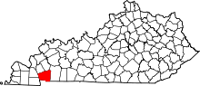 | |
| CDP | ||
| Other unincorporated community | ||
| Ghost town | ||
| Footnotes | ‡This populated place also has portions in an adjacent county or counties | |