Gilmanton Ironworks, New Hampshire
| Gilmanton Ironworks, New Hampshire | |
|---|---|
| Unincorporated community | |
 Gilmanton Ironworks  Gilmanton Ironworks | |
| Coordinates: 43°25′04″N 71°17′45″W / 43.41778°N 71.29583°WCoordinates: 43°25′04″N 71°17′45″W / 43.41778°N 71.29583°W | |
| Country | United States |
| State | New Hampshire |
| County | Belknap |
| Town | Gilmanton |
| Elevation | 614 ft (187 m) |
| Time zone | Eastern (EST) (UTC-5) |
| • Summer (DST) | EDT (UTC-4) |
| ZIP code | 03837 |
| Area code(s) | 603 |
| GNIS feature ID | 867073[1] |
Gilmanton Ironworks (alternately Gilmanton Iron Works) is an unincorporated community in the town of Gilmanton in Belknap County, New Hampshire, in the United States. It is located near the eastern boundary of the town, along a stretch of the Suncook River south of the outlet of Crystal Lake. New Hampshire Route 140 runs through the village, leading east to Alton and west to the center of Gilmanton and then Belmont.
Gilmanton Ironworks has a separate ZIP code (03837) from the rest of the town of Gilmanton.
Sites of interest
References
Municipalities and communities of Belknap County, New Hampshire, United States | ||
|---|---|---|
| City | 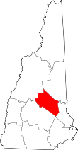 | |
| Towns | ||
| CDPs | ||
| Other villages | ||
| Footnotes | ‡This populated place also has portions in an adjacent county or counties | |
This article is issued from Wikipedia - version of the 7/10/2016. The text is available under the Creative Commons Attribution/Share Alike but additional terms may apply for the media files.