Gerrans
| Gerrans | |
| Cornish: Gerens | |
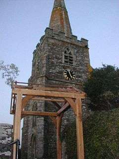 Gerrans Parish Church |
|
 Gerrans |
|
| Population | 867 (Civil Parish, 2011) |
|---|---|
| OS grid reference | SW873352 |
| Civil parish | Gerrans |
| Unitary authority | Cornwall |
| Ceremonial county | Cornwall |
| Region | South West |
| Country | England |
| Sovereign state | United Kingdom |
| Post town | TRURO |
| Postcode district | TR2 |
| Dialling code | 01872 |
| Police | Devon and Cornwall |
| Fire | Cornwall |
| Ambulance | South Western |
| EU Parliament | South West England |
| UK Parliament | Truro and Falmouth |
Coordinates: 50°10′41″N 4°58′52″W / 50.178°N 4.981°W
Gerrans (Cornish: Gerens) is a coastal civil parish and village on the Roseland Peninsula in Cornwall, England, United Kingdom. The village adjoins Portscatho (the villages have almost merged into one but retain their identities) on the east side of the peninsula. The village is situated approximately seven miles (11 km) south-southeast of Truro.[1]
The name Gerrans derives from Gerent, an 8th-century Cornish saint.[2] The parish runs north-south along the eastern side of the Roseland peninsula. It is bounded to the south and east by the sea, to the west by St Just in Roseland parish, and to the north by Philleigh parish.[3] The population was 933 in the 2001 census,[2] reducing to 867 at the 2011 census.[4] Trewithian is the only settlement of any size in the parish apart from Gerrans and Portscatho.
Gerrans lies within the Cornwall Area of Outstanding Natural Beauty (AONB). Almost a third of Cornwall has AONB designation, with the same status and protection as a National Park.
History and landmarks

Gerrans parish church (dedicated to St Gerent or Gerendus) was built in the 13th century and enlarged in the 15th century when the south and aisle and the tower topped with a spire were added. However, in 1849 everything except the tower was rebuilt (by William White of Truro) though this was done as closely as possible to the original church. The two-stage tower is buttressed, battlemented, and topped by a spire.[2]
The manor of Tregear belonged to the Bishops of Exeter in mediaeval times and Gerent may have had a castle (Dingerein or Dinurrin) here.[5][6] At the time of Domesday Book (1086) the manor was recorded as having 12 hides of land and land for 60 ploughs. The lord (the Bishop of Exeter) held half a hide of land with 2 ploughs and 6 serfs, and 18 villeins and 12 smallholders had the rest of the land with 16 ploughs. There was a quarter of a square league of pasture and half a square league of woodland. Though the value had formerly been only £5 sterling the manor was then worth £8.[7] The manor of Tregear (or Tregaire) was one of the Cornish manors of the Bishops of Exeter; it covered much of the Roseland peninsula.[8]
A small museum, the Gerrans Parish Heritage Centre, is located in the village.
References

- ↑ Ordnance Survey: Landranger map sheet 204 Truro & Falmouth ISBN 978-0-319-23149-4
- 1 2 3 GENUKI website: Gerrans. retrieved May 2010
- ↑ Cornwall Council online mapping. Retrieved May 2010
- ↑ "Parish population 2011 census.Retrieved 9 Feb 2015".
- ↑ Cornish Church Guide (1925) Truro: Blackford; pp. 100-01
- ↑ The Ecclesiologist; Oct. 1849, p. 246
- ↑ Thorn, C. et al., ed. (1979) Cornwall. Chichester: Phillimore; entry 2,3
- ↑ Orme, Nicholas (2007) Cornwall and the Cross: Christianity, 500–1560. Chichester: Phillimore in association with the Institute of Historical Research at the University of London ISBN 1-86077-468-7; pp. 11, 29
Further reading
- Doble, G. H. (1964). The Saints of Cornwall, part 3; Saint Gerent, patron of Gerrans. Truro: Dean and Chapter; pp. 74–88
External links
![]() Media related to Gerrans at Wikimedia Commons
Media related to Gerrans at Wikimedia Commons
Cornwall Portal | |
| Unitary authorities | |
| Major settlements |
|
| Rivers | |
| Topics | |
Civil parishes of Truro and Falmouth constituency | ||
|---|---|---|
Cornwall Portal | ||