Kinneret (archaeological site)
Coordinates: 32°51′38″N 35°30′26″E / 32.86056°N 35.50722°E
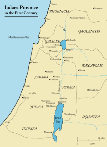
Kinneret (Hebrew: כִּנֶּרֶת) is the name of an important Bronze and Iron Age city situated on the northwestern shore of the Sea of Galilee, mentioned in the Old Testament and in the Aqhat Epic of Ugarit. Older Bible translations name Kinneret alternatively Kinnereth or Chinnereth, and sometimes in the plural as Chinneroth.[1] The name evolved in time to become Gennesaret and Ginosar (Hebrew: גִּנֵּיסַר). The remains of Kinneret have been excavated at a site called Tell el-'Oreimeh in Arabic and Tel Kinrot in Modern Hebrew.
Due to its prominence, the city gave its name to the lake for long periods of history, as the Sea of Kinneret, Kinnerot, Gennesaret or Ginosar, the last two mirroring the transformation of the name. "Gennesaret" is the Grecized form of Kinneret.[2] As other places around the lake rose to prominence, such as Tiberias and Qasr al-Minya, the name of the lake changed to Lake Tiberias or Lake Minya.
The name is also used for the "Plain of Gennesaret", which stretches south of the ancient city. For beauty and fertility this is called "the Paradise of Galilee". Its modern names are Plain of Ginosar (translated from modern Hebrew) and el-Ghuweir in Arabic.
The present-day Israeli Kibbutz Ginosar derives its name from the ancient town, though it is not located on its precise site. Even more remote, on the southeastern shore of the lake, are the two settlements of Moshavat Kinneret and Kvutzat Kinneret.
Identification and location
The site of the fortified Bronze and Iron Age city of Kinneret is at the mound known in Arabic as Tell el-'Oreimeh and in modern Hebrew as Tel Kinrot, halfway between Capernaum and Magdala.[3][4] Situated on an important trade route, its elevated position meant that it also overlooked and guarded the Plain of Ginosar from its northern end.
The tell is being excavated as part of a large archaeological project which is ongoing since 2002.[5] It has the ICS Coordinates: 200805-1252830;[6][7][8] ca. 32.87000 N, 35.539312 E.[8]
In the Bible
Kinneret was a town allotted to the tribe of Naphtali (Joshua 19:35). The name appears in the singular form as "Kinneret" (Numbers 34:11, Deuteronomy 3:17) or in the plural as "Kinneroth" (Joshua 11:2, 12:3). In the New Testament the name appears changed to Gennesaret (Luke 5:1).
This city or area is also a place where Jesus visited and performed healing.[9] To quote from the Douay-Rheims Bible, which uses the form "Genesar" (see Gospel of Matthew),
- [34] And having passed the water, they came into the country of Genesar.
- [35] And when the men of that place had knowledge of him, they sent into all that country, and brought to him all that were diseased.
- [36] And they besought him that they might touch but the hem of his garment. And as many as touched, were made whole. (Matthew 14:34-36).
Other sources
Flavius Josephus, as well as the Babylonian Talmud mention the lake by the name "Sea of Ginosar" after the small fertile plain of Ginosar that lies at the foot of Tell el-'Oreimeh, ancient Kinneret. Josephus refers to the area as having very rich soil.[10]
In modern literature
Francis Thompson's poem of apparent contradictions, The Kingdom of God, begins 'O world invisible, we view thee' and ends with the line And lo, Christ walking on the water, not of Gennesaret, but Thames![11]
External links
References
- ↑ Bible Hub, Chinneroth
- ↑ Easton's Revised Bible Dictionary, "Gennesaret"
- ↑ Avraham Negev, Shimon Gibson, ed. (2001). Archaeological Encyclopedia of the Holy Land. New York, London: Continuum. p. 285. ISBN 0-8264-1316-1.
- ↑ Lamar Williamson 1983 Mark ISBN 0804231214 pages 129-130
- ↑ http://kinneret-excavations.org/?page_id=54
- ↑ Aharoni, Yochanan. The Land of the Bible, A Historical Geography. The Westminster Press, Philadelphia, 1979, p. 433.
- ↑ admudanan.co.il (in Hebrew)
- 1 2 The World Coordinate Converter
- ↑ Matthew 14:34; Mark 6:53
- ↑ The Physical Geography, Geology, and Meteorology of the Holyand by Henry Baker Tristram 2007 ISBN 1593334826 page 11
- ↑ http://www.theotherpages.org/poems/thomps01.html