Galesburg, Kansas
| Galesburg, Kansas | |
|---|---|
| City | |
 Location within Neosho County and Kansas | |
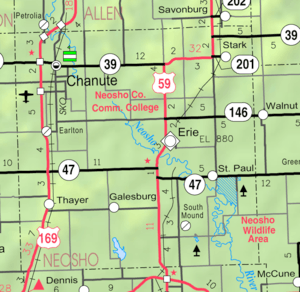 KDOT map of Neosho County (legend) | |
| Coordinates: 37°28′21″N 95°21′21″W / 37.47250°N 95.35583°WCoordinates: 37°28′21″N 95°21′21″W / 37.47250°N 95.35583°W | |
| Country | United States |
| State | Kansas |
| County | Neosho |
| Area[1] | |
| • Total | 0.17 sq mi (0.44 km2) |
| • Land | 0.17 sq mi (0.44 km2) |
| • Water | 0 sq mi (0 km2) |
| Elevation | 981 ft (299 m) |
| Population (2010)[2] | |
| • Total | 126 |
| • Estimate (2012[3]) | 124 |
| • Density | 741.2/sq mi (286.2/km2) |
| Time zone | Central (CST) (UTC-6) |
| • Summer (DST) | CDT (UTC-5) |
| ZIP code | 66740 |
| Area code(s) | 620 |
| FIPS code | 20-25150[4] |
| GNIS feature ID | 0469684[5] |
Galesburg is a city in Neosho County, Kansas, United States. As of the 2010 census, the city population was 126.[6]
History
Galesburg was laid out and platted in 1871 when the railroad was extended to that point.[7][8] A post office established in Rose Hill (an extinct town) was moved to Galesburg, and opened in March 1871.[9]
Geography
Galesburg is located at 37°28′21″N 95°21′21″W / 37.472415°N 95.355892°W (37.472415, -95.355892).[10] According to the United States Census Bureau, the city has a total area of 0.17 square miles (0.44 km2), all of it land.[1]
Climate
The climate in this area is characterized by hot, humid summers and generally mild to cool winters. According to the Köppen Climate Classification system, Galesburg has a humid subtropical climate, abbreviated "Cfa" on climate maps.[11]
Demographics
| Historical population | |||
|---|---|---|---|
| Census | Pop. | %± | |
| 1880 | 63 | — | |
| 1910 | 183 | — | |
| 1920 | 205 | 12.0% | |
| 1930 | 199 | −2.9% | |
| 1940 | 165 | −17.1% | |
| 1950 | 189 | 14.5% | |
| 1960 | 128 | −32.3% | |
| 1970 | 146 | 14.1% | |
| 1980 | 181 | 24.0% | |
| 1990 | 160 | −11.6% | |
| 2000 | 150 | −6.2% | |
| 2010 | 126 | −16.0% | |
| Est. 2015 | 122 | [12] | −3.2% |
| U.S. Decennial Census | |||
2010 census
As of the census[2] of 2010, there were 126 people, 58 households, and 39 families residing in the city. The population density was 741.2 inhabitants per square mile (286.2/km2). There were 65 housing units at an average density of 382.4 per square mile (147.6/km2). The racial makeup of the city was 98.4% White, 0.8% Native American, and 0.8% from two or more races. Hispanic or Latino of any race were 2.4% of the population.
There were 58 households of which 20.7% had children under the age of 18 living with them, 50.0% were married couples living together, 12.1% had a female householder with no husband present, 5.2% had a male householder with no wife present, and 32.8% were non-families. 32.8% of all households were made up of individuals and 13.8% had someone living alone who was 65 years of age or older. The average household size was 2.17 and the average family size was 2.72.
The median age in the city was 50.5 years. 19% of residents were under the age of 18; 5.7% were between the ages of 18 and 24; 22.3% were from 25 to 44; 30.9% were from 45 to 64; and 22.2% were 65 years of age or older. The gender makeup of the city was 50.0% male and 50.0% female.
2000 census
As of the census[4] of 2000, there were 150 people, 59 households, and 46 families residing in the city. The population density was 872.4 people per square mile (340.7/km2). There were 72 housing units at an average density of 418.7 per square mile (163.5/km2). The racial makeup of the city was 97.33% White, 2.00% from other races, and 0.67% from two or more races. Hispanic or Latino of any race were 4.00% of the population.
There were 59 households out of which 33.9% had children under the age of 18 living with them, 67.8% were married couples living together, 6.8% had a female householder with no husband present, and 22.0% were non-families. 22.0% of all households were made up of individuals and 11.9% had someone living alone who was 65 years of age or older. The average household size was 2.54 and the average family size was 2.93.
In the city the population was spread out with 30.0% under the age of 18, 9.3% from 18 to 24, 20.7% from 25 to 44, 21.3% from 45 to 64, and 18.7% who were 65 years of age or older. The median age was 36 years. For every 100 females there were 120.6 males. For every 100 females age 18 and over, there were 105.9 males.
The median income for a household in the city was $32,250, and the median income for a family was $33,500. Males had a median income of $29,000 versus $22,188 for females. The per capita income for the city was $12,713. There were 8.3% of families and 13.8% of the population living below the poverty line, including 25.5% of under eighteens and 14.3% of those over 64.
References
- 1 2 "US Gazetteer files 2010". United States Census Bureau. Retrieved 2012-07-06.
- 1 2 "American FactFinder". United States Census Bureau. Retrieved 2012-07-06.
- ↑ "Population Estimates". United States Census Bureau. Retrieved 2013-05-29.
- 1 2 "American FactFinder". United States Census Bureau. Retrieved 2008-01-31.
- ↑ "US Board on Geographic Names". United States Geological Survey. 2007-10-25. Retrieved 2008-01-31.
- ↑ "2010 City Population and Housing Occupancy Status". U.S. Census Bureau. Retrieved March 19, 2012.
- ↑ Blackmar, Frank Wilson (1912). Kansas: A Cyclopedia of State History, Embracing Events, Institutions, Industries, Counties, Cities, Towns, Prominent Persons, Etc. Standard Publishing Company. p. 706.
- ↑ Duncan, L. Wallace (1902). History of Neosho and Wilson Counties, Kansas. Monitor Printing Company. p. 75.
- ↑ "Kansas Post Offices, 1828-1961 (archived)". Kansas Historical Society. Archived from the original on October 9, 2013. Retrieved 20 June 2014.
- ↑ "US Gazetteer files: 2010, 2000, and 1990". United States Census Bureau. 2011-02-12. Retrieved 2011-04-23.
- ↑ Climate Summary for Galesburg, Kansas
- ↑ "Annual Estimates of the Resident Population for Incorporated Places: April 1, 2010 to July 1, 2015". Retrieved July 2, 2016.
External links
| Wikimedia Commons has media related to Galesburg, Kansas. |
- City
- Schools
- USD 101, local school district
- Maps
- Galesburg City Map, KDOT
Municipalities and communities of Neosho County, Kansas, United States | ||
|---|---|---|
| Cities | 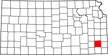 | |
| Unincorporated communities | ||
| Civil townships | ||