Galata, Montana
| Galata, Montana | |
|---|---|
| Unincorporated community | |
 Galata, Montana  Galata, Montana | |
| Coordinates: 48°28′32″N 111°21′08″W / 48.47556°N 111.35222°WCoordinates: 48°28′32″N 111°21′08″W / 48.47556°N 111.35222°W | |
| Country | United States |
| State | Montana |
| County | Toole |
| Elevation | 3,100 ft (900 m) |
| Time zone | Mountain (MST) (UTC-7) |
| • Summer (DST) | MDT (UTC-6) |
| ZIP code | 59444 |
| Area code(s) | 406 |
| GNIS feature ID | 771676[1] |
Galata is an unincorporated community in Toole County, Montana, United States. Galata is located along the Hi-Line near U.S. Route 2, 23.2 miles (37.3 km) east of Shelby. The community has a post office with ZIP code 59444, which opened on July 12, 1902.[2][3]
References
- ↑ "Galata". Geographic Names Information System. United States Geological Survey.
- ↑ United States Postal Service (2012). "USPS - Look Up a ZIP Code". Retrieved 2012-02-15.
- ↑ "Postmaster Finder - Post Offices by ZIP Code". United States Postal Service. Retrieved July 8, 2014.
Municipalities and communities of Toole County, Montana, United States | ||
|---|---|---|
| City | 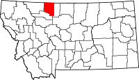 | |
| Towns | ||
| CDP | ||
| Unincorporated communities | ||
This article is issued from Wikipedia - version of the 8/8/2016. The text is available under the Creative Commons Attribution/Share Alike but additional terms may apply for the media files.