Frederiksted Historic District
|
Frederiksted Historic District | |
|
The Rorqual, 2009 | |
 | |
| Location | Roughly bounded by Fisher St., the cemetery, Fort Frederick, Frederiksted, United States Virgin Islands |
|---|---|
| Coordinates | 17°42′53″N 64°53′29″W / 17.71472°N 64.89139°WCoordinates: 17°42′53″N 64°53′29″W / 17.71472°N 64.89139°W |
| Built | 1752 |
| Architect | Multiple |
| Architectural style | Late Victorian, Georgian, Gothic Revival |
| NRHP Reference # | 76001853 |
| Added to NRHP | August 9, 1976[1] |
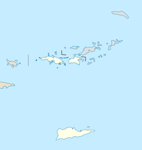
Frederiksted Historic District is a historic district located on the island of Saint Croix in the United States Virgin Islands. It was listed on the U.S. National Register of Historic Places in 1976.[1]
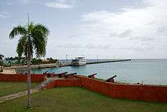
Frederiksted Historic District includes the original town laid out in a gridiron plan in 1751. Fort Frederik, which now houses a museum, was the original focal point of the town plan. The original buildings were destroyed in a fire in 1758. In 1878, plantation workers set fire to much of the town. The fire damaged areas were rebuilt, with many of the buildings reflecting Georgian and Late Victorian architectural detailing. Significant buildings in the district include the Fort Frederik and the Customs House.[2][3]
See also
References
- 1 2 National Park Service (2008-04-15). "National Register Information System". National Register of Historic Places. National Park Service.
- ↑ "Frederiksted Historic District". National Register of Historic Places. Retrieved March 25, 2016.
- ↑ "Frederiksted Historic District". The Virgin Islands Daily News. May 25, 1979. Retrieved March 25, 2016.
External links
- The Vernacular Architecture of Fredrikstad Robert S. Brown (1978)
| Wikimedia Commons has media related to Frederiksted Historic District. |
| Topics | |
|---|---|
| Lists by states |
|
| Lists by insular areas | |
| Lists by associated states | |
| Other areas | |
| |
This article is issued from Wikipedia - version of the 11/26/2016. The text is available under the Creative Commons Attribution/Share Alike but additional terms may apply for the media files.