Florida State Road 804
| ||||
|---|---|---|---|---|
 | ||||
| Route information | ||||
| Maintained by FDOT | ||||
| Length: | 9.870 mi[1] (15.884 km) | |||
| Existed: | 1945 renumbering (definition) – present | |||
| Major junctions | ||||
| West end: |
| |||
|
| ||||
| East end: |
| |||
| Location | ||||
| Counties: | Palm Beach | |||
| Highway system | ||||
| ||||

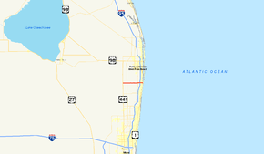
State Road 804 (SR 804) is a 9.843 miles (15.841 km) long east–west highway serving as a major commercial and commuter road through Boynton Beach in southern Palm Beach County, Florida. It is known locally and signed as Boynton Beach Boulevard for nearly all of its route, with the exception of when the road becomes concurrent with US 1 southward for two blocks, then continues along Ocean Avenue in downtown Boynton Beach to its eastern terminus at SR A1A. The western terminus of SR 804 is at the junction of US 441 / SR 7, close to the eastern boundary of the Loxahatchee National Wildlife Refuge and the historic northern boundary of The Everglades. Within the city limtis of Boynton Beach, SR 804 is also known as Northwest 2nd Avenue (NW 2nd Avenue).
Route description
State Road 804's western terminus is in unincorporated Boynton Beach at the intersection of US 441–SR 7, just north of the eastern boundary of the Loxahatchee National Wildlife Refuge and the historic northern boundary of The Everglades. West of US 441, Boynton Beach Boulevard continues westbound as 100th Street South for 1/2 mile without a state road designation through several farms before terminating at a dead end. State Road 804 then heads east away from US 441 through local farms, with newer developments east of Lyons Road. The speed limit here, and on almost all of Boynton Beach Boulevard outside of the incorporated city, is 45 miles per hour (72 km/h). Two miles east of the western terminus, SR 804 has an interchange with Florida's Turnpike. East of the turnpike, Boynton Beach Boulevard enters into some residential areas, intersecting Jog Road, followed by Military Trail (formerly SR 809 and now CR 809), where soon afterwards, it has access to the Quail Ridge Country Club to the south. East of Knuth Road, Boynton Beach Boulevard enters incorporated Boynton Beach and becomes more commercial, with the Boynton Beach Mall a few blocks to the north, and SR 804 intersecting with Congress Avenue, which like Military Trail is a state-turned-county road. It continues east, heading for an interchange with Interstate 95, entering downtown Boynton Beach east of the interchange, with the road ceasing to be a divided road east of NW 4th Street. The road next intersects Seacrest Boulevard, the baseline road that divides the city's east and west address, and continues east towards US 1. At the intersection with US 1, SR 804 leaves Boynton Beach Boulevard proper for US 1 (Federal Highway, and the hidden SR 5), where it continues south for two blocks. SR 804 then turns left (east) and follows Ocean Avenue in downtown Boynton Beach, along portions of the Ocean Avenue Historic District, with the other part of the district west of US 1. The road also has access to the revitalized Boynton Harbor Marina to the north before crossing a drawbridge over the Intracoastal Waterway to the eastern terminus at SR A1A (Ocean Boulevard), which is just outside the city limits in Ocean Ridge, just south of Boynton Beach's Oceanfront Park and Boynton Beach's government offices.[2][3]
History
The original designation of Boynton Beach Boulevard was State Road 195.[4] The 1945 State Road renumbering changed that designation to the current State Road 804. The road originally began as Boynton West Road at State Road 7, about 1/2 mile south of the current western terminus, connecting the farms in that area to the town of Boynton Beach to the east. Boynton West Road headed east to Military Trail at the eastern end of a sugarcane field, where the road would follow Military Trail for 1/2 mile northbound, with the field to the west. The road would continue east, and then south to Boynton West Shellrock Road (now Old Boynton Road), where the road would head east to its original eastern terminus at Dixie Highway (now Federal Highway, US 1, and SR 5) and NW 2nd Avenue.[5]
Major intersections
The entire route is in Palm Beach County.
| Location | mi[1] | km | Destinations | Notes | |
|---|---|---|---|---|---|
| | 0.000 | 0.000 | Continues west as 100th Street South | ||
| | 2.03 | 3.27 | Exit 86 (Turnpike) | ||
| | 3.600 | 5.794 | Jog Road | To SR 845 | |
| | 5.113 | 8.229 | Former SR 809 | ||
| Boynton Beach | 7.125 | 11.467 | Congress Avenue (CR 807) | Former SR 807 | |
| 7.814 | 12.575 | Old Boynton Road | Former alignment of SR 804 | ||
| 8.21 | 13.21 | Exit 57 (I-95) | |||
| 9.127 | 14.688 | Western terminus of concurrency with US 1 | |||
| 9.262 | 14.906 | Eastern terminus of concurrency with US 1 | |||
| Intracoastal Waterway | 9.501– 9.567 | 15.290– 15.397 | Ocean Avenue Bridge | ||
| Ocean Ridge | 9.870 | 15.884 | |||
1.000 mi = 1.609 km; 1.000 km = 0.621 mi
| |||||
References
- 1 2 "Straight Line Diagram of Road Inventory, SR 804". Florida Department of Transportation. January 26, 2012. Retrieved June 3, 2015.
- ↑ Google (2010-07-05). "State Road 804" (Map). Google Maps. Google. Retrieved 2010-07-05.
- ↑ Municipalities of Palm Beach County, Florida (PDF) (Map). Cartography by Palm Beach County GIS. Palm Beach County, Florida. 2010. Retrieved 23 June 2010.
- ↑ Wikisource (2007). "1945 Florida State Road renumbering". Wikisource. Retrieved 2007-11-15.
- ↑ "Boynton Beach pushes to restore Ocean Avenue's identity". The Palm Beach Post. June 2, 2010.