Farm to Market Road 1875
| ||||
|---|---|---|---|---|
| Route information | ||||
| Maintained by TxDOT | ||||
| Length: | 4.596 mi[1] (7.397 km) | |||
| Existed: | November 20, 1951[1] – present | |||
| Major junctions | ||||
| South end: |
| |||
| North end: |
| |||
| Location | ||||
| Counties: | Fort Bend | |||
| Highway system | ||||
| ||||

Farm to Market Road 1875 (FM 1875) is a state highway in the U.S. state of Texas that stays completely within Fort Bend County. The two-lane highway begins at Texas State Highway Loop 540 (Loop 540) southwest of Beasley and heads generally northwest to U.S. Route 90 Alternate (US 90A) at a location east of Tavener.
Route description
FM 1875 begins at a stop sign on Loop 540 southwest of Beasley. The highway immediately crosses the Union Pacific Railroad tracks and heads straight to the northwest for about 2.75 miles (4.43 km). In this stretch, the road passes Ward Airpark on the right at Kovar Road. At Drachenberg Road, FM 1875 curves briefly to the northeast for 0.25 miles (0.40 km) before swinging back to the northwest again. After heading northwest for 0.65 miles (1.05 km), the highway turns and goes north by northwest for the final 1.0 mile (1.6 km) before ending at a stop sign at US 90A. North of Drachenberg Road, FM 1875 is also known as Beasley Road.[2]
History
FM 1875 was first designated on November 20, 1951, to run about 4.8 miles (7.7 km) from US 90A near Tavener to US 59 near Beasley.[1] On April 14, 1980 a 3.1 miles (5.0 km) section of US 59 near Beasley became Loop 540.[3]
Major intersections
The entire highway is in Fort Bend County.
| Location | mi | km | Destinations | Notes | |
|---|---|---|---|---|---|
| Beasley | 0.0 | 0.0 | Southern terminus of FM 1875 | ||
| Tavener | 4.596 | 7.397 | Northern terminus of FM 1875 | ||
| 1.000 mi = 1.609 km; 1.000 km = 0.621 mi | |||||
Gallery
-
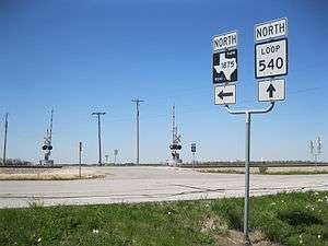
Looking northwest from Loop 540 and FM 1875
-

View south on FM 1875 near US 90A east of Tavener
See also
 Texas portal
 U.S. Roads portal
References
- 1 2 3 Transportation Planning and Programming Division (n.d.). "Farm to Market Road No. 1875". Highway Designation Files. Texas Department of Transportation. Retrieved March 27, 2013.
- ↑ Google (March 27, 2013). "Farm to Market Road 1875" (Map). Google Maps. Google. Retrieved March 27, 2013.
- ↑ Transportation Planning and Programming Division (n.d.). "State Highway Loop No. 540". Highway Designation Files. Texas Department of Transportation. Retrieved March 27, 2013.