Extreme points of Wales
This is a list of the extreme points and extreme elevations in Wales.
Wales

Middle Mouse (Ynys Badrig) as seen from Anglesey (Ynys Mon)
- Northernmost point – Middle Mouse, off Anglesey at 53°26′N 4°26′W / 53.433°N 4.433°W
- Northernmost settlement – Llanlleiana, Anglesey at 53°25′N 4°25′W / 53.417°N 4.417°W
- Southernmost point – Flat Holm, Cardiff, off Lavernock Point, Vale of Glamorgan at 51°22′N 3°7′W / 51.367°N 3.117°W
- Southernmost settlement – Rhoose, Vale of Glamorgan at 51°23′N 3°20′W / 51.383°N 3.333°W
- Westernmost point – The Smalls, Pembrokeshire
- Westernmost settlement – Treginnis, Pembrokeshire at 51°52′N 5°18′W / 51.867°N 5.300°W
- Easternmost point – Lady Park Wood, near Monmouth, Monmouthshire at 51°49′N 2°39′W / 51.817°N 2.650°W
- Easternmost settlement – Chepstow, Monmouthshire at 51°37′N 2°39′W / 51.617°N 2.650°W
Wales (mainland)
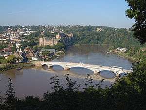
Chepstow showing border
- Northernmost point – Point of Ayr, Flintshire at 53°21′N 3°19′W / 53.350°N 3.317°W
- Northernmost settlement – Talacre, Flintshire at 53°21′N 3°19′W / 53.350°N 3.317°W
- Southernmost point – Breaksea Point, Vale of Glamorgan at 51°22′N 3°24′W / 51.367°N 3.400°W
- Southernmost settlement – Rhoose, Vale of Glamorgan at 51°23′N 3°20′W / 51.383°N 3.333°W
- Westernmost point – Pen Dal-aderyn, Pembrokeshire at 51°51′N 5°19′W / 51.850°N 5.317°W
- Westernmost settlement – Treginnis, Pembrokeshire at 51°52′N 5°18′W / 51.867°N 5.300°W
- Easternmost point – Lady Park Wood, near Monmouth, Monmouthshire at 51°49′N 2°39′W / 51.817°N 2.650°W
- Easternmost settlement – Chepstow, Monmouthshire at 51°37′N 2°39′W / 51.617°N 2.650°W
Centre point
Main article: Centre points of the United Kingdom
The centre point of Wales is dependent on whether only the mainland is used for calculation or outlying islands as well.
One centre point is calculated to be near Cwmystwyth, Devil's Bridge, Ceredigion (52°19′48.791″N 3°45′59.072″W / 52.33021972°N 3.76640889°W; grid reference SN7972871704)[1]
Elevation extremes
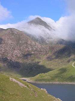
Snowdon seen from Llyn Llydaw
Main article: List of mountains in Wales
Many points are on, or near sea level, but due to high rainfall, there are no natural dry pieces of land below sea level - see rivers and lakes below.
Rivers and lakes
See also: List of rivers of Wales
The largest natural lake in Wales is Llyn Tegid (Bala Lake). Llangorse Lake is second largest.
This is a table of the longest rivers in Wales.[2] Rivers only partly in Wales are included in this table in italics.
| River | Length (miles) |
(km) | |
|---|---|---|---|
| 1 | River Severn | 220 | 354 |
| 2 | River Wye | 135 | 215 |
| 3 | River Dee | 70 | 112 |
| 4 | River Towy | 68 | 109 |
| 5 | River Usk | 56 | 90 |
| 6 | River Teifi | 50 | 80 |
| 7 | River Taff | 40 | 64 |
See also
References
- ↑ "Saving the centre of Wales". BBC. 2002-10-24. Retrieved 2010-01-04.
- ↑ Encyclopædia Britannica. 1911. "Wales"
This article is issued from Wikipedia - version of the 3/31/2016. The text is available under the Creative Commons Attribution/Share Alike but additional terms may apply for the media files.