Erwin Auxiliary Army Airfield
|
Erwin Auxiliary Army Airfield | |
|
1962 aerial USGS photo of the airfield | |
  | |
| Nearest city | Newport, Arkansas |
|---|---|
| Coordinates | 35°34′17″N 91°15′15″W / 35.57139°N 91.25417°WCoordinates: 35°34′17″N 91°15′15″W / 35.57139°N 91.25417°W |
| Area | 430 acres (170 ha) |
| Built | 1942 |
| MPS | World War II Home Front Efforts in Arkansas |
| NRHP Reference # | 08000954[1] |
| Added to NRHP | October 2, 2008 |
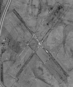
The Erwin Auxiliary Army Airfield is a former World War II-era airfield near Newport, Arkansas. The site, now in agricultural use, is located south of the city, northeast of the junction of Arkansas Highway 14 and United States Route 67. It had two runways, which formed an X shape. Each was 40–46 metres (131–151 ft) wide and 1,375 feet (419 m) long, with flanking taxiways. The airfield was built in 1942 as an auxiliary to the main Army Airfield at Newport (now Newport Municipal Airport), and was used for training and military exercises. It was briefly reactivated in 1946-49, but was definitively abandoned sometime before 1964.[2]
The airfield site was listed on the National Register of Historic Places in 2008.[1]
See also
References
- 1 2 National Park Service (2010-07-09). "National Register Information System". National Register of Historic Places. National Park Service.
- ↑ "NRHP nomination for Erwin Auxiliary Army Airfield" (PDF). Arkansas Preservation. Retrieved 2015-06-07.
| Topics | |
|---|---|
| Lists by states |
|
| Lists by insular areas | |
| Lists by associated states | |
| Other areas | |
| |
This article is issued from Wikipedia - version of the 12/2/2016. The text is available under the Creative Commons Attribution/Share Alike but additional terms may apply for the media files.