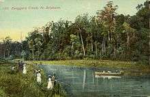
Enoggera Creek
| Enoggera | |
| Creek | |
 Enoggera Creek at The Gap, 2010 | |
| Country | Australia |
|---|---|
| State | Queensland |
| Region | South East Queensland |
| Tributaries | |
| - right | Ithaca Creek |
| City | Brisbane |
| Source | Mount Nebo |
| - location | D'Aguilar Range |
| Mouth | Breakfast Creek |
| - location | Newstead |
Enoggera Creek is a stream that rises on the D'Aguilar Range and flows into the Brisbane River. The creek's headwaters form on the southern slopes of Mount Nebo in Brisbane Forest Park.
It meanders in a south-easterly direction, leaving the undisturbed parkland and flowing through urban areas after being dammed in the suburb of Enoggera Reservoir. Enoggera Creek also passes through the Brisbane suburbs of The Gap, St Johns Wood (Locality), Ashgrove, Red Hill, Kelvin Grove, Wilston and Herston. Downstream from the Three Mile Scrubs in Kelvin Grove, Enoggera Creek is known as Breakfast Creek.[1]
Ithaca Creek flows from Mount Coot-tha and joins Enoggera Creek from the south in Red Hill. Close to the creek's confluence with the Brisbane River at Kelvin Grove, it becomes known as Breakfast Creek.
The creek is being rehabilitated and restored by the community organisation called Save Our Waterways Now.[2]
History
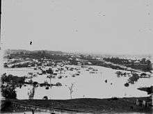
Significant flooding occurred along the creek during the major floods, including 1893 and 1974 Brisbane flood resulting in a number of houses being washed away.
A house crosses Enoggera Creek to become a hospital

Dr Thomas Brooke-Kelly[3] was one of the earliest residents of St Johns Wood, Queensland from 1931 to 1934. He and his wife Lavina and only son Noel lived down the bottom of St Johns Avenue, not far from the current pedestrian "banana" bridge. Dr Brooke-Kelly, a surgeon, had an ambition to have his own hospital. With the extension of the tram line from Oleander Drive to what was called The Terminus,[4] near Ashgrove State School, he decided to shift his home in St Johns Wood to a block of land at 438 Waterworks Road, Ashgrove, and convert it into a hospital.[5] He would add two bedrooms underneath. He employed the McKenzie Brothers, from Station Terrace Dutton Park, for a price of 600 pounds. The removal, in March 1934, became part of the folk law in the McKenzie family business. It was recalled as the most difficult job they ever did – down and across the Enogerra Creek bed, roads terrible, hill steep, house too large.[6] It took one month and two days to move it. "It was fascinating to watch...they lowered the house, in one piece, on to large timber slides, dragged the house to the creek bank and then slide and pulled it across the creek on substantial hardwood bearers.It was hard tough work and required a lot of muscle. Once across the creek the contractor raised the house on to a large wooden wheeled jinker."[7] It became Brookwell Private Hospital[8] at 438 Waterworks Road until 1937. Dr Brooke-Kelly moved many times in his career as a doctor and died, aged 93 in Clayfield. He is buried at Toowong Cemetery (with the Robinson family).
See also
References
- ↑ "Newstead". ourbrisbane.com. Brisbane City Council. Archived from the original on 8 January 2009. Retrieved 23 January 2012.
- ↑ Save Our Waterways Now: About Us
- ↑ "Doctor's Wife Ran Away With Patient.". The Mirror. Perth: National Library of Australia. 14 November 1942. p. 14. Retrieved 25 April 2013.
- ↑ "Ashgrove Tram Request.". The Courier-Mail. Brisbane: National Library of Australia. 31 March 1939. p. 8. Retrieved 25 April 2013.
- ↑ "Advertising.". The Courier-Mail. Brisbane: National Library of Australia. 3 May 1937. p. 20. Retrieved 25 April 2013.
- ↑ "No title.". The Courier-Mail. Brisbane: National Library of Australia. 12 March 1934. p. 13. Retrieved 25 April 2013.
- ↑ MacArthur, Roy (2005). Enoggera Creek and Me. From the Dam to St Johns Wood. The Gap Pioneer and History Club. p. 27. ISBN 0-9757412-1-7.
- ↑ "SOCIAL NOTES.". The Courier-Mail. Brisbane: National Library of Australia. 22 November 1934. p. 24. Retrieved 25 April 2013.
External links
![]() Media related to Enoggera Creek at Wikimedia Commons
Media related to Enoggera Creek at Wikimedia Commons
Coordinates: 27°26′28.64″S 152°59′09.55″E / 27.4412889°S 152.9859861°E