1974 Brisbane flood
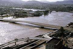 Victoria Bridge during flood | |
| Date | 7 days |
|---|---|
| Location | Ipswich, Brisbane |
| Deaths | 14[1] |
| Property damage | A$100 million[2] |

The 1974 Brisbane flood occurred in January 1974 in Brisbane, Queensland, Australia. It took place when the waterways in the city experienced significant flooding. The Brisbane River, which runs through the heart of the city, broke its banks and flooded the surrounding areas.
In total, there were 14 fatalities, 300 people injured, 8000 homes destroyed and an estimated A$68 million in damages.[3]
Flood waters in Brisbane
| Precipitation | Storm | Location | Ref. | ||
|---|---|---|---|---|---|
| Rank | mm | in | |||
| 1 | 1,947 | 76.65 | Peter 1979 | Mount Bellenden Ker | [4] |
| 2 | 1,870 | 73.62 | Rona–Frank 1999 | Mount Bellenden Ker | [4] |
| 3 | 1,318 | 51.89 | Wanda 1974 | Mount Glorious | [5] |
| 4 | 1,256.8 | 49.48 | Fletcher 2014 | Kowanyama | [6][7] |
| 5 | 1,082 | 42.60 | Aivu 1989 | Dalrymple Heights | [8] |
| 6 | 1,065 | 41.93 | May 1998 | Burketown | [9] |
| 7 | 1,000 | 39.37 | Justin 1997 | Willis Island | [10] |
| 7 | 1,000 | 39.37 | Ellie 2009 | [11] | |
| 7 | 1,000 | 39.37 | Oswald 2013 | Tully | [12] |
| 8 | 927 | 36.50 | Unnamed April 1898 | Whim Creek | [13][14] |
It had been an exceptionally wet spring, and by the end of October most of southern Queensland's river systems were nearing capacity. Cyclone Wanda pushed the systems to the limit, and drew the monsoonal trough southward, providing the additional rainfall to the Brisbane River, Bremer River and Stanley River catchments to produce widespread and severe flooding. In the early morning of 25 January heavy rain began to fall on Brisbane. During a 36-hour period 642 mm of rain fell on the city.[15] These torrential rains were caused by Tropical Cyclone Wanda, a relatively weak cyclone which did not even rate as a category 1 cyclone.[16]
Continual, heavy rain had fallen for three weeks, leading up to the flood, which occurred on Sunday, 27 January 1974, during the Australia Day weekend. The floods peaked at 6.6 metres (22 ft) according to the Port Office gauge at high tide at 2:15 am on 29 January.[17] The peak flooding in the location of the city gauge was approximately 5.5 metres (18 ft).[18]
Damage
Large areas were inundated, with at least 6,700 homes flooded. Around 13,000 buildings were affected by flooding in some way.[19] Buildings in the Brisbane central business district were particularly hard hit.[15] Damage at the time was estimated at some $200 million. The 67,320 tonne Robert Miller unmoored at Kangaroo Point and became adrift in the river. Two tugboats were needed to control the 15 m high and 239 m long oil tanker.[20] The Robert Miller was the largest ship ever built in Australia at the time.[21] A barge was sunk after becoming caught under and damaging the Centenary Bridge.[20] The most flood affected suburb of Brisbane was Rocklea.[22]
Close to the city Ipswich, 1,800 premises were affected by flooding.[23] The total damage in Brisbane and the surrounding areas was estimated at over A$980 million (1974 values).[19] Insurance claims totalled $328 million.[19] While not as high as the floods in the 1800s this flood is considered to have been worse due to Brisbane's rapidly increasing population at the time.
Many houses were also damaged by land subsidence and land slippage associated with the flooding and high rainfall.[24]
Fatalities
Fourteen people lost their lives,[19] including 10 people who were drowned in the suburbs of Yeronga, Newmarket, St Lucia, and the city of Ipswich upriver and to the west.
The first flood related deaths were at 11:20pm on 24 January. Raymond Roy Davidson (29 years, from Wacol) and Hazel Dulcie Afflick (40 years) were killed in a head-on collision at Wacol, both drivers being blinded by gale force winds and heavy rain.
An army amphibious LARC vehicle was carrying out excavation work at Bellbowrie when the vehicle hit submerged power lines which were still live. Two men, Corporal Neville Hourigan and Captain Ian Kerr of the Australian Army Reserve (then called the Citizens Military Force) were thrown from the vehicle. Bill Lickiss jumped into the water to save them.[25] Hourigan died at the scene and Kerr's body was found after the flood had subsided. Lickiss was awarded the Queen's Gallantry Medal.[26]
A young child, Shane David Patterson (of Yeronga) was swept from his father's arms on a causeway over Oxley Creek in Inala and drowned. An elderly woman was washed away in Ashgrove on 26 January. After the floods receded, the body of a man was found at Milton, and the bodies of three other were found in South Brisbane.
In addition to those that drowned, Robert Adams (aged 56 years) died of a heart attack during an evacuation of a caravan park at Newmarket, and Aiden Sutton, a civilian working with the Queensland Police, aged 50 years, was found dead at home.[25]
Aftermath
After the flood, a series of flood mitigation measures were implemented in Southeast Queensland.
The flood was a defining event for a generation of Brisbane residents with 8,500 homes flooded in Brisbane and Ipswich, 6,000 of these could not be recovered[27] from an inland sea of 200 square kilometres (20,000 ha) formed by the flood waters.
The flood had massive economic implications due to loss of export infrastructure.
See also
Notes
- ↑ Carbone, Delana. "Floods: 10 deadliest in Australian history". Australian Geographic. Retrieved 25 September 2013.
- ↑ Carbone, Delana. "Floods: 10 deadliest in Australian History". Australian Geographic. Retrieved 25 September 2013.
- ↑ Carbone, Delana. "Floods: 10 of the deadliest in Australian history". Australian Geographic. Retrieved 25 September 2013.
- 1 2 "Climate Education: Flood". Australian Bureau of Meteorology. Archived from the original on 17 March 2009. Retrieved January 18, 2011.
- ↑ Bureau of Meteorology. Tropical Cyclones in Queensland. Retrieved on 17 July 2015.
- ↑ "Tropical Cyclone Fletcher Impacts". Bureau of Meteorology. Government of Australia. 2014. Retrieved 5 March 2014.
- ↑ "Kowanyama, Queensland February 2014 Daily Weather Observations". Bureau of Meteorology. Government of Australia. 2014. Archived from the original (PDF) on 6 March 2014. Retrieved 6 March 2014.
- ↑ "Report on Severe Tropical Cyclone Aivu: Rainfall" (PDF). Bureau of Meteorology. Government of Australia. 6 June 1990. p. 17–18. Retrieved 13 March 2014.
- ↑ "Tropical Cyclone May". Australian Bureau of Meteorology. 2013. Retrieved 29 January 2013.
- ↑ Queensland Tropical Cyclone Warning Centre (2014). "Tropical Cyclone Justin" (PDF). Australian Bureau of Meteorology. Government of Australia. Retrieved 11 March 2014.
- ↑ "Tropical Cyclone Ellie". Australian Bureau of Meteorology. 2009. Retrieved 27 January 2013.
- ↑ Brian Williams and Peter Michael (24 January 2013). "Ex-cyclone Oswald heads south with heavy rain tipped for long weekend". Australian Associated Press. The Courier Mail. Retrieved 24 January 2013.
- ↑ Tropical Cyclones Affecting the Karratha/Dampier/Roebourne region (Report). Australian Bureau of Meteorology. Archived from the original on 4 August 2014. Retrieved 4 August 2014.
- ↑ Bureau of Meteorology. Tropical Cyclone Extremes. Retrieved on 2 January 2008.
- 1 2 McBride, Frank; et al. (2009). Brisbane 150 Stories. Brisbane City Council Publication. pp. 256–257. ISBN 978-1-876091-60-6.
- ↑ "Season 1973-1974 Tropical Cyclone WANDA Track Map". Retrieved 2013-09-25.
- ↑ Bureau of Meteorology (1974) pp. 35
- ↑ "Brisbane River at City Gauge: Highest Annual Flood Peaks". Bureau of Meteorology, Commonwealth of Australia. Retrieved 12 January 2011.
- 1 2 3 4 Gregory, Helen; Dianne Mclay (2010). Building Brisbane's History: Structure, Sculptures, Stories and Secrets. Warriewood, New South Wales: Woodslane Press. p. 148. ISBN 9781921606199.
- 1 2 Bureau of Meteorology (1974) pp. 38–39
- ↑ Geoff Strong (17 January 2011). "The boat that almost became a ruinous dam". Brisbane Times. Fairfax Digital. Retrieved 20 February 2011.
- ↑ "Rocklea". Queensland Places. Centre for the Government of Queensland. Retrieved 22 September 2012.
- ↑ Gary Kitchener (11 January 2011). "Queensland rebuilding 'huge task'". BBC News. Archived from the original on 17 February 2011. Retrieved 20 February 2011.
- ↑ Bureau of Meteorology. Brisbane Floods January 1974. Commonwealth of Australia. p.8.
- 1 2 Worst Disasters. Malcolm Brown. 2002.
- ↑ "Brisbane '74: Long weekend from hell". Courier-Mail. 24 January 2014.
- ↑ . 4WD Australia. Retrieved on 28 April 2015.
References
- "Brisbane floods January 1974: Report by Director of Meteorology" (PDF). Canberra: Bureau of Meteorology, Commonwealth of Australia. 1974. Retrieved 25 September 2013.
External links
| Wikimedia Commons has media related to 1974 Brisbane flood. |
- The "Big Wet", Bureau of Meteorology
- Known Floods in the Brisbane and Bremer River Basin, Bureau of Meteorology
- Flood map of Brisbane & suburbs / drawn and published at the Survey Office, Department of Lands, Brisbane, Feb. 1974 (Link via National Library of Australia)
Coordinates: 27°28′S 153°02′E / 27.467°S 153.033°E