Elvaton, California
Coordinates: 38°43′38″N 121°48′23″W / 38.72722°N 121.80639°W
| Elvaton | |
|---|---|
| Former settlement | |
 Elvaton Location in California | |
| Coordinates: 38°43′38″N 121°48′23″W / 38.72722°N 121.80639°W | |
| Country | United States |
| State | California |
| County | Yolo County |
| Elevation[1] | 89 ft (27 m) |
Elvaton (also, Elvation)[2] is a former settlement in Yolo County, California. It was located on the Southern Pacific Railroad 3.5 miles (5.6 km) north-northeast of Woodland,[2] at an elevation of 89 feet (27 m). It still appeared on maps as of 1915.
References
- ↑ U.S. Geological Survey Geographic Names Information System: Elvaton, California
- 1 2 Durham, David L. (1998). California's Geographic Names: A Gazetteer of Historic and Modern Names of the State. Clovis, Calif.: Word Dancer Press. p. 482. ISBN 1-884995-14-4.
Municipalities and communities of Yolo County, California, United States | ||
|---|---|---|
| Cities | 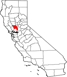 | |
| CDPs | ||
| Unincorporated communities |
| |
| Ghost towns | ||
| Footnotes | ‡This populated place also has portions in an adjacent county or counties | |
This article is issued from Wikipedia - version of the 1/26/2011. The text is available under the Creative Commons Attribution/Share Alike but additional terms may apply for the media files.